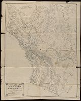
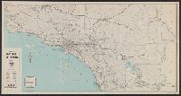
Map of Riverside and New 1928 map of Riverside, California and road map of Southern California
Description:
"Copyright by Geo. C. Thomas.", "Southern California highway map" (scale [ca. 1:1,360,000]), text, and advertisements on verso., and Includes index and advertisements.
Publisher:
Thomas Bros.,
Subject (Geographic):
Riverside (Calif.)--Maps
Subject (Name):
Thomas, Geo. Coupland (George Coupland)
Subject (Topic):
Roads--California, Southern--Maps and Streets--California--Riverside--Maps
Automobile Club of Southern California. Route and Map Service
Published / Created:
[191-?]
Call Number:
844gmb 191X
Container / Volume:
BRBL_00615
Image Count:
2
Resource Type:
Maps, Atlases & Globes
Description:
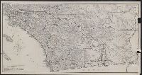
Covers the counties of Tulare, Inyo, San Luis Obispo, Kern, San Bernardino, and south to the Mexican border., In lower left: EJB., and Relief shown by hachures and spot heights.
Publisher:
The Club,
Subject (Topic):
Roads--California, Southern--Maps and Roads--California--Maps
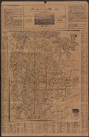
Auto road map of Los Angeles, Riverside, Orange, San Bernardino counties., Cities of Pasadena, South Pasadena, San Marino, and Altadena, Lamand Park and adjacent territory in Los Angeles County., and New map, (street guide), city of Pasadena, South Pasadena, Sa
Description:
At head of panel title: New map (street guide), Auto road map of Los Angeles "published by Western Map and Publishing Company.", Distance list and text on verso., Includes index, ill., and text., Panel title., Relief shown by hachures and spot heights., and Thurston's auto road map of Los Angeles, Riverside, Orange, San Bernardino counties.
Publisher:
[Albert G. Thurston?],
Subject (Geographic):
California, Southern--Maps, Pasadena (Calif.)--Maps, and Pasadena Metropolitan Area (Calif.)--Maps
Subject (Name):
Western Map and Publishing Co
Subject (Topic):
Roads--California, Southern--Maps, Roads--California--Pasadena Metropolitan Area--Maps, and Streets--California--Pasadena--Maps
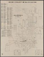
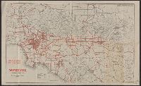
101-mile drive on the rim of the world., Map of principal highways in Southern California., and Map of the city of San Bernardino, California, and the "Rim of the world drive" in the San Bernardino Mountains
Description:
Includes index, statistics, and list of public buildings, schools and parks., Publisher from label on verso covering text of "issued by the San Bernardino Chamber of Commerce.", and Text, "Map of principal highways in Southern California," and "[Map of] The 101-mile drive on the rim of the world" (both maps "courtesy of Automobile Club of Southern California") on verso.
Publisher:
Supplied by Rand McNally & Company,
Subject (Geographic):
San Bernardino (Calif.)--Maps
Subject (Name):
Automobile Club of Southern California, Lowe, A. H, and Rand McNally and Company
Subject (Topic):
Roads--California, Southern--Maps and Streets--California--San Bernardino--Maps
Covers the area from the San Gabriel mountains to the Mexican border., In lower left: 417., Panel title., and Relief shown by hachures and spot heights.
Publisher:
Automobile Club of Southern California,
Subject (Topic):
Roads--California, Southern--Maps and Roads--California--Maps
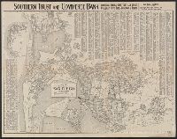
Automobile road map :, Automobile road map of the Los Angeles Region, Automobile routes, Ventura and Santa Barbara, from Los Angeles, Northwest., Motor routes and connecting roads of San Diego County., and Motor routes between Los Angeles, San Francisco, Sacramen
Description:
"Copyrighted 1919 by the Clason Map Co.", Advertisements and text on verso., and On verso: Motor routes and connecting roads of San Diego County -- Motor routes between Los Angeles, San Francisco, Sacramento and Reno -- Automobile routes, Ventura and Santa Barbara, from Los Angeles, Northwest.
Publisher:
Security Trust & Savings Bank,
Subject (Geographic):
Los Angeles County (Calif.)--Maps and Los Angeles Region (Calif.)--Maps
Subject (Name):
Clason Map Co and Security Trust & Savings Bank (Los Angeles, Calif.)
Subject (Topic):
Roads--California, Southern--Maps, Roads--California--Los Angeles Region--Maps, Roads--California--Maps, and Roads--California--San Diego County--Maps