Search
You Searched For
Search Results
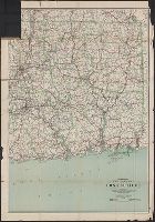
- Creator:
- C.S. Hammond & Company
- Published / Created:
- c1916.
- Call Number:
- 766gmb 1916H
- Container / Volume:
- BRBL_00475
- Image Count:
- 1
- Resource Type:
- Maps, Atlases & Globes
- Alternative Title:
- Hammond's auto route map of eastern Connecticut
- Description:
- Includes the eastern part of Connecticut from Hartford east to the Rhode Island border.
- Publisher:
- C.S. Hammond & Co.,
- Subject (Geographic):
- Connecticut--Maps
- Subject (Name):
- Geological Survey (U.S.) and U.S. Coast and Geodetic Survey
- Subject (Topic):
- Roads--Connecticut--Maps
- Found in:
- Beinecke Rare Book and Manuscript Library > Hammond's new road map of Connecticut (Eastern part) / based on the surveys of the United States Geological Survey, United States Coast and Geodetic Survey and the various local surveys, revised and corrected ... C.S. Hammond & Company.
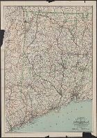
- Creator:
- C.S. Hammond & Company
- Published / Created:
- 1916
- Call Number:
- 766gmb 1916H
- Container / Volume:
- BRBL_00475
- Image Count:
- 1
- Resource Type:
- Maps, Atlases & Globes
- Alternative Title:
- Hammond's auto route map of western Connecticut
- Description:
- Includes the western part of Connecticut from The New York border to West Hartford and New Britain.
- Publisher:
- C.S. Hammond & Co.,
- Subject (Geographic):
- Connecticut--Maps
- Subject (Name):
- Geological Survey (U.S.) and U.S. Coast and Geodetic Survey
- Subject (Topic):
- Roads--Connecticut--Maps
- Found in:
- Beinecke Rare Book and Manuscript Library > Hammond's new road map of Connecticut (Western part) / based on the surveys of the United States Geological Survey, United States Coast and Geodetic Survey and the various local surveys, revised and corrected ... C.S. Hammond & Company.
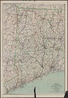
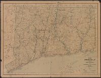
- Published / Created:
- 1918
- Call Number:
- 766gmb 1918
- Container / Volume:
- BRBL_00475
- Image Count:
- 1
- Resource Type:
- Maps, Atlases & Globes
- Publisher:
- State Highway Department,
- Subject (Name):
- Connecticut. State Highway Dept
- Subject (Topic):
- Roads--Connecticut--Maps
- Found in:
- Beinecke Rare Book and Manuscript Library > Map of Connecticut, showing trunk line system and connecting state aid roads / prepared by State Highway Department.