Map of the world showing routes of Cook's expeditions, with notes on ice, wild life etc. seen. Relief shown pictorially; imaginary coastline for eastern coast of Australian Bight., No. 1 of 43 maps bound together in composite atlas., and Scale [ca.1:68 000 000].
Publisher:
Published by Wm. Faden, Geographer to the King, Charing Cross
Subject (Name):
Cook, James, 1728-1779 and Mulgrave, Constantine John Phipps, Lord
Subject (Topic):
Discoveries in geography --Maps --To 1800 and World maps --Early works to 1800
Twenty four new and accurate maps of the several parts of Europe ... : all (except the last) new
Image Count:
1
Alternative Title:
The world in general
Description:
In pencil on verso: 1.
Subject (Name):
Barker, B. (Benjamin), d. 1764, bookseller, Clements, Henry, d. 1719, bookseller, King, Charles, d. 1735, bookseller, Nicholson, John, d. ca. 1717, bookseller, Parker, Richard, fl. 1692-1725, bookseller, and Tooke, Benjamin, d. 1716, bookseller
Subject (Topic):
Atlases --Early works to 1800 and World maps --Early works to 1800
Collection Created:
[London] : Sold by J. Nicholson at the King’s-Arms in Little Britain, Benj. Barker and Charles King ..., Benj. Tooke ..., Hen. Clements ..., R. Parker and Ralph Smith under the Royal-Exchange ..., [1715?]
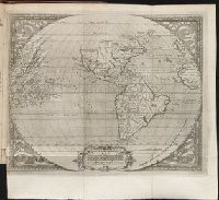
Eastern old world hemisphere has imprint: London ... Dec. 1st, 1786 by William Faden., No. 2 of 43 maps bound together in composite atlas., Scale [1:60,000,000]., and Shows western and eastern hemispheres separately.
Ed. statement appears on Northern Hemisphere map only., No. 3 of 43 maps bound together in composite atlas., Relief shown pictorially., Scale [ca. 1:41,000,000. At equator]., and Shows tracks of various ocean voyages.
Publisher:
William Faden
Subject (Geographic):
Northern Hemisphere --Maps --Early works to 1800 and Southern Hemisphere --Maps --Early works to 1800
De orbe novo Petri Martyris Anglerii Mediolanensis, protonotarij, & Caroli quinti Senatoris decades
Image Count:
1
Description:
Copy of map published in Hakluyt's Voyages in 1587., Preceding p. 1., and Teaching resource: Professor John Mack Faragher, History 141: The American West.
Subject (Geographic):
America --Discovery and exploration, Latin America --Description and travel, and West Indies --History
Mecometrie de leymant, cest a dire La maniere de mesvrer les longitudes par le moyen de l’eymant
Image Count:
1
Description:
Bound in preceding t.p. for pt. [2] (Premier livre de la Mecometrie arithmetique de l’eymant)., Imperfect: map rubbed, with some loss of map and text., Map has small tear on left edge at gutter., and Scale [ca. 1:100,000,000].
Subject (Topic):
Longitude --Early works to 1800 and World maps --Early works to 1800
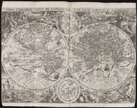
John Huighen van Linschoten, his Discours of Voyages into ye Easte & West Indies
Image Count:
1
Abstract:
Map features two hemispheres and two zodiac charts as well as representations including people, animals, structures, and plant life of the geographical areas of "Europa", "Asia", "Africa", Magallanica", "Peruana", and "Mexicana" within the remainder of the frame.
Description:
Bound in before p. 1., Ink from preceding portrait has bled onto verso of map., Map has some small tears along fold lines., and Map has two small stains of ink in the center below "La Ascension".
Subject (Topic):
Voyages and travels --Early works to 1800, World maps --Early works to 1800, and Zodiac --Early works to 1800
Collection Created:
[London] : Printed at London by [John Windet for] Iohn Wolfe, printer to ye Honorable Cittie of London, [1598]
Hase, Johann Matthias, 1684-1742 Homann Erben (Firm) Lowitz, G. M. (George Moritz), 1722-1774
Published / Created:
1746
Call Number:
1975 Folio 31
Collection Title:
[Atlas factice of 42 maps, produced by the Homann Erben firm]
Image Count:
1
Alternative Title:
Mappe-monde qui represente les deux hemispheres savoir celui de l’orient et celui de l’occident, tiree des quatre cartes generales de feu M. le profess. Hasius, dressee par Mr. G.M. Lowitz et publiee par les Heritiers de Homann, avec privil. imper and Planiglobii terrestris mappa vniversalis
Publisher:
Homann Erben
Subject (Topic):
Atlases, German --Early works to 1800, Religion --Maps --Early works to 1800, and World maps --Early works to 1800