Search
You Searched For
Search Results
- Creator:
- Dripps, M. (Matthew)
- Published / Created:
- 1868
- Call Number:
- 771 N49 1868D
- Container / Volume:
- BRBL_00487
- Image Count:
- 21
- Resource Type:
- Maps, Atlases & Globes
- Found in:
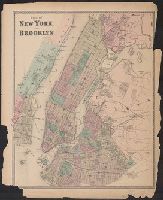
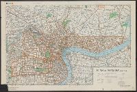
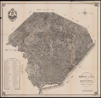
- Beinecke Rare Book and Manuscript Library > Plan of New York City from the Battery to Spuyten Duyvil Creek : showing every lot and building thereon; old farm lines, street numbers at the corners of blocks, railroads, steamboat landings, bulkhead and pier lines, etc., etc., etc. / based on the surve
- Published / Created:
- 1872?]
- Call Number:
- 771 N49 1868C
- Container / Volume:
- BRBL_00487
- Image Count:
- 1
- Resource Type:
- Maps, Atlases & Globes
- Found in:
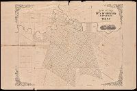
- Beinecke Rare Book and Manuscript Library > Plan of New York and Brooklyn.
- Published / Created:
- [1838?]
- Call Number:
- 771 N49 1838
- Container / Volume:
- BRBL_00485
- Image Count:
- 1
- Resource Type:
- Maps, Atlases & Globes
- Found in:
- Beinecke Rare Book and Manuscript Library > Plan of New York.
- Published / Created:
- [c1880?]
- Call Number:
- 32 Ox1 1880A
- Container / Volume:
- BRBL_00053
- Image Count:
- 2
- Resource Type:
- Maps, Atlases & Globes
- Found in:
- Beinecke Rare Book and Manuscript Library > Plan of Oxford.
- Published / Created:
- [1860?]
- Call Number:
- 32 Ox1 1860A
- Container / Volume:
- BRBL_00053
- Image Count:
- 1
- Resource Type:
- Maps, Atlases & Globes
- Found in:
- Beinecke Rare Book and Manuscript Library > Plan of Oxford.
- Published / Created:
- [1890?]
- Call Number:
- 32 Ox1 1890
- Container / Volume:
- BRBL_00053
- Image Count:
- 1
- Resource Type:
- Maps, Atlases & Globes
- Found in:
- Beinecke Rare Book and Manuscript Library > Plan of Oxford/ J. Bartholomew Edinr.
- Published / Created:
- [ca. 1887]
- Call Number:
- 38 P21 1880C
- Container / Volume:
- BRBL_00164
- Image Count:
- 1
- Resource Type:
- Maps, Atlases & Globes
- Found in:
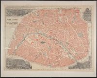
- Beinecke Rare Book and Manuscript Library > Plan of Paris on the ribbon system [cartographic material] : souvenir of the grand warehouse of the Bon Marché (founded by Aristide Boucicaut).
- Published / Created:
- 1880
- Call Number:
- 766 H26 1880
- Container / Volume:
- BRBL_00468
- Image Count:
- 1
- Resource Type:
- Maps, Atlases & Globes
- Found in:
- Beinecke Rare Book and Manuscript Library > Plan of Park River showing outlets of present sewers and location of a proposed intercepting sewers and location of a proposed intercepting sewer.
- Published / Created:
- 1859
- Call Number:
- 739 F86 1859
- Container / Volume:
- BRBL_00389
- Image Count:
- 1
- Resource Type:
- Maps, Atlases & Globes
- Found in:
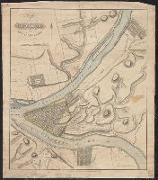
- Beinecke Rare Book and Manuscript Library > Plan of Part of Fraser's River...
- Published / Created:
- [1825?]
- Call Number:
- 774 P68 1825
- Container / Volume:
- BRBL_00500
- Image Count:
- 1
- Resource Type:
- Maps, Atlases & Globes
- Found in:
- Beinecke Rare Book and Manuscript Library > Plan of Pittsburgh and adyacent country, surveyed by Wm. Darby.
- Call Number:
- 1973 Folio 67
- Collection Title:
- The West-India pilot: containing piloting directions for Port Royal and Kingston harbours in
- Image Count:
- 1
- Found in:
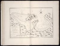
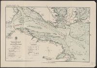
- Beinecke Rare Book and Manuscript Library > Plan of Port Antonio on the north-east side of Jamaica
- Call Number:
- 1973 Folio 67
- Collection Title:
- The West-India pilot: containing piloting directions for Port Royal and Kingston harbours in
- Image Count:
- 1
- Found in:
- Beinecke Rare Book and Manuscript Library > Plan of Port Royal harbour Rattan
- Published / Created:
- 1947
- Call Number:
- 764ad St96 1947
- Container / Volume:
- BRBL_00711
- Image Count:
- 1
- Resource Type:
- Maps, Atlases & Globes
- Found in:
- Beinecke Rare Book and Manuscript Library > Plan of Proprietors Lands in Sturbridge drawn by Levi B. Chase, Worcester County Engineering Dept. Traced by L.O. Marden ...
- Published / Created:
- [1845?]
- Call Number:
- 40 R66 1845
- Container / Volume:
- BRBL_00217
- Image Count:
- 1
- Resource Type:
- Maps, Atlases & Globes
- Found in:
- Beinecke Rare Book and Manuscript Library > Plan of Rome [cartographic material].
- Published / Created:
- [1831?]
- Call Number:
- 764 R812 1831
- Container / Volume:
- BRBL_00459
- Image Count:
- 1
- Resource Type:
- Maps, Atlases & Globes
- Found in:
- Beinecke Rare Book and Manuscript Library > Plan of Royalston ... by Jonathan Blake Jr. 1831
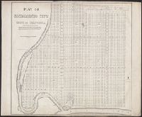
- Creator:
- Warner, William Horace
- Published / Created:
- [1850?]
- Call Number:
- 844 Sa14 1850
- Container / Volume:
- BRBL_00608
- Image Count:
- 2
- Resource Type:
- Maps, Atlases & Globes
- Found in:
- Beinecke Rare Book and Manuscript Library > Plan of Sacramento City, state of California / original survey by Captn. W.H. Warner in Decr. 1848 ; ... surveyed by Clement W. Coote, Dec. 1849 ; copied by H. Ehrenberg, surveyor.
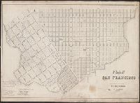
- Creator:
- Eddy, William M
- Published / Created:
- [1850?]
- Call Number:
- 844 Sa52 1850A
- Container / Volume:
- BRBL_00608
- Image Count:
- 2
- Resource Type:
- Maps, Atlases & Globes
- Found in:
- Beinecke Rare Book and Manuscript Library > Plan of San Francisco / copied and enlarged from the original of Wm. M. Eddy's, city surveyor, by H. Ehrenberg, surveyor.
- Creator:
- From the Collection: Rochambeau family
- Published / Created:
- n.d.
- Call Number:
- GEN MSS 146
- Container / Volume:
- Box 50, folder 798
- Image Count:
- 1
- Found in:
- Beinecke Rare Book and Manuscript Library > Rochambeau Papers and Rochambeau Family Cartographic Archive (GEN MSS 146) > Oversize > BOXES > Series VII. Other Rochambeau Maps > Plan of Scarborough.
- Published / Created:
- 1817
- Call Number:
- 36hc L53 1817
- Container / Volume:
- BRBL_00134
- Image Count:
- 1
- Resource Type:
- Maps, Atlases & Globes
- Found in:
- Beinecke Rare Book and Manuscript Library > Plan of Schlachsteldes um Leipzig ...
- Creator:
- United States. Army Map Service
- Published / Created:
- 1945
- Call Number:
- 56 Sh18 1945A
- Container / Volume:
- BRBL_00297
- Image Count:
- 2
- Resource Type:
- Maps, Atlases & Globes
- Found in:
- Beinecke Rare Book and Manuscript Library > Plan of Shanghai.
- Published / Created:
- 1924
- Call Number:
- 32cea 1856
- Container / Volume:
- BRBL_00075
- Image Count:
- 1
- Resource Type:
- Maps, Atlases & Globes
- Found in:
- Beinecke Rare Book and Manuscript Library > Plan of Spithead : showing the proposed evolutions at the review of the fleet by Her Majesty on Wednesday the 23rd april 1856.
- Creator:
- Bradshaw, George, 1801-1853
Henry Blacklock & Co. (Manchester, England)
- Published / Created:
- 1898?]
- Call Number:
- 352 L547 1898
- Container / Volume:
- BRBL_00108
- Image Count:
- 1
- Resource Type:
- Maps, Atlases & Globes
- Found in:
- Beinecke Rare Book and Manuscript Library > Plan of St. Petersburg / Henry Blacklock and Co.
- Published / Created:
- ca. 1890?]
- Call Number:
- 345 St62 1890
- Container / Volume:
- BRBL_00096
- Image Count:
- 1
- Resource Type:
- Maps, Atlases & Globes
- Found in:
- Beinecke Rare Book and Manuscript Library > Plan of Stockholm [cartographic material] / Henry Blacklock & Co. Ltd.
- Published / Created:
- [1835?]
- Call Number:
- 493 V24 1835
- Container / Volume:
- BRBL_00270
- Image Count:
- 1
- Resource Type:
- Maps, Atlases & Globes
- Found in:
- Beinecke Rare Book and Manuscript Library > Plan of Valetta and its Harbors. Luigi Brocktorff Lith.
- Creator:
- Gibson, J. (John)
- Call Number:
- 1973 Folio 67
- Collection Title:
- The West-India pilot: containing piloting directions for Port Royal and Kingston harbours in
- Image Count:
- 1
- Found in:
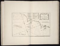
- Beinecke Rare Book and Manuscript Library > Plan of Vera Cruz
- Published / Created:
- [1910?]
- Call Number:
- 42 V67 1910B
- Container / Volume:
- BRBL_00245
- Image Count:
- 1
- Resource Type:
- Maps, Atlases & Globes
- Found in:
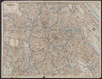
- Beinecke Rare Book and Manuscript Library > Plan of Vienna.
- Creator:
- Lawrence, C. M., surveyor
- Published / Created:
- 189-?]
- Call Number:
- 827 W44 189X
- Container / Volume:
- BRBL_00578
- Image Count:
- 1
- Resource Type:
- Maps, Atlases & Globes
- Found in:
- Beinecke Rare Book and Manuscript Library > Plan of Weleetka, Creek Nation, Indian Tery. / C.M. Lawrence, surveyor.
- Published / Created:
- 1825]
- Call Number:
- 783hc Y82 1781E
- Container / Volume:
- BRBL_00512
- Image Count:
- 1
- Resource Type:
- Maps, Atlases & Globes
- Found in:
- Beinecke Rare Book and Manuscript Library > Plan of York Town in Virginia ... exhibiting the operations of the American, french & English armies during the siege of that palce in Oct 1781. [by Maj. Sebastian Bauman].
- Creator:
- Adam, Robert, 1728-1792 , artist
- Published / Created:
- [1768]
- Call Number:
- Folio 49 3678.5+ (Oversize)
- Image Count:
- 1
- Resource Type:
- still image
- Found in:
- Lewis Walpole Library > Plan of a cottage for the Honorable Horace Walpole [art original] / Rbt. Adam arh. 1768
- Creator:
- From the Collection: St. John de Crèvecoeur, J. Hector, 1735-1813
- Published / Created:
- undated
- Call Number:
- GEN MSS 722
- Container / Volume:
- Box 6 (Oversize), folder 42
- Image Count:
- 2
- Found in:
- Beinecke Rare Book and Manuscript Library > J. Hector St. John de Crèvecoeur papers (GEN MSS 722) > Oversize > Plan of a garden
- Creator:
- Conder, Thomas, 1746 or 1747-1831, printmaker
- Published / Created:
- [1 December 1791]
- Call Number:
- 791.12.01.03
- Image Count:
- 1
- Resource Type:
- still image
- Found in:
- Lewis Walpole Library > Plan of a regular coffee plantation [graphic]
- Creator:
- Gallaudet, T. H. (Thomas Hopkins), 1787-1851
- Published / Created:
- 1825
- Call Number:
- College Pamphlets 93 11
- Image Count:
- 22
- Found in:
- Beinecke Rare Book and Manuscript Library > Plan of a seminary for the education of instructers of youth. / By Thomas H. Gallaudet, principal of the American Asylum for the Education of the Deaf and Dumb.
- Creator:
- Campbell, P. (Patrick)
- Published / Created:
- 1793
- Call Number:
- Egb 791c
- Collection Title:
- Travels in the interior inhabited parts of North America. In the years 1791 and 1792. In which is
- Image Count:
- 1
- Found in:
- Beinecke Rare Book and Manuscript Library > Plan of an American new cleared farm
- Creator:
- Hollar, Wenceslaus, 1607-1677
- Published / Created:
- 1902. and ca. 1658
- Call Number:
- 32 L84 1658/1902
- Container / Volume:
- BRBL_00736
- Image Count:
- 1
- Resource Type:
- Maps, Atlases & Globes
- Found in:
- Beinecke Rare Book and Manuscript Library > Plan of area now west central part of London, by W. Hollar (Parthey 1002)
- Creator:
- Great Britain. Commissioners of Works
- Published / Created:
- 1900
- Call Number:
- 32 L84 1680/1896
- Container / Volume:
- BRBL_00736
- Image Count:
- 1
- Resource Type:
- Maps, Atlases & Globes
- Found in:
- Beinecke Rare Book and Manuscript Library > Plan of buildings in the neighbourhood of Whitehall, showing thereon in red colour the Cockpit and ancient buildings in the neighbourhood thereof, as they stood in 1680. [By] H. M. Office of Works, 1897.
- Published / Created:
- 12 september 1720
- Call Number:
- 2006 Folio 21
- Collection Title:
- Collection of company charters, pamphlets and regulations relating to the Dutch speculative mania
- Image Count:
- 4
- Found in:
- Beinecke Rare Book and Manuscript Library > Plan of conditien op welcke de Zuydt-Hollandtsche Compagnie van commercie en navigatie kunnen vereenight werden in een generaale Zuydt-Hollandtsche Compagnie, die bestaan sal in vyf en vyftigh duysent actien, a twee duysent guldens per actie, te betaalen
- Published / Created:
- 12 september 1720
- Call Number:
- 2006 Folio 21
- Collection Title:
- Collection of company charters, pamphlets and regulations relating to the Dutch speculative mania
- Image Count:
- 4
- Found in:
- Beinecke Rare Book and Manuscript Library > Plan of conditien, op welcke de seeven Noordt-Hollandtsche Compagnien van commercie en navigatie kunnen vereenight werden in een generaale Noordt-Hollandtsche Compagnien, die bestaan sal in seltigh duysent en vyf hondert actien (die reedts ingeschreeven z
- Creator:
- Clark, Harvey, 1807-1858
- Published / Created:
- 1840 February 18
- Call Number:
- WA MSS S-3252
- Collection Title:
- Harvey Clark letters and document concerning missionary work among Indians in Oregon
- Container / Volume:
- Box 1 | Folder 2
- Image Count:
- 2
- Resource Type:
- Archives or Manuscripts
- Found in:
- Beinecke Rare Book and Manuscript Library > Plan of operation among the Indians or a self sustaining Mission in many particulars
- Published / Created:
- [1875?]
- Call Number:
- 761 1785
- Container / Volume:
- BRBL_00447
- Image Count:
- 1
- Resource Type:
- Maps, Atlases & Globes
- Found in:
- Beinecke Rare Book and Manuscript Library > Plan of part of the district of Maine.
- Call Number:
- 1973 Folio 67
- Collection Title:
- The West-India pilot: containing piloting directions for Port Royal and Kingston harbours in
- Image Count:
- 1
- Found in:
- Beinecke Rare Book and Manuscript Library > Plan of port of St. Fernando de Omoa near Honduras
- Creator:
- Bowditch, Ernest W
- Call Number:
- BrSides Zc39 888bp
- Image Count:
- 1
- Resource Type:
- Maps, Atlases & Globes
- Found in:
- Beinecke Rare Book and Manuscript Library > Plan of property belonging to the Topeka Land & Development Co., Topeka, Kan. / Ernest W. Bowditch, engineer.
- Creator:
- Savigny, Hugh P
- Published / Created:
- [1870]
- Call Number:
- BrSides Double Folio 2018 101
- Image Count:
- 1
- Resource Type:
- Maps, Atlases & Globes
- Found in:
- Beinecke Rare Book and Manuscript Library > Plan of survey of the silver mining district, Thunder Bay, Lake Superior, Canada / compiled by Hugh P. Savigny, P.L.S.
- Creator:
- Savigny, Hugh P.
- Published / Created:
- [1870]
- Call Number:
- 8075gfc 1870
- Container / Volume:
- BRBL_00551
- Image Count:
- 1
- Resource Type:
- Maps, Atlases & Globes
- Found in:
- Beinecke Rare Book and Manuscript Library > Plan of survey of the silver mining district, Thunder Bay, Lake Superior, Canada / compiled by Hugh P. Savigny, P.L.S.
- Published / Created:
- according to act of Parliament, 1746.
- Call Number:
- 746.04.00.01+
- Image Count:
- 1
- Resource Type:
- still image
- Found in:
- Lewis Walpole Library > Plan of the Battle of Culloden, 16 April 1746 [graphic].
- Published / Created:
- 1758
- Call Number:
- 36hc Sa56 1758
- Container / Volume:
- BRBL_00703
- Image Count:
- 2
- Resource Type:
- Maps, Atlases & Globes
- Found in:
- Beinecke Rare Book and Manuscript Library > Plan of the Battle of Sandershausen near Cassell ... 1758 ... Allied Army ... Vanguard of the French Army ...
- Creator:
- Gibson, J. (John)
- Call Number:
- 1973 Folio 67
- Collection Title:
- The West-India pilot: containing piloting directions for Port Royal and Kingston harbours in
- Image Count:
- 1
- Found in:
- Beinecke Rare Book and Manuscript Library > Plan of the Bay of Matanzas
- Published / Created:
- [1708?]
- Call Number:
- 38 L62 1708
- Container / Volume:
- BRBL_00158
- Image Count:
- 1
- Resource Type:
- Maps, Atlases & Globes
- Found in:
- Beinecke Rare Book and Manuscript Library > Plan of the City and Citadel of Lisle [Lille] J. Basire Sculp.
- Published / Created:
- 1887
- Call Number:
- 779 W27 1791
- Container / Volume:
- BRBL_00505
- Image Count:
- 1
- Resource Type:
- Maps, Atlases & Globes
- Found in:
- Beinecke Rare Book and Manuscript Library > Plan of the City intended for the Permanent Seat of the Government of t[he] United States projected agreable to the direction of the President of the United States in pursuance of an Act of Congress passed the sixteenth Seat on the MDCCXC, "establishing t
- Published / Created:
- 1860
- Call Number:
- 804 C599 1860
- Container / Volume:
- BRBL_00544
- Image Count:
- 1
- Resource Type:
- Maps, Atlases & Globes
- Found in:
- Beinecke Rare Book and Manuscript Library > Plan of the City of Cleveland, Cuyahoga County, Ohio.
- Published / Created:
- [1824?]
- Call Number:
- 766 H26 1824
- Container / Volume:
- BRBL_00468
- Image Count:
- 1
- Resource Type:
- Maps, Atlases & Globes
- Found in:
- Beinecke Rare Book and Manuscript Library > Plan of the City of Hartford ... 1824. Surveyed and published by D. St. John and N. Goodwin.
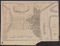
- Published / Created:
- [1767?]
- Call Number:
- 771 N49 1767A
- Container / Volume:
- BRBL_00484
- Image Count:
- 1
- Resource Type:
- Maps, Atlases & Globes
- Found in:
- Beinecke Rare Book and Manuscript Library > Plan of the City of New York ... B. Ratzer ... Thos. kitchin, Sculpt. ...
- Published / Created:
- 1789
- Call Number:
- 32 N83 1789
- Container / Volume:
- BRBL_00052
- Image Count:
- 1
- Resource Type:
- Maps, Atlases & Globes
- Found in:
- Beinecke Rare Book and Manuscript Library > Plan of the City of Norwich ... Engraved by S.J. Neele ...
- Published / Created:
- [1796?]
- Call Number:
- 774 P53 1796
- Container / Volume:
- BRBL_00730
- Image Count:
- 1
- Resource Type:
- Maps, Atlases & Globes
- Found in:
- Beinecke Rare Book and Manuscript Library > Plan of the City of Philadelphia.
- Call Number:
- 779 W27 1792A
- Container / Volume:
- BRBL_00505
- Image Count:
- 1
- Resource Type:
- Maps, Atlases & Globes
- Found in:
- Beinecke Rare Book and Manuscript Library > Plan of the City of Washington in the territory of Columbia. Ceded by the States of Virginia and Maryland to the United States of America and by them established as the Seat of their Government. After the year MDCCC.
- Published / Created:
- [1800?]
- Call Number:
- 779 W27 1800
- Container / Volume:
- BRBL_00505
- Image Count:
- 1
- Resource Type:
- Maps, Atlases & Globes
- Found in:
- Beinecke Rare Book and Manuscript Library > Plan of the City of Washington, in the Territory of Clumbia, ceded by the States of Virginia and Maryland to the United States of America, and by them established as the Seat of their Government, after the year 1800.
- Published / Created:
- 1912
- Call Number:
- 98gbc T535 1912
- Container / Volume:
- BRBL_00679
- Image Count:
- 1
- Resource Type:
- Maps, Atlases & Globes
- Found in:
- Beinecke Rare Book and Manuscript Library > Plan of the Coal MInes Claims : Island of Titicaca, Bolivia.
- Published / Created:
- [1850?]
- Call Number:
- 787hc Sa91 1779
- Container / Volume:
- BRBL_00517A
- Image Count:
- 1
- Resource Type:
- Maps, Atlases & Globes
- Found in:
- Beinecke Rare Book and Manuscript Library > Plan of the French and American Sieg. of Savannah in Georgia in South America under Command of the Frenc Gener. Count d'Estaing. The Britt: Commander in the town was General August Prevost. 1779.
- Published / Created:
- 1760
- Call Number:
- 36hc W19 1760
- Container / Volume:
- BRBL_00134
- Image Count:
- 1
- Resource Type:
- Maps, Atlases & Globes
- Found in:
- Beinecke Rare Book and Manuscript Library > Plan of the March of the Allied Army ... in the battle of Warburg.
- Creator:
- Searl, S. W., cartographer
- Published / Created:
- [1863]
- Call Number:
- BrSides Folio 2014 10
- Image Count:
- 2
- Resource Type:
- cartographic image
- Found in:
- Beinecke Rare Book and Manuscript Library > Plan of the New Haven City burial ground
- Creator:
- Messrs. Carrere & Hastings
- Published / Created:
- 1900-01-30
- Call Number:
- Yh10 +A12
- Collection Title:
- Yale alumni weekly.
- Image Count:
- 1
- Found in:
- Manuscripts and Archives > Plan of the New yale Square, including the bicentennial buildings.
- Published / Created:
- 1921
- Call Number:
- 54633gfc Ok5 1921
- Container / Volume:
- BRBL_00290
- Image Count:
- 1
- Resource Type:
- Maps, Atlases & Globes
- Found in:
- Beinecke Rare Book and Manuscript Library > Plan of the North West shore of the Okotsk Sea, Kamchatka District, Siberia / C.W. Purington.
- Published / Created:
- 1837
- Call Number:
- 39hc Sa54 1837
- Container / Volume:
- BRBL_00703
- Image Count:
- 1
- Resource Type:
- Maps, Atlases & Globes
- Found in:
- Beinecke Rare Book and Manuscript Library > Plan of the Operations in Spain between the 10th and 16th of March 1837.
- Published / Created:
- 1776
- Call Number:
- 771hc 1776
- Container / Volume:
- BRBL_00714
- Image Count:
- 1
- Resource Type:
- Maps, Atlases & Globes
- Found in:
- Beinecke Rare Book and Manuscript Library > Plan of the Operations of the British army in North America, Commanded by General Howe from the 15th to the 16th Nov. 1776.
- Published / Created:
- 1780
- Call Number:
- 771 Sa71 1780
- Container / Volume:
- BRBL_00491
- Image Count:
- 1
- Resource Type:
- Maps, Atlases & Globes
- Found in:
- Beinecke Rare Book and Manuscript Library > Plan of the Position wich the Army under Lt. Genl. Burgoine took Saratoga on the 10th of September 1777, and in which it remained till The Convention was signed.
- Creator:
- Broughton, William Robert, 1762-1821
- Published / Created:
- 1st. Novr. 1798.
- Call Number:
- 846 C72 1798
- Container / Volume:
- BRBL_00622
- Image Count:
- 1
- Resource Type:
- Maps, Atlases & Globes
- Found in:
- Beinecke Rare Book and Manuscript Library > Plan of the River Oregan, from an actual survey.
- Published / Created:
- 1787
- Call Number:
- 786hc C38 1787
- Container / Volume:
- BRBL_00516
- Image Count:
- 1
- Resource Type:
- Maps, Atlases & Globes
- Found in:
- Beinecke Rare Book and Manuscript Library > Plan of the Siege of Charlestown in South Carolina.
- Call Number:
- 59 C126 1890
- Container / Volume:
- BRBL_00318
- Image Count:
- 1
- Resource Type:
- Maps, Atlases & Globes
- Found in:
- Beinecke Rare Book and Manuscript Library > Plan of the Town of Calcutta.
- Published / Created:
- 1830
- Call Number:
- 764 C74 1830
- Container / Volume:
- BRBL_00456A
- Image Count:
- 1
- Resource Type:
- Maps, Atlases & Globes
- Found in:
- Beinecke Rare Book and Manuscript Library > Plan of the Town of Concord, Mass. Surveyed by John G. Hales
- Published / Created:
- [1820?]
- Call Number:
- 774 P83 1820
- Container / Volume:
- BRBL_00714
- Image Count:
- 1
- Resource Type:
- Maps, Atlases & Globes
- Found in:
- Beinecke Rare Book and Manuscript Library > Plan of the Town of Port Clinton at the Forks of Schuylkill. C.G. Childs lith. Phila.
- Published / Created:
- [1798]
- Call Number:
- 734 B797 1798
- Container / Volume:
- BRBL_00709
- Image Count:
- 1
- Resource Type:
- Maps, Atlases & Globes
- Found in:
- Beinecke Rare Book and Manuscript Library > Plan of the Township of Broughton surveyed by Order of Samuel Holland Esq. Surveyor General of Lower and Upper Canada. By Christopher S. Bailley, Dept. Provinl. Surr.
- Published / Created:
- 1822
- Call Number:
- 761 R453 1822
- Container / Volume:
- BRBL_00710
- Image Count:
- 1
- Resource Type:
- Maps, Atlases & Globes
- Found in:
- Beinecke Rare Book and Manuscript Library > Plan of the Township of Ketcham now Riley Lying in the county of Oxford and District (State) of Maine ... by Jas Finlayson.
- Published / Created:
- Circa 1884-1887
- Call Number:
- RU 703
- Container / Volume:
- Box 2, folder 43
- Image Count:
- 3
- Found in:
- Manuscripts and Archives > Yale University buildings and grounds photographs (RU 703) > Series I: Photographs and drawings > Proposals and plans for Yale College (prints of) > Plan of the University, proposed
- Published / Created:
- 1842 Jan
- Call Number:
- Za Em34 840b
- Collection Title:
- The Dial : a magazine for literature, philosophy, and religion / To be continued quarterly. No. 1
- Container / Volume:
- v. 7
- Image Count:
- 12
- Found in:
- Beinecke Rare Book and Manuscript Library > Plan of the West Roxbury community
- Published / Created:
- [1864?]
- Call Number:
- 754hc 1864C
- Container / Volume:
- BRBL_00421
- Image Count:
- 1
- Resource Type:
- Maps, Atlases & Globes
- Found in:
- Beinecke Rare Book and Manuscript Library > Plan of the Western Seat of War. J. Manouvrier & Co., lith., N[ew] O[rleans].
- Published / Created:
- Circa 1865/1880
- Call Number:
- Yca 769 Si3s
- Collection Title:
- Benjamin Silliman by John F Fulton and Elizabeth H Thomson.
- Image Count:
- 1
- Found in:
- Manuscripts and Archives > Plan of the Yale College grounds some years after Silliman's death.
- Published / Created:
- 1784
- Call Number:
- 771hc H864 1777A
- Container / Volume:
- BRBL_00495
- Image Count:
- 1
- Resource Type:
- Maps, Atlases & Globes
- Found in:
- Beinecke Rare Book and Manuscript Library > Plan of the attack of the forts Clinton & Montgomery, upon Hudson's river, which were stormed by his majesty's forces, under the command of Sir Henry Clinton, K.B., on the 6th of Octr., 1777. Drawn from the surveys of Verplank, Holland & Metcalfe. By John
- Creator:
- Linnard, T. B
- Published / Created:
- [1847?]
- Call Number:
- 88hc 1847D
- Container / Volume:
- BRBL_00649
- Image Count:
- 1
- Resource Type:
- Maps, Atlases & Globes
- Found in:
- Beinecke Rare Book and Manuscript Library > Plan of the battle of Buena-Vista : fought February 22nd and 23rd, 1847 / surveyed by Capt. Linnard & Lieuts. Pope & Franklin, Corps T. Engrs. ; drawn by Capt. T.B. Linnard, Corps of T.E.
- Creator:
- De Lacy, W. W. (Walter Washington), 1819-1892
- Call Number:
- WA MSS 443
- Collection Title:
- Isaac Ingalls Stevens papers
- Container / Volume:
- Box 1 | Folder 29
- Image Count:
- 1
- Resource Type:
- Maps, Atlases & Globes
- Found in:
- Beinecke Rare Book and Manuscript Library > Plan of the battle of Grande Ronde fought Jul 17, 1856.
- Creator:
- Craan, W. B. (Guillaume Benjamin), 1776-1848
- Published / Created:
- 1845
- Call Number:
- 335hc W29 1815A
- Container / Volume:
- BRBL_00087
- Image Count:
- 1
- Resource Type:
- Maps, Atlases & Globes
- Found in:
- Beinecke Rare Book and Manuscript Library > Plan of the battle of Waterloo or Mount St. John : reduced from the large plan of the same battle, made up and published in 1816 / by W.B. Craan, Engineer-Examiner of the Register of Lands of Braband.
- Creator:
- Faden, William, 1749-1836, creator
- Published / Created:
- 1783 January 26
- Call Number:
- 1982 Folio 10
- Image Count:
- 1
- Found in:
- Beinecke Rare Book and Manuscript Library > Plan of the bay, rock and town of Gibraltar : from an actual survey by an officer who was at Gibraltar from 1769 to 1775 : with the works, batteries, and incampment of the Spanish Army on the 19th of Octor. 1782, the position of the combined fleet, and th
- Published / Created:
- 1834
- Call Number:
- 32 B959 1834
- Container / Volume:
- BRBL_00046
- Image Count:
- 1
- Resource Type:
- Maps, Atlases & Globes
- Found in:
- Beinecke Rare Book and Manuscript Library > Plan of the borough of Bury St. Edmund's in the county of Suffolk / R. Payne, surveyor, 1834 ; engraved by S. Hall ...
- Creator:
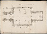
- Miller, Sanderson, 1716-1780, artist
- Published / Created:
- [not after 1780]
- Call Number:
- Drawings M647 no. 13 Box D135
- Image Count:
- 1
- Resource Type:
- still image
- Found in:
- Lewis Walpole Library > Plan of the church at Croome [art original].
- Creator:
- Fosdick, H. M
- Published / Created:
- 1859
- Call Number:
- 834 D437 1859
- Container / Volume:
- BRBL_00589
- Image Count:
- 1
- Resource Type:
- Maps, Atlases & Globes
- Found in:
- Beinecke Rare Book and Manuscript Library > Plan of the cities of Denver, Auraria, and Highland, Jefferson Territory / H.M. Fosdick.
- Creator:
- Horwood, Richard
- Published / Created:
- 1799
- Call Number:
- 2002 Folio 93
- Image Count:
- 40
- Resource Type:
- Maps, Atlases & Globes
- Found in:
- Beinecke Rare Book and Manuscript Library > Plan of the cities of London and Westminster, the Borough of Southwark, and parts adjoining, shewing every house. By R. Horwood
- Creator:
- Alden, Edward C
- Published / Created:
- 1907
- Call Number:
- 32 Ox1 1907
- Container / Volume:
- BRBL_00053
- Image Count:
- 1
- Resource Type:
- Maps, Atlases & Globes
- Found in:
- Beinecke Rare Book and Manuscript Library > Plan of the city and University of Oxford / compiled by Edward C. Alden, Revised & Corrected Oct 1907.
- Published / Created:
- 1789?]
- Call Number:
- 335 An86 1789
- Container / Volume:
- BRBL_00086
- Image Count:
- 1
- Resource Type:
- Maps, Atlases & Globes
- Found in:
- Beinecke Rare Book and Manuscript Library > Plan of the city and citadel of Antwerp / I. Basire sculpt.
- Creator:
- Faden, William, 1749-1836, engraver
- Published / Created:
- 12 Septemr. 1776.
- Call Number:
- 734 Q31 1776
- Container / Volume:
- BRBL_00380
- Image Count:
- 1
- Resource Type:
- Maps, Atlases & Globes
- Found in:
- Beinecke Rare Book and Manuscript Library > Plan of the city and environs of Quebec, with its siege and blockade by the Americans : from the 8th of December 1775 to the 13th of May 1776 / Engraved by Wm. Faden.
- Creator:
- Robert Sayer and John Bennett (Firm)
- Published / Created:
- 1779
- Call Number:
- 1977 Folio 78
- Collection Title:
- A New and accurate chart of the West-India Islands and coast, with the gulf passage through the New
- Image Count:
- 1
- Resource Type:
- Maps, Atlases & Globes
- Found in:
- Beinecke Rare Book and Manuscript Library > Plan of the city and harbour of Havanna. pl. 23
- Creator:
- Tanesse, I
- Published / Created:
- 1817
- Call Number:
- 795 N47 1817
- Container / Volume:
- BRBL_00522
- Image Count:
- 1
- Resource Type:
- Maps, Atlases & Globes
- Found in:
- Beinecke Rare Book and Manuscript Library > Plan of the city and suburbs of New Orleans : from an actual survey made in 1815 / by I. Tanesse ; Rollinson, sc.
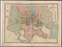
- Published / Created:
- 1836
- Call Number:
- 777 B21 1836
- Container / Volume:
- BRBL_00503
- Image Count:
- 1
- Resource Type:
- Maps, Atlases & Globes
- Found in:
- Beinecke Rare Book and Manuscript Library > Plan of the city of Baltimore, compiled from actual survey by Fielding Lucas Jr.
- Creator:
- Buenos Aires (Argentina). Dept. of Public Works
- Published / Created:
- 1910
- Call Number:
- 94 B86 1910
- Container / Volume:
- BRBL_00675
- Image Count:
- 1
- Resource Type:
- Maps, Atlases & Globes
- Found in:
- Beinecke Rare Book and Manuscript Library > Plan of the city of Buenos Aires, capital of the Argentine Republic [cartographic material] : with the general deliniation of squares / Department of Public Works of the municipality.
- Creator:
- Sandusky, William H
- Published / Created:
- 1845
- Call Number:
- 796 G139 1845B
- Container / Volume:
- BRBL_00527A
- Image Count:
- 1
- Resource Type:
- Maps, Atlases & Globes
- Found in:
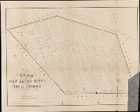
- Beinecke Rare Book and Manuscript Library > Plan of the city of Galveston, Texas / by William H. Sandusky ; lith. by Wagner and McGuigan.
- Creator:
- D. St. John and N. Goodwin, creator.
- Published / Created:
- {1824?]
- Call Number:
- 766 H26 1824A
- Container / Volume:
- BRBL_00468
- Image Count:
- 1
- Resource Type:
- Maps, Atlases & Globes
- Found in:
- Beinecke Rare Book and Manuscript Library > Plan of the city of Hartford : from a survey made in 1824 / engraved by A. Willard.
- Published / Created:
- 1880
- Call Number:
- 766 H26 1880A
- Container / Volume:
- BRBL_00468
- Image Count:
- 1
- Resource Type:
- Maps, Atlases & Globes
- Found in:
- Beinecke Rare Book and Manuscript Library > Plan of the city of Hartford showing sewers.
- Published / Created:
- [1858?]
- Call Number:
- 796 H818 1858
- Image Count:
- 1
- Resource Type:
- Maps, Atlases & Globes
- Found in:
- Beinecke Rare Book and Manuscript Library > Plan of the city of Houston and environs, Texas / drawn by E.F. Gray.