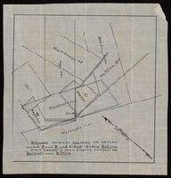
"Magnolia adversed Ypsilanti on conflicts marked A and B, and did not adverse Bullion. Piece marked C is in dispute between the Ypsilanti and Bullion.", From the Richard H. Rickard Papers., and Title devised by cataloger.
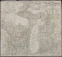
Shows railroads, corporate land ownership, plats of Marquette and Negaunee, sawmill locations in all or parts of sections T.47-48 N, R. 25-27 W.
Description:
Backed with linen. Manuscript annotations on map. Manuscript title on verso: Marquette Iron Region. From the Richard H. Rickard Papers., Coordinates not present on map and are approximated., Detached from: A statement of the plan of the St. Mary's Canal Mineral Land Company (New York : Baker & Godwin, printers, 1859)., and Relief shown by hachures.
Publisher:
[Baker & Godwin, printers],
Subject (Geographic):
Michigan--Upper Peninsula
Subject (Name):
Collins Iron Company--Maps., Excelsior Iron Company--Maps., Jackson Iron Company (Fayette, Mich.)--Maps., Peninsula Iron Company--Maps., Pioneer Iron Company--Maps., and Rickard, Richard H.,---1885--Owner
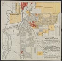
Exposition of the natural position of Mackinaw City.
Container / Volume:
BRBL_00553
Image Count:
1
Resource Type:
Maps, Atlases & Globes
Description:
Elevation shown by spot heights, bathymetry by soundings, in feet., Imperfect: Mutilated with loss of text., Inset: Straits of Mackinaw and vicinity., and Shows property boundaries and proposed railroads and docks.
Publisher:
Middleton, Wallace & Co., lithrs.
Subject (Geographic):
Mackinaw City (Mich.)--Maps
Subject (Name):
De La Vergne, Earl W. pro and Middleton, Wallace & Co