Search
You Searched For
Search Results
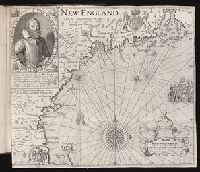
- Creator:
- Pass, Simon van de, 1595?-1647, engraver
Reeve, James, printer.
- Published / Created:
- [1632]
- Call Number:
- Taylor 320
- Collection Title:
- The generall historie of Virginia, New-England, and the Summer Isles : with the names of the
- Image Count:
- 1
- Subject (Geographic):
- New England --History --Colonial period
- Found in:
- Beinecke Rare Book and Manuscript Library > New England.
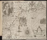
- Creator:
- Clarke, Robert, fl. 1616
Pass, Simon van de, 1595?-1647, engraver.
Reeve, James, printer.
- Published / Created:
- [1632]
- Call Number:
- Vanderbilt +145
- Collection Title:
- The generall historie of Virginia, New-England, and the Summer Isles : with the names of the
- Image Count:
- 1
- Subject (Geographic):
- New England --History --Colonial period
- Found in:
- Beinecke Rare Book and Manuscript Library > New England.
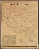
- Published / Created:
- 1871
- Call Number:
- 761 B98 1870
- Container / Volume:
- BRBL_00448
- Image Count:
- 1
- Resource Type:
- Maps, Atlases & Globes
- Publisher:
- New England Lith. Co. ,
- Found in:
- Beinecke Rare Book and Manuscript Library > Map of Buxton, Maine / by Daniel Dennet, 1870.
- Published / Created:
- [1774]
- Call Number:
- 76 1774
- Container / Volume:
- BRBL_00729
- Image Count:
- 1
- Resource Type:
- Maps, Atlases & Globes
- Abstract:
- Subject: Map of New England and Long
- Subject (Geographic):
- New England--Maps
- Found in:
- Beinecke Rare Book and Manuscript Library > A Map of the most inhabited part of New England [cartographic material] : containing the provinces of Massachusets Bay and New Hampshire with the colonies of Conecticut and Rhode Island divided into counties and townships : The whole composed from actual
- Published / Created:
- [1774]
- Call Number:
- 76 1774
- Container / Volume:
- BRBL_00729
- Image Count:
- 2
- Resource Type:
- Maps, Atlases & Globes
- Abstract:
- Subject: Map of New England and Long
- Subject (Geographic):
- New England--Maps
- Found in:
- Beinecke Rare Book and Manuscript Library > A Map of the most inhabited part of New England [cartographic material] : containing the provinces of Massachusets Bay and New Hampshire with the colonies of Conecticut and Rhode Island divided into counties and townships : The whole composed from actual
- Published / Created:
- [1774]
- Call Number:
- 76 1774
- Container / Volume:
- BRBL_00443
- Image Count:
- 2
- Resource Type:
- Maps, Atlases & Globes
- Abstract:
- Subject: Map of New England and Long
- Subject (Geographic):
- New England--Maps
- Found in:
- Beinecke Rare Book and Manuscript Library > A Map of the most inhabited part of New England [cartographic material] : containing the provinces of Massachusets Bay and New Hampshire with the colonies of Conecticut and Rhode Island divided into counties and townships : The whole composed from actual
- Creator:
- From the Collection: New England Grenfell Association
- Published / Created:
- 1912-1977
- Call Number:
- MS 1200
- Container / Volume:
- Box 5, folder 51
- Image Count:
- 1
- Found in:
- Manuscripts and Archives > New England Grenfell Association records (MS 1200) > Series I: Office Files > Memorabilia
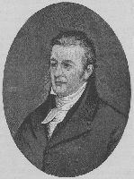
- Published / Created:
- circa 1750-2001
- Call Number:
- RU 684
- Container / Volume:
- Box 34, folder 1239
- Image Count:
- 1
- Found in:
- Manuscripts and Archives > Images of Yale individuals (RU 684) > Series I: Alphabetical List of Individuals > Hopkins, Samuel Miles (1791)
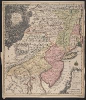
- Creator:
- Lotter, Tobias Conrad, 1717-1777
- Published / Created:
- 1760?]
- Call Number:
- 755 1760E
- Container / Volume:
- BRBL_00428
- Image Count:
- 1
- Resource Type:
- Maps, Atlases & Globes
- Description:
- Also covers New England (distorted) and
- Subject (Geographic):
- New England--Maps--Early works to 1800
- Found in:
- Beinecke Rare Book and Manuscript Library > Pensylvania, Nova Jersey et Nova York cum regionibus ad Fluvium Delaware in America sitis / nova delineatione ob oculos posita per Tob. Conr. Lotter, geographum Aug. Vind. ; Tob. Conr. Lotter sculps. Aug. V.