Search
You Searched For
Search Results
- Published / Created:
- [not before 1793]
- Call Number:
- 785.11.09.02
- Image Count:
- 1
- Resource Type:
- still image
- Found in:
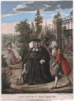
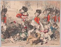
- Lewis Walpole Library > A master parson returned from duty [graphic].
- Published / Created:
- 9 Novr. 1785.
- Call Number:
- 785.11.09.01+
- Image Count:
- 1
- Resource Type:
- still image
- Found in:
- Lewis Walpole Library > A master parson returned from duty [graphic].
- Published / Created:
- May 1812.
- Call Number:
- Quarto 75 D569 812
- Collection Title:
- Leaf 54. Characatures by Dighton.
- Image Count:
- 1
- Resource Type:
- still image
- Found in:
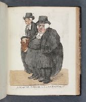
- Lewis Walpole Library > A master parson & his journeyman [graphic].
- Published / Created:
- May 1812.
- Call Number:
- 812.05.00.01 Impression 1
- Collection Title:
- Leaf 54. Characatures by Dighton.
- Image Count:
- 1
- Resource Type:
- still image
- Found in:
- Lewis Walpole Library > A master parson & his journeyman [graphic].
- Creator:
- Rowlandson, Thomas, 1756-1827, printmaker.
- Published / Created:
- 1795 Novemebr 24
- Call Number:
- Auchincloss Rowlandson v. 4
- Image Count:
- 1
- Found in:
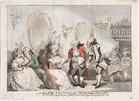
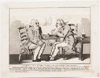
- Beinecke Rare Book and Manuscript Library > A master of the ceremonies introducing a partner [graphic] / T. Rowlandson.
- Creator:
- Rowlandson, Thomas, 1756-1827, printmaker
- Published / Created:
- [24 November 1795]
- Call Number:
- 795.11.24.01+
- Image Count:
- 1
- Resource Type:
- still image
- Found in:
- Lewis Walpole Library > A master of the ceremonies introducing a partner [graphic]
- Creator:
- Gillray, James, 1756-1815, printmaker.
- Published / Created:
- 1803 January 10
- Call Number:
- Auchincloss Gillray v. 11
- Image Count:
- 1
- Found in:
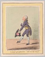
- Beinecke Rare Book and Manuscript Library > A master of ceremonies [graphic] : sketch'd at the castle, Richmond.
- Published / Created:
- [4 April 1795]
- Call Number:
- 795.04.04.01 Impression 1
- Image Count:
- 1
- Resource Type:
- still image
- Found in:
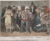
- Lewis Walpole Library > A masquerade [graphic].
- Published / Created:
- [1 December 1803]
- Call Number:
- 803.12.01.02
- Image Count:
- 1
- Resource Type:
- still image
- Found in:
- Lewis Walpole Library > A marvellous story, or, The advantage of travelling [graphic].
- Creator:
- Maigne, C. M
- Call Number:
- WA Photos 307
- Collection Title:
- Postcard photographs related to United States military involvement in the Mexican Revolution
- Container / Volume:
- Folder 6
- Image Count:
- 2
- Found in:
- Beinecke Rare Book and Manuscript Library > A marine is signaling as to where to open fire
- Creator:
- Gillray, James, 1756-1815, printmaker
- Published / Created:
- [22 August 1787]
- Call Number:
- Drawer 787.08.22.01
- Image Count:
- 1
- Resource Type:
- still image
- Found in:
- Lewis Walpole Library > A march to the bank vide the Strand, Fleet Street, Cheapside &c. morning & evening. [graphic]
- Creator:
- Gillray, James, 1756-1815, printmaker.
- Published / Created:
- 1787 August 22
- Call Number:
- Auchincloss Gillray v. 7
- Image Count:
- 1
- Found in:
- Beinecke Rare Book and Manuscript Library > A march to the bank [graphic] : vide the Strand, Fleet Street, Cheapside &c. morning & evening.
- Creator:
- Darly, Matthias, approximately 1720-approximately 1778, printmaker
- Published / Created:
- [10 April 1777]
- Call Number:
- 777.04.10.01+
- Image Count:
- 1
- Resource Type:
- still image
- Found in:
- Lewis Walpole Library > A march of the train bands [graphic]
- Published / Created:
- 1734
- Call Number:
- 771 N49 1734
- Container / Volume:
- BRBL_00713
- Image Count:
- 1
- Resource Type:
- Maps, Atlases & Globes
- Found in:
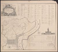
- Beinecke Rare Book and Manuscript Library > A mapp or survey of the swamp or Crupel-bush in Montgomerie Ward in the city of New York ... 1734. Copied ... 1823, 1830 ... 1899 by W.F. Osborne.
- Call Number:
- 1977 +392
- Collection Title:
- A survey of the cities of London and Westminster : containing the original, antiquity, increase
- Image Count:
- 1
- Resource Type:
- Maps, Atlases & Globes
- Found in:
- Beinecke Rare Book and Manuscript Library > A mapp of the parishes of St. Saviours Southwark and St. Georges taken from the last survey with corrections
- Call Number:
- 1977 +392
- Collection Title:
- A survey of the cities of London and Westminster : containing the original, antiquity, increase
- Image Count:
- 1
- Resource Type:
- Maps, Atlases & Globes
- Found in:
- Beinecke Rare Book and Manuscript Library > A mapp of the parishes of St. Clements Danes, St. Mary Savoy; with the Rolls Liberty and Lincolns Inn, taken from the last survey with corrections and additions
- Call Number:
- 1977 +392
- Collection Title:
- A survey of the cities of London and Westminster : containing the original, antiquity, increase
- Image Count:
- 1
- Found in:
- Beinecke Rare Book and Manuscript Library > A mapp of the parish of St. Giles's in the Fields taken from the last servey, with corrections and additions
- Published / Created:
- [17--?]
- Call Number:
- 39 C11 1702
- Container / Volume:
- BRBL_00189
- Image Count:
- 1
- Resource Type:
- Maps, Atlases & Globes
- Found in:
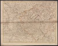
- Beinecke Rare Book and Manuscript Library > A mapp of the bay and towne of Cadiz : with all it's fortifications as it was ye 15th. of August 1702, at the time of Sr. George Rooke's coming before it / H. Hulsbergh, scu.
- Creator:
- Berry, William, fl. 1669-1708, creator
Sanson, Nicolas, 1600-1667
- Published / Created:
- 1680
- Call Number:
- 1973 Folio 10
- Image Count:
- 1
- Resource Type:
- Maps, Atlases & Globes
- Found in:
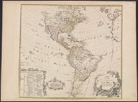
- Beinecke Rare Book and Manuscript Library > A mapp of all the world in two hemispheres in which are exactly described all the parts of the earth and seas
- Creator:
- Thornton, John, fl. 1652-1701
- Published / Created:
- [1673?]
- Call Number:
- 755 1682B
- Container / Volume:
- BRBL_00424
- Image Count:
- 1
- Resource Type:
- Maps, Atlases & Globes
- Found in:
- Beinecke Rare Book and Manuscript Library > A mapp of Virginia, Mary-land, New-Jarsey, New-York, & New England.
- Creator:
- Seller, John, fl. 1658-1698
- Published / Created:
- [1675]
- Call Number:
- 76 1675
- Image Count:
- 1
- Resource Type:
- Maps, Atlases & Globes
- Found in:
- Beinecke Rare Book and Manuscript Library > A mapp of New England / by John Seller, hydrographer to the King.
- Published / Created:
- 1803
- Call Number:
- 771 1803
- Container / Volume:
- BRBL_00477
- Image Count:
- 1
- Resource Type:
- Maps, Atlases & Globes
- Found in:
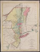
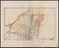
- Beinecke Rare Book and Manuscript Library > A map showing the relative situation of a trct of land belonging to I.B. Church Esqr. situated on the Genesee River in Western New York State.
- Published / Created:
- between 1920 and 1949
- Call Number:
- RG 11
- Collection Title:
- Archives of the United Board for Christian Higher Education in Asia
- Container / Volume:
- Box 419 | Folder 5890
- Image Count:
- 1
- Resource Type:
- Prints & Photographs
- Found in:
- Yale Divinity Library > A map showing the levels of iodine in drinking water in northern China
- Call Number:
- 735 1790
- Container / Volume:
- BRBL_00689
- Image Count:
- 1
- Resource Type:
- Maps, Atlases & Globes
- Found in:
- Beinecke Rare Book and Manuscript Library > A map shewing the communication of the lakes and the rivers between Lake Superior and Slave Lake in North America.
- Published / Created:
- [1684?]
- Call Number:
- 755 1684A
- Container / Volume:
- BRBL_00424
- Image Count:
- 1
- Resource Type:
- Maps, Atlases & Globes
- Found in:
- Beinecke Rare Book and Manuscript Library > A map of ye English Empire in Y Continent of America, ... W. Binneman, sculpsit.
- Creator:
- Delarochette, L. (Louis), 1731-1802
- Published / Created:
- 17--?]
- Call Number:
- 70 1770
- Container / Volume:
- BRBL_00356
- Image Count:
- 1
- Resource Type:
- Maps, Atlases & Globes
- Found in:
- Beinecke Rare Book and Manuscript Library > A map of the whole continent of America : according to D'Anville & Bellin / by L. Delarochette ; Bayly, sculpt.
- Published / Created:
- 1836
- Call Number:
- 764 T193 1836
- Container / Volume:
- BRBL_00460
- Image Count:
- 1
- Resource Type:
- Maps, Atlases & Globes
- Found in:
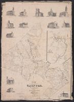
- Beinecke Rare Book and Manuscript Library > A map of the town of Tounton : with a view of the public buildilngs / published by Saml. O. Dunbar, Tounton, 1836.
- Published / Created:
- [1752]
- Call Number:
- BrSides 2019 81
- Image Count:
- 1
- Resource Type:
- Maps, Atlases & Globes
- Found in:
- Beinecke Rare Book and Manuscript Library > A map of the terrestrial Paradise according to Mr. Huet / with improvements from Dr. Wells.
- Creator:
- Purcell, Joseph (Cartographer)
- Published / Created:
- 1792
- Call Number:
- 755 1792A
- Container / Volume:
- BRBL_00435
- Image Count:
- 1
- Resource Type:
- Maps, Atlases & Globes
- Found in:
- Beinecke Rare Book and Manuscript Library > A map of the states of Virginia, North Carolina, South Carolina and Georgia [cartographic material] : comprehending the Spanish provinces of east and west Florida : exhibiting the boundaries as fixed by the late treaty of peace between the United States a
- Creator:
- Purcell, Joseph (Cartographer)
- Published / Created:
- 1788
- Call Number:
- BrSides Folio 2017 122
- Image Count:
- 1
- Resource Type:
- Maps, Atlases & Globes
- Found in:
- Beinecke Rare Book and Manuscript Library > A map of the states of Virginia, North Carolina, South Carolina and Georgia [cartographic material] : comprehending the Spanish provinces of East and West Florida, exhibiting the boundaries as fixed by the late treaty of peace between the United States an
- Creator:
- Purcell, Joseph (Cartographer)
- Published / Created:
- 1788
- Call Number:
- 755 1788
- Container / Volume:
- BRBL_00435
- Image Count:
- 1
- Resource Type:
- Maps, Atlases & Globes
- Found in:
- Beinecke Rare Book and Manuscript Library > A map of the states of Virginia, North Carolina, South Carolina and Georgia [cartographic material] : comprehending the Spanish provinces of East and West Florida, exhibiting the boundaries as fixed by the late treaty of peace between the United States an
- Creator:
- Howell, Reading, 1743-1827
- Published / Created:
- 1816
- Call Number:
- 774 1816
- Container / Volume:
- BRBL_00498
- Image Count:
- 1
- Resource Type:
- Maps, Atlases & Globes
- Found in:
- Beinecke Rare Book and Manuscript Library > A map of the state of Pennsylvania / [cartographic material] / by Reading Howell, MDCCCXVI ; published by Emmor Kimber.
- Creator:
- Howell, Reading, 1743-1827
- Published / Created:
- 1811
- Call Number:
- 774 1811
- Container / Volume:
- BRBL_00498
- Image Count:
- 1
- Resource Type:
- Maps, Atlases & Globes
- Found in:
- Beinecke Rare Book and Manuscript Library > A map of the state of Pennsylvania / [cartographic material] / by Reading Howell, MDCCCXI ; engraved by J. Vallance.
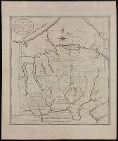
- Published / Created:
- 1793
- Call Number:
- CF352 I54 1793
- Collection Title:
- The discovery, settlement, and present state of Kentucky: and an essay towards the topography and
- Image Count:
- 1
- Found in:
- Beinecke Rare Book and Manuscript Library > A map of the state of Kentucky, drawn from the best authorities
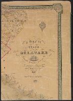
- Creator:
- Price, Jacob, fl. 1850
- Published / Created:
- 1850
- Call Number:
- 776 1850
- Container / Volume:
- BRBL_00502
- Image Count:
- 4
- Resource Type:
- Maps, Atlases & Globes
- Found in:
- Beinecke Rare Book and Manuscript Library > A map of the state of Delaware / [cartographic material] / from original surveys of Jacob Price & Samuel M. Rea, assisted by H. Paxon.
- Creator:
- Faden, William, 1749-1836, creator
- Published / Created:
- 1789 January 1
- Call Number:
- 1982 Folio 10
- Image Count:
- 1
- Found in:
- Beinecke Rare Book and Manuscript Library > A map of the seven united provinces, with the land of Drent, and the generality Lands
- Creator:
- Berry, W
Morden, R.
- Published / Created:
- 1688
- Call Number:
- 1976 1233
- Collection Title:
- Twenty four new and accurate maps of the several parts of Europe ... : all (except the last) new
- Image Count:
- 1
- Found in:
- Beinecke Rare Book and Manuscript Library > A map of the sea coast of England France and Holland ...
- Published / Created:
- 1713]
- Call Number:
- 38 P21 1713
- Container / Volume:
- BRBL_00160
- Image Count:
- 1
- Resource Type:
- Maps, Atlases & Globes
- Found in:
- Beinecke Rare Book and Manuscript Library > A map of the provostship and vicounty of Paris.
- Creator:
- L'Isle, Guillaume de, 1675-1726
- Published / Created:
- 1713
- Call Number:
- 38 1713
- Container / Volume:
- BRBL_00684
- Image Count:
- 1
- Resource Type:
- Maps, Atlases & Globes
- Found in:
- Beinecke Rare Book and Manuscript Library > A map of the provostship and vicounty of Paris [cartographic material] : drawn from a great number of particular memoirs made according to the observations of the Royal Academy of Sciences / by G Delisle ...
- Published / Created:
- 1777
- Call Number:
- 755 1777S
- Container / Volume:
- BRBL_00728
- Image Count:
- 1
- Resource Type:
- Maps, Atlases & Globes
- Found in:
- Beinecke Rare Book and Manuscript Library > A map of the provinces of New-York and New-Jersey ... from the topographical observations of C.J. Sauthier / engraved ... by Matthew Albert Lotter.
- Published / Created:
- 1777
- Call Number:
- 755 1777J
- Container / Volume:
- BRBL_00431
- Image Count:
- 2
- Resource Type:
- Maps, Atlases & Globes
- Found in:
- Beinecke Rare Book and Manuscript Library > A map of the provinces of New York and New Jersey, with a part of Pennsylvania and the Province of Quebec ...
- Creator:
- Jefferys, Thomas, d. 1771
- Call Number:
- Z6 70
- Collection Title:
- An enquiry into the causes of the alienation of the Delaware and Shawanese Indians from the British
- Image Count:
- 1
- Found in:
- Beinecke Rare Book and Manuscript Library > A map of the province of Pensylvania. intended chiefly to illustrate the account of the several Indian purchases made by the proprietaries of the said province the claims made by the Indians, on lands settled and not purchased of them and the tract they n
- Published / Created:
- 1870
- Call Number:
- 774 1870H
- Container / Volume:
- BRBL_00730
- Image Count:
- 4
- Resource Type:
- Maps, Atlases & Globes
- Found in:
- Beinecke Rare Book and Manuscript Library > A map of the province of Pennsilvania ... / by Thomas Holme ...
- Creator:
- Faden, William, 1749-1836
- Published / Created:
- 1795 [i.e. 1800] and London :
- Call Number:
- 59 1800
- Container / Volume:
- BRBL_00316
- Image Count:
- 2
- Resource Type:
- Maps, Atlases & Globes
- Found in:
- Beinecke Rare Book and Manuscript Library > A map of the peninsula of India from the 19th degree north latitude to Cape Comorin, MDCCXCII / B. Baker, sculp.
- Call Number:
- 1977 +392
- Collection Title:
- A survey of the cities of London and Westminster : containing the original, antiquity, increase
- Image Count:
- 1
- Resource Type:
- Maps, Atlases & Globes
- Found in:
- Beinecke Rare Book and Manuscript Library > A map of the parish of St. Dustans Stepney and Stebunheath divided into hamlets
- Call Number:
- 1977 +392
- Collection Title:
- A survey of the cities of London and Westminster : containing the original, antiquity, increase
- Image Count:
- 1
- Resource Type:
- Maps, Atlases & Globes
- Found in:
- Beinecke Rare Book and Manuscript Library > A map of the parish if St. Katherines by the Tower
- Published / Created:
- [1792?]
- Call Number:
- 755 1792
- Container / Volume:
- BRBL_00435
- Image Count:
- 1
- Resource Type:
- Maps, Atlases & Globes
- Found in:
- Beinecke Rare Book and Manuscript Library > A map of the northern and middle states comprehending the western territory and the British dominions in North America ... Delineated & Eng. by Amos Doolittle, New Haven.
- Call Number:
- 783 1775
- Container / Volume:
- BRBL_00507
- Image Count:
- 3
- Resource Type:
- Maps, Atlases & Globes
- Found in:
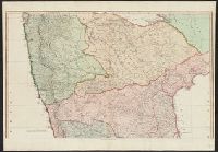
- Beinecke Rare Book and Manuscript Library > A map of the most inhabited part of Virginia part of Pensilvania, new Yersey & North Carolina.
- Creator:
- Fry, Joshua, 1700 (ca.)-1754, creator
Halifax, George Montagu-Dunk, Earl of, 1716-1771
Jefferson, Peter, 1708-1757
Jefferys, Thomas, d. 1771
- Published / Created:
- [1755]
- Call Number:
- 2003 Folio 85
- Image Count:
- 1
- Found in:
- Beinecke Rare Book and Manuscript Library > A map of the most inhabited part of Virginia containing the whole province of Maryland: with part of Pensilvania, New Jersey and North Carolina
- Creator:
- Fry, Joshua, approximately 1700-1754
- Published / Created:
- 1794
- Call Number:
- 783 1794
- Container / Volume:
- BRBL_00507
- Image Count:
- 1
- Resource Type:
- Maps, Atlases & Globes
- Found in:
- Beinecke Rare Book and Manuscript Library > A map of the most inhabited part of Virginia containing the whole province of Maryland with part of Pensilvania, New Jersey and North Carolina / drawn by Joshua Fry & Peter Jefferson in 1775.
- Creator:
- Jefferys, Thomas, -1771, printmaker.
- Published / Created:
- 1755
- Call Number:
- 783 1755F
- Container / Volume:
- BRBL_00507
- Image Count:
- 1
- Resource Type:
- Maps, Atlases & Globes
- Found in:
- Beinecke Rare Book and Manuscript Library > A map of the most inhabited part of Virginia containing the whole province of Maryland with part of Pensilvania, New Jersey and North Carolina / drawn by Joshua Fry & Peter Jefferson in 1751.
- Creator:
- Jefferys, Thomas, d. 1771, creator
Mellon, Paul
- Published / Created:
- November 29th 1755
- Call Number:
- 2003 Folio 85
- Image Count:
- 1
- Found in:
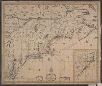
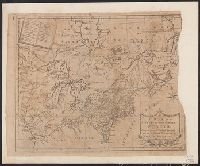
- Beinecke Rare Book and Manuscript Library > A map of the most inhabited part of New England: containing the provinces of Massachusets Bay and New Hampshire, with the colonies of Conecticut and Rhode Island : divided into counties and townships : the whole composed from actual surveys and its situat
- Published / Created:
- 1774 November 29
- Call Number:
- 1975 Folio 51
- Collection Title:
- The American atlas; or, A geographical description of the whole continent of America; wherein are
- Image Count:
- 1
- Resource Type:
- Maps, Atlases & Globes
- Found in:
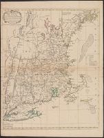
- Beinecke Rare Book and Manuscript Library > A map of the most inhabited part of New England, containing the provinces of Massachusets Bay and New Hampshire, with the colonies of Conecticut and Rhode Island, divided into counties and townships: the whole composed from actual surveys and its situatio
- Creator:
- Jefferys, Thomas, -1771.
- Published / Created:
- November 29th 1755.
- Call Number:
- 76 1755A
- Container / Volume:
- BRBL_00443
- Image Count:
- 2
- Resource Type:
- Maps, Atlases & Globes
- Found in:
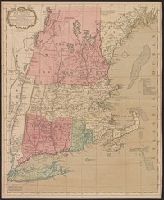
- Beinecke Rare Book and Manuscript Library > A map of the most inhabited part of New England : containing the provinces of Massachusetts Bay and New Hampshire, with the colonies of Konektikut and Rhode Island, divided into counties and townships: The whole composed from actual surveys and its situat
- Published / Created:
- 1771
- Call Number:
- 76 1771
- Container / Volume:
- BRBL_00443
- Image Count:
- 1
- Resource Type:
- Maps, Atlases & Globes
- Found in:
- Beinecke Rare Book and Manuscript Library > A map of the most inhabited part of New England ...
- Published / Created:
- 1771
- Call Number:
- 76 1771
- Container / Volume:
- BRBL_00443
- Image Count:
- 1
- Resource Type:
- Maps, Atlases & Globes
- Found in:
- Beinecke Rare Book and Manuscript Library > A map of the most inhabited part of New England ...
- Published / Created:
- [1760?]
- Call Number:
- 76 1760
- Container / Volume:
- BRBL_00443
- Image Count:
- 1
- Resource Type:
- Maps, Atlases & Globes
- Found in:
- Beinecke Rare Book and Manuscript Library > A map of the most inhabited part of New England ...
- Creator:
- Robinson, W. W. (William Wilcox), 1891-1972
- Published / Created:
- c1956.
- Call Number:
- 844ag 1956
- Container / Volume:
- BRBL_00612
- Image Count:
- 2
- Resource Type:
- Maps, Atlases & Globes
- Found in:
- Beinecke Rare Book and Manuscript Library > A map of the missions, presidios, pueblos, and some of the more interesting ranchos of Spanish California : together with the routes of the principal land explorations therein / compiled by W.W. Robinson and William H. Newbro, Jr. ; edited by Phil Townsen
- Published / Created:
- ca. 1790
- Call Number:
- BrSides Folio 2017 98
- Image Count:
- 2
- Found in:
- Beinecke Rare Book and Manuscript Library > A map of the military lands and 20 townships in the western part of the state of New York.