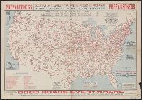
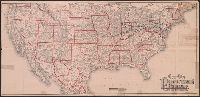
"Issued under the joint auspices of the National Highways Association." and "This map shows tentative locations for a system of 100,000 miles of national highways."
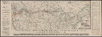
"Fall, 1883, September"--Panel., Covers northern United States and a portion of southern Canada., Main railroad lines indicated by heavy black and red., Shows national, state and provincial boundaries, railroads, cities an, and Timetables, text and ill. on verso.
Publisher:
Northern Pacific Railway,
Subject (Name):
Northern Pacific Railroad Company--Maps, Northern Pacific Railroad Company--Timetables, and Rand McNally and Company
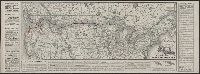
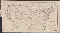
"Summer,, Covers northern United States and a portion of southern Canada., Main railroad lines indicated by heavy black and red., Shows national, state and provincial boundaries, railroads, cities and towns, drainage, etc., and Timetables, text and ill. on verso.
Publisher:
Northern Pacific Railway,
Subject (Name):
Northern Pacific Railroad Company--Maps, Northern Pacific Railroad Company--Timetables, and Rand McNally and Company
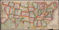
General map of the Pennsylvania Railroad and its connections.
Description:
Inset: Round the World , Across the American Continent, via the Pennsylvania Railroad. and Text and tables on verso: Pennsylvania Railroad Great Trunk Line and U.S. Mail Route, July, 1880.
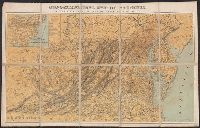
Each sheet is colored to show rocks from one or two geologic eras only., In upper border: U.S. Geological Survey. Fourteenth annual report, pl. II., Includes legend., Relief shown by contour lines., and Shows Indian reservations.
Publisher:
U.S. Geological Survey,
Subject (Name):
Bien, Julius, 1826-1909 and Geological Survey (U.S.)
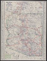
Also covers Washington, D.C., and parts of New Jersey, North Carolina, Kentucky and Pennsylvania., Includes list of "Altitudes of Mountains"., Inset map: Railroad ma, and Shows state and county boundaries, names of cities and towns, rivers, roads, and railroads.
Publisher:
Jacob Weiss lith.,
Subject (Geographic):
Delaware--Maps, Maryland--Maps, and Virginia--Maps