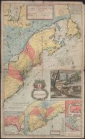
[South part of Carolina, and the east part of Florida], Draught of ye town and harbour of Charles-town, Map of the improved part of Carolina with the settlements, Map of the principal part of North America, and View of ye industry of ye beavers of Canada
Description:
Hand colored.
Publisher:
Printed and sold by Tho. Bowles ...,
Subject (Geographic):
France--Colonies--America--Maps--Early works to 1800, Great Britain--Colonies--America--Maps--Early works to 1800, North America--Maps--Early works to 1800, and United States--History--Colonial period, ca. 1600-1775--Maps--Ear