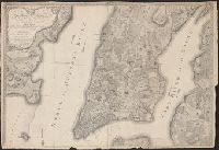
Also shows ward boundaries, portions of nearby cities and locations of some structures., Relief shown by hachures., and Shows Manhattan below 118th Street.
Includes text of Declaration of Independence and index to points of interest., Inset: [Long Island an, Oriented with north upper right corner., and Shows wards, streets, public buildings, ferry routes with distances, and radial distances from New York City Hall.
Copy 2: Hand col., Includes text of Declaration of Independence and index to points, Inset: [Long Island and vicinity.]., Oriented with north upper right corner., and Shows wards, streets, public buildings, ferry routes with distances, and radial distances from N
Includes text of Declaration of Independence and index to points of interest., Inset: [Long Island and vicinity.]., Oriented with north upper right corner., and Shows wards, streets, public buildings, ferry routes with distances, a
To his excellency Sir Henry Moore, Bart., Captain General & Governour in Chief in and over His Majesty's province of New York ... this plan of the city of New York & its environs ... is most humbly dedicated
Description:
"From D.T. Valentine's Manual, 1854.", Facsimile., Includes decorative cartouche and ancillary view, A south west view of the city of New York taken from the Governour's Island at * [i.e. asterisk]., and Relief shown by hachures.
Publisher:
s.n.,
Subject (Geographic):
NewYork (N.Y.)--Maps--Early works to
Subject (Name):
Hayward, George, b. ca. 1800, Kitchin, Thomas, d. 1784, and Valentine, D. T. (David Thomas), 1801-1869. Valentine's manual of old New York. 1854