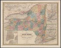
City of New York, with part of Brooklyn and Williamsburg, New-York State guide., St. Lawrence River, from the New York state line to Quebec, and Vicinity of New York, showing the line of the Croton Aqueduct and the Hudson River to Newburg
Description:
"Entered according to Act of Congress in the year 1842 by J. Calvin Smith in the Clerk's Office of the District Court of the southern District of New York." and In: The New-York State guide : containing an alphabetical list of counties, towns, cities, village
From Thomas Jeffery's American atlas. 1778., Imperfect: southern portion of text torn along fold and separated. Sheets pasted together to form one map. No. "17" stamped on verso, upper right corner., Insets: A chart of the mouth of Hudson's River, from Sandy Hook to New York.--A plan of the city of New York.--Plan of Amboy, with its environs, from an actual survey., Prime meridian: London., Relief shown pictorially., Shows administrative divisions., and Watermarks.
Publisher:
Printed for Robt. Sayer & John Bennett ...,
Subject (Geographic):
NewYork (N.Y.)--Maps--Early works to
Subject (Name):
Holland, Samuel, 1728-1801 and Robert Sayer and John Bennett (Firm)