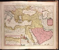
Dominions or empire of the great Turke in Europe, Asia, and Africa ... described by Sanson, corrected and amended by Will. Berry
Description:
Bar scales in Italian miles, common leagues of France, great leagues of France, common leagues of Germany or great leagues of Poland, leagues of Hungary, and Persian leagues of one houres travilling., Dedicated to James II by William Berry., Ferro meridian., No. 50 of 69 maps bound together in composite atlas., Relief shown pictorially., and Scale [ca. 1:8 600 000].
Publisher:
Sold by William Berry at the signe of the Globe between Charing Cross, and White Hall
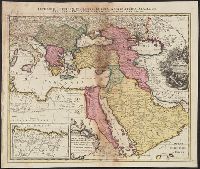
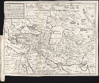
Imperium Turcicum, complectens Europae, Asiae et Africae, Arabiae que regiones ac provincias plurimas, industria et labore Petr. Schenck
Description:
Appeared in Peter Schenk's Atlas contractus., Backed with paper. Ms. no. "91" in upper right-hand corner. Sheet measures 53.6 x 62.5 cm. No. 83 of 87 maps bound together., Includes six bar scales., Inset map [partially obscuring title in cartouche] is continuation of the North African coastline., Prime meridian: Ferro., and Relief shown pictorially.
Publisher:
P. Schenck, avec privil,
Subject (Geographic):
Turkey--Maps--Early works to 1800.
Subject (Name):
Schenk, Peter, 1660-1718 or 1719. Atlas contractus.
Imperium Turcicum, complectens Europae, Asiae et Africae, Arabiae que regiones ac provincias plurimas, industria et labore Sr. Sanson
Description:
Includes four bar scales., Inset map [partially obscuring title in cartouche] is continuation of the North African coastline., Prime meridian: Ferro., Reinforced on back with paper. Sheet measures 51.5 x 61.0 cm., and Relief shown pictorially.
"Ad novam editionem operum Constantini Porphyrogeniti quae prodit studio Anselmi Bandurii, Ragusini monachi Benedictini Melitensis cum ejusdem notis et animadversionibus.", Appears in Anselmo Banduri's Imperium orientale. 1729., and Relief shown pictorially.
Publisher:
Ex typographia Bartholomaei Javarina,
Subject (Geographic):
Turkey--History--Maps--Early works to
Subject (Name):
Banduri, Anselmo Maria, 1675-1743. Imperium orientale. 1729
Covers Greece and western Turkey., Includes text, ill., Relief shown pictorially., Sheet measures 54 x 75 cm., Shows locations mentioned in Herodotus, Thucydides, etc., and Some place names in Latin and Greek.
Broeck, Crispin van den, 1524-ca. 1591 Visscher, Nicolaes, 1618-1679
Published / Created:
[ca. 1660]
Call Number:
1983 Folio 19
Collection Title:
[Atlas factice of 96 maps by Blaeu, Visscher, Jansson, Hondius and others]
Image Count:
2
Alternative Title:
Armenia Maior and Asia et Armenia Minor
Description:
Imperfect: illustrations at top cut-out and replaced with ms. titles "Asia et Armenia minor" (upper left) and "Armenia minor" (in upper right); torn along fold and at left edge, with some loss of text. Sheet measures 32 x 47.8 cm. Reinforced along edges with printed waste. No. 85 of 92 maps bound together. and Numbered 91 on verso.