Skip to search
Skip to main content
Skip to first result
Search
You Searched For
"World War, 1914-1918--Maps"
New Search
Search Results
Creator:
Published / Created:
[1916?]
Call Number:
30ed 1916
Container / Volume:
BRBL_00037B
Image Count:
1
Resource Type:
Maps, Atlases & Globes
Description:
Includes statistical charts.
Publisher:
Stanford's Geographical Establishment,
Subject (Geographic):
Eurasia--Administrative and political divisions--Maps
Subject (Topic):
World War , 1914 -1918 --Eurasia--Maps
Found in:
Beinecke Rare Book and Manuscript Library > Subject nationalities of the German alliance.
Creator:
Published / Created:
[1916?]
Call Number:
11hcf 1919C-6
Container / Volume:
BRBL_00010V
Image Count:
1
Resource Type:
Maps, Atlases & Globes
Alternative Title:
Daily telegraph (London, England) and Daily Telegraph war maps ; no. 15
Description:
Imperfect: Frayed margins with loss of text., Relief shown by gradient tints., and Shows parts of Belgium, Luxemburg, France, Germany and Switzerland.
Publisher:
Geographia,
Subject (Geographic):
France--Maps
Subject (Topic):
World War , 1914 -1918 --France--Maps
Found in:
Beinecke Rare Book and Manuscript Library > The Daily telegraph war map no. 15 [cartographic material] : of the western front, Verdun to Belfort / By Alexander Gross ; Geographia Ltd.
Creator:
Published / Created:
c1914.
Call Number:
30 1914B
Container / Volume:
BRBL_00032
Image Count:
2
Resource Type:
Maps, Atlases & Globes
Alternative Title:
New library atlas map of Europe. and War map of Europe.
Description:
Panel title: The Rand McNally war map of Europe., Relief shown by hachures., and Text on verso: The European conflict and conditions that brought it about.
Publisher:
Rand McNally,
Subject (Geographic):
Europe--History--War of 1914-1918--Maps
Subject (Topic):
World War , 1914 -1918 --Europe--Maps
Found in:
Beinecke Rare Book and Manuscript Library > The Rand McNally new library atlas map of Europe.
Published / Created:
[1919?].
Call Number:
11hcf 1919A-5
Container / Volume:
BRBL_00010N
Image Count:
1
Resource Type:
Maps, Atlases & Globes
Publisher:
s.n.,
Subject (Geographic):
Germany--Maps
Subject (Topic):
World War , 1914 -1918 --Germany--Maps
Found in:
Beinecke Rare Book and Manuscript Library > [Germany : the German propositions after World War I.]
Published / Created:
1919.]
Call Number:
11hcf 1919A-6
Container / Volume:
BRBL_00010N
Image Count:
1
Resource Type:
Maps, Atlases & Globes
Description:
"EMGA, Cartog., no. 15."
Publisher:
EMGA,
Subject (Geographic):
France--Maps
Subject (Topic):
World War , 1914 -1918 --France--Maps
Found in:
Beinecke Rare Book and Manuscript Library > [Sketch map used by the French in discussions of Rhineland and French security.]
Creator:
Published / Created:
[ca. 1917]
Call Number:
307hc 1917
Container / Volume:
BRBL_00036A
Image Count:
2
Resource Type:
Maps, Atlases & Globes
Description:
Relief shown by hachures. and Shows: international boundaries, railways, roads, naval stations, fortified towns, sea routes.
Publisher:
G.W. Bacon & Co.,
Subject (Geographic):
Europe--Maps and Europe--Politics and government--Maps
Subject (Topic):
World War , 1914 -1918 --Belgium--Maps
Found in:
Beinecke Rare Book and Manuscript Library > Bacon's map of the seat of war in the North Sea, Belgium and eastern France.
Published / Created:
[1919?]
Call Number:
11hcf 1919B-15
Container / Volume:
BRBL_00010O
Image Count:
1
Resource Type:
Maps, Atlases & Globes
Publisher:
The Frank Shepard Company,
Subject (Geographic):
Europe--Maps
Subject (Topic):
World War , 1914 -1918 --Europe--Maps
Found in:
Beinecke Rare Book and Manuscript Library > Peace map of Europe / Rand McNally.
Published / Created:
[1917?]
Call Number:
11hc 1916A
Container / Volume:
BRBL_00010C
Image Count:
1
Resource Type:
Maps, Atlases & Globes
Description:
"The Dangerfield Printing Co. and "This map drawn from German sources (especially the All-Deutscher Atlas edited by Paul Langhans and published at Gotha by Justus Perthes in 1905) shows the nationalities which are actually subject to Germany and her Allies."
Publisher:
Standard's Geographical Establishment,
Subject (Geographic):
Eurasia--Population--Maps
Subject (Topic):
World War , 1914 -1918 --Eurasia--Maps
Found in:
Beinecke Rare Book and Manuscript Library > Subject nationalities of the German alliance : from the Allies' peace terms as stated in their reply to President Wilson's note of 19th Dec. 1916 : [Eurasia].
Published / Created:
[1917?]
Call Number:
304ed 1916B
Container / Volume:
BRBL_00034A
Image Count:
1
Resource Type:
Maps, Atlases & Globes
Description:
"This map drawn from German sources (especially the All-Deutscher Atlas edited by Paul Langhans and published at Goth and Includes text, statistics of "Total populations of the German alliance, censuses of 1910," and tables showing populations by nationality.
Publisher:
Standard's Geographical Establishment,
Subject (Geographic):
Eurasia--Population--Maps
Subject (Topic):
World War , 1914 -1918 --Eurasia--Maps
Found in:
Beinecke Rare Book and Manuscript Library > Subject nationalities of the German alliance : from the Allies' peace terms as stated in their reply to President Wilson's note of 19th Dec. 1916 : [Eurasia].
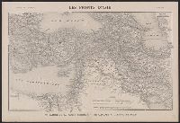
Creator:
Published / Created:
1916
Call Number:
53 1916A
Container / Volume:
BRBL_00285
Image Count:
1
Resource Type:
Maps, Atlases & Globes
Description:
"Supplément à l'Illustration.", In upper right corner: 22 Avril 1916., and Relief shown by hachures.
Publisher:
s.n.],
Subject (Geographic):
Iran--Maps, Middle East--Maps, and Turkey--Maps
Subject (Topic):
World War , 1914 -1918 --Turkey--Maps
Found in:
Beinecke Rare Book and Manuscript Library > Les fronts d'Asie : de Salonique au Golfe Persique du Caucase a l'Isthme de Suez / G. Peltier, delt.
Branch:v1.61.6 ,Deployed:2024-06-12T09:55:37-04:00