Search
You Searched For
Search Results
- Creator:
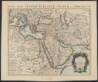
- L'Isle, Guillaume de, 1675-1726
- Published / Created:
- [after 1757]
- Call Number:
- 501 1720
- Container / Volume:
- BRBL_00275
- Image Count:
- 1
- Resource Type:
- Maps, Atlases & Globes
- Subject (Geographic):
- Africa, Northeast--Maps--Early works to
- Found in:
- Beinecke Rare Book and Manuscript Library > Carte de la Turquie de l'Arabie et de la Perse [cartographic material] : dressée sue les memoires les plus recens rectifiez par les observations de Mrs de l'Académie Royle. des Sciences / par G. de L'Isle, Geographe.
- Published / Created:
- [1751]
- Call Number:
- BrSides 2019 106
- Image Count:
- 1
- Resource Type:
- Maps, Atlases & Globes
- Subject (Geographic):
- Africa, Eastern--Maps--Early works to
- Found in:
- Beinecke Rare Book and Manuscript Library > Riget Monomotapa og de hosligende Stater af de l'Isle og andre Jordbeskrivere.
- Creator:
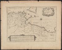
- Delarochette, L. (Louis), 1731-1802, creator
- Published / Created:
- 1780 June 28
- Call Number:
- 1982 Folio 10
- Image Count:
- 1
- Subject (Topic):
- Coasts --Africa, North --Maps --Early
- Found in:
- Beinecke Rare Book and Manuscript Library > A chart of the coasts of Spain and Portugal, with the Balearic Islands, and part of the coast of Barbary
- Call Number:
- 1974 Folio 72
- Collection Title:
- The English pilot: describing the West-India navigation, from Hudson's-Bay to the river Amazones
- Image Count:
- 1
- Subject (Geographic):
- Africa --Maps --Early works to 1800
- Found in:
- Beinecke Rare Book and Manuscript Library > A new and correct chart of the western and southern oceans
- Call Number:
- 1973 Folio 116
- Collection Title:
- The English pilot: describing the West-India navigation, from Hudson's-Bay to the river Amazones
- Image Count:
- 2
- Subject (Geographic):
- Africa --Maps --Early works to 1800
- Found in:
- Beinecke Rare Book and Manuscript Library > A new and correct chart of the western and southern oceans
- Call Number:
- 1973 Folio 114
- Collection Title:
- The English pilot: describing the West-India navigation, from Hudson's-Bay to the river Amazones
- Image Count:
- 1
- Resource Type:
- Maps, Atlases & Globes
- Subject (Geographic):
- Africa --Maps --Early works to 1800
- Found in:
- Beinecke Rare Book and Manuscript Library > A new and correct chart of the western and southern oceans ...
- Creator:
- Harris, I., d. 1739
- Call Number:
- 1978 Folio 10
- Collection Title:
- The English pilot: describing the West-India navigation, from Hudson's-Bay to the river Amazones
- Image Count:
- 1
- Subject (Geographic):
- Africa --Maps --Early works to 1800
- Found in:
- Beinecke Rare Book and Manuscript Library > A new and correct chart shewing the variations of the compass in the western & southern oceans
- Creator:
- Jansson, Jan, 1588-1664, cartographer
- Published / Created:
- 1652?]
- Call Number:
- 60 1652
- Container / Volume:
- BRBL_00321
- Image Count:
- 1
- Resource Type:
- Maps, Atlases & Globes
- Subject (Geographic):
- Africa, North--Maps--Early works to
- Found in:
- Beinecke Rare Book and Manuscript Library > Africae propriae tabvla [cartographic material] : in qua Punica regna vides, Tyrios et Agenoris urbem.
- Creator:
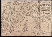
- Linschoten, Jan Huygen van, 1563-1611
- Published / Created:
- [1596?]
- Call Number:
- BrSides Folio 2019 95
- Image Count:
- 1
- Resource Type:
- Maps, Atlases & Globes
- Subject (Geographic):
- Africa, Eastern--Maps--Early works to
- Found in:
- Beinecke Rare Book and Manuscript Library > Deliniantur in hac tabula, Orae maritimae Abexiae, freti Mecani ; al. Maris Rubri ; Arabiae, Ormi, Persiae, suprà Sindam usque Fluminis Indi, Cambaiae Indiae & Malabaris, Insulae Ceylon, Choromandeliae, & Orixae, fluvii Gangis, & Regni Bengalae, situs item Sinuum, Insularum ... = Afbeeldinge der custen van Abex, der engte van Mecha, anders ghenaempt de Roode Zee, Item de custen van Arabien, Ormus, Persen tot Sinde toe / [Jan Huygen van Linschoten, Henricus F. ab Langren].
- Creator:
- Kitchin, Thomas, d. 1784, creator
Sayer, Robert, 1725-1794
- Published / Created:
- 1787 January 1
- Call Number:
- 1982 Folio 10
- Image Count:
- 2
- Subject (Geographic):
- Africa, North --Maps --Early works to
- Found in:
- Beinecke Rare Book and Manuscript Library > Europe divided into its empires, kingdoms, states, republics, & ca