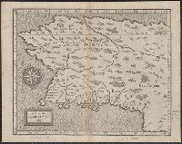
Appears in Salmon's The universal traveler., In lower left margin: Plate 226 no. 121 vol. 2 p. 669., Prime meridian: London., Relief shown pictorially., and Yale's copy stamped on verso: Yale, Horace Brown, 1900S.
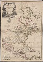
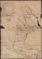
"Iohn Senex, sculpt.", Decorative title cartouche in upper left corner, with coat of arms below it. Four scales in lower left corner., Dedication: To the Honorable Anthony Hammond Esq. One of the Commissioners of Her Majties. Navy this Map is humbly dedicated and presented by his obliged servant., Hand col. Mounted on linen. Neat line measures 96 x 65.6 cm. on sheet 98.9 x 67.1cm. Cross Collection no. 148., Relief shown pictorially., Shows boundaries, rivers, forests and principal settlements, with notes., and Text passages include: "The Long River, or Dead River was discovered lately by the Baron Lahontan" ..." and "A lake of salt water ..."
Publisher:
John Senex?,
Subject (Geographic):
NorthAmerica--Maps--Early works to
Subject (Name):
Hammond, Anthony, 1668-1738, Lahontan, Louis Armand de Lom d'Arce, baron de, 1666-1715?, and Maxwell, John, fl. 1708-1711
"Iohn Senex, sculpt.", Decorative title cartouche in upper left corner, with coat of arms below it. Four scales in lower left corner., and Dedication: To the Honorable Anthony Hammond Esq. One of the Commissioners of Her Majties. Navy this Map is humbly dedicat
Publisher:
John Senex?,
Subject (Geographic):
NorthAmerica--Maps--Early works to
Subject (Name):
Hammond, Anthony, 1668-1738, Lahontan, Louis Armand de Lom d'Arce, baron de, 1666-1715?, and Maxwell, John, fl. 1708-1711
"Iohn Senex, sculpt.", Decorative title cartouche in upper left corner, with coat of arms below it. Four scales in lower left corner., Dedication: To the Honorable Anthony Hammond Esq. One of the Commissioners of Her Majties. Navy this Map is humbly dedicated and presented by his obliged servant., Label on verso with ms. no.: 523/4. Hand col. Sheet measures 97.7 x 68.6 cm. Cross Collection no. 147., Relief shown pictorially., Shows boundaries, rivers, forests and principal settlements, with notes., and Text passages include: "The Long River, or Dead River was discovered lately by the Baron Lahontan" ..." and "A lake of salt water ..."
Publisher:
John Senex?,
Subject (Geographic):
NorthAmerica--Maps--Early works to
Subject (Name):
Hammond, Anthony, 1668-1738, Lahontan, Louis Armand de Lom d'Arce, baron de, 1666-1715?, Maxwell, John, fl. 1708-1711, and Price, Charles, fl. 1700-1707
"Iohn Senex, sculpt.", Decorative title cartouche in upper left corner, with coat of arms below it. Four scales in lower left corner., Dedication: To the Honorable Anthony Hammond Esq. One of the Commissioners of Her Majties. Navy this Map is humbly dedicated and presented by his obliged servant., Label on verso with ms. no.: 71/7. Hand col. Mounted on linen. Sheet measures 96.8 x 67.1 cm. Cross Collection no. 146., Relief shown pictorially., Shows boundaries, rivers, forests and principal settlements, with notes., and Text passages include: "The Long River, or Dead River was discovered lately by the Baron Lahontan" ..." and "A lake of salt water ..."
Publisher:
John Senex?,
Subject (Geographic):
NorthAmerica--Maps--Early works to
Subject (Name):
Hammond, Anthony, 1668-1738 and Lahontan, Louis Armand de Lom d'Arce, baron de, 1666-1715?
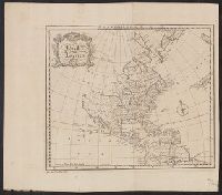
Dates inferred from similarity to variants dated c.1750 and c.1760 in Tooley's Mapping of America, p. 47 and 91., Includes text and ill., Relief shown pictorially., and Yale's copy 1 stamped on verso, "Yale, Horace Brown, 1900S." Copy 2 torn in 2 sheets, 47 x 68
Publisher:
John Bowles and Son in Cornhil :, printed for T. Bowles in St. Pauls Church yard :, and Robt. Sayer in Fleet Street,
Subject (Geographic):
NorthAmerica--Maps--Early works to
Subject (Name):
Bowles, John, 1701-1779, Bowles, Thomas, -1767, and Sayer, Robert, 1725-1794