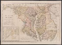
"W. Sander sculp.", "Zu Ebelings Erdbeschreibung von Amerika.", In upper right margin: No. X., Includes inset of western section of what is now Garrett and Allegany Counties., No watermark. Sheet measures 50.8 x 68.8 cm. Franklin Collection no. 131 1797-3., Place names in English and German., Prime meridians: Greenwich and Washington., Relief shown by hachures., and Watermark.
Publisher:
Bey CarlErnstBohn,
Subject (Geographic):
Delaware--Administrative and political divisions--Maps--Early works to 1800, Delaware--Maps--Early works to 1800, Maryland--Administrative and political divisions--Maps--Early works to 1800, and Maryland--Maps--Early works to
"Zu Ebelings Erdbeschreibung von Amerika.", Also shows county boundaries., Atlas plate: No. III., Place names in German and English., Prime meridians: Greenwich and Washington., Relief shown by hachures. Depths shown by soundings., and Sheet measures 51 x 70 cm. Franklin Collection no. 131 1796 3.
Publisher:
Bey CarlErnstBohn,
Subject (Geographic):
Massachusetts--Administrative and political divisions--Maps--Early works to 1800 and Massachusetts--Maps--Early works to 1800
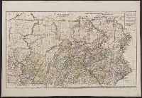
"W. Sander sc.", "Zu Ebelings Erdbeschreibung von Amerika.", Also shows county boundaries., Bar scales given in "Geographische Meilen 15 auf einen Grad" and "Englische meilen 69 4/25 auf einen Grad.", In upper right margin: No. IX., Place names in German and English., Prime meridians: Greenwich and Washington., Relief shown by hachures., Sheet measures 51 x 73.3 cm. Franklin Collection no. 131 1797 1., and Watermark.
Publisher:
Bey CarlErnstBohn,
Subject (Geographic):
Pennsylvania--Administrative and political divisions--Maps--Early works to 1800 and Pennsylvania--Maps--Early works to 1800
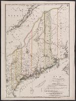
"Zu Ebelings Erdbeschreibung von America.", Also shows county boundaries., Bar scales given in "Geographische Meilen 15 auf einen Grad" and "Englische meilen 69 4/25 auf einen Grad.", Includes index to land grants., Place names in German and Englis, and Watermark.
Publisher:
Bey CarlErnstBohn,
Subject (Geographic):
Maine--Administrative and political divisions--Maps--Early works to 1800 and Maine--Maps--Early works to 1800
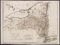
"W. Sander, sculp.", "Zu Ebelings Erdbeschreibung von Amerika.", Bar scales given in "Geographische Meilen oder ein Grad des Aequators" and "Englische meilen 69 4/25 auf einen Grad.", In upper right margin: No. VII., Place names in English and German., Prime meridians: Greenwich and Washington., Relief shown by hachures., Sheet measures 51.5 x 68.9 cm., Shows county and some township boundaries., and Watermark.
Publisher:
Bey CarlErnstBohn,
Subject (Geographic):
New York (State)--Administrative and political divisions--Maps--Early works to 1800 and New York (State)--Maps--Early works to 1800
Bohn, CarlErnst Ebeling, Christophe Daniel, 1741-1817. Erdbeschreibung und Geschichte von Amerika Sotzmann, D. F
Published / Created:
1797
Call Number:
1977 Folio 177
Image Count:
2
Resource Type:
Maps, Atlases & Globes
Description:
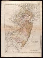
"Zu Ebelings Erdbeschreibung von Amerika.", Bar scales given in "Geographische Meilen 15. auf einen Grad" and "Englische meilen 69 4/25 auf einen Grad.", In upper right margin: No. VIII., Place names in English and German., Prime meridians: Greenwich and Washington., Relief shown by hachures., Sheet measures 74.5 x 53.8 cm. No. 4 of 34 maps bound together., and Watermark.
Publisher:
Bey CarlErnstBohn,
Subject (Geographic):
New Jersey--Administrative and political divisions--Maps--Early works to 1800 and New Jersey--Maps--Early works to 1800
Bohn, CarlErnst Ebeling, Christophe Daniel, 1741-1817. Erdbeschreibung und Geschichte von Amerika Schmidt, Paulus, engraver Sotzmann, D. F
Published / Created:
1796
Call Number:
1977 Folio 177
Image Count:
2
Resource Type:
Maps, Atlases & Globes
Description:
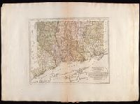
"Zu Ebelings Erdbeschreibung von Amerika.", Also shows county boundaries., Bar scales given in "Geographische Meilen 15 auf einen Grad" and "Englische meilen 69 4/25 auf einen Grad.", In upper right margin: No. VI., Place names in German and English., Prime meridians: Greenwich and Washington., Relief shown by hachures., Sheet measures 53.7 x 72.5 cm. No. 6 of 34 maps bound together., and Watermark.
Publisher:
Bey CarlErnstBohn,
Subject (Geographic):
Connecticut--Administrative and political divisions--Maps--Early works to 1800 and Connecticut--Maps--Early works to 1800
Bohn, CarlErnst Ebeling, Christophe Daniel, 1741-1817. Erdbeschreibung und Geschichte von Amerika Schmidt, Paulus, engraver Sotzmann, D. F
Published / Created:
1796
Call Number:
1977 Folio 177
Image Count:
2
Resource Type:
Maps, Atlases & Globes
Description:
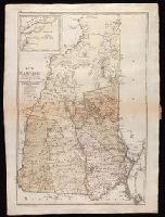
"Zu Ebelings Erdbeschreibung von Amerika.", Also shows county boundaries., In upper left margin: No. II., Inset: Nördlicher Theil der Grafschaft Grafton., Place names in German and English., Prime meridians: Greenwich and Washington., Relief shown by hachures., Sheet measures 73.1 x 53.1 cm. No. 8 of 34 maps bound together., and Watermark.
Publisher:
Bey CarlErnstBohn,
Subject (Geographic):
New Hampshire--Administrative and political divisions--Maps--Early works to 1800 and New Hampshire--Maps--Early works to 1800
Bohn, CarlErnst Ebeling, Christophe Daniel, 1741-1817. Erdbeschreibung und Geschichte von Amerika Kliewer, Heinrich, engraver Sotzmann, D. F
Published / Created:
1797
Call Number:
1977 Folio 177
Image Count:
2
Resource Type:
Maps, Atlases & Globes
Description:
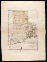
"Zu Ebelings Erdbeschreibung von Amerika.", Bar scales given in "Geographische Meilen 15 auf einen Grad" and "Englische meilen 69 4/25 auf einen Grad.", In upper right margin: No. V., Prime meridians: Greenwich and Washington., Relief shown by hachures. Depths shown by soundings., Sheet measures 72.3 x 53.5 cm. No. 7 of 34 maps bound together., and Watermark.
Publisher:
Bey CarlErnstBohn,
Subject (Geographic):
Rhode Island--Administrative and political divisions--Maps--Early works to 1800 and Rhode Island--Maps--Early works to 1800
Bohn, CarlErnst, publisher Ebeling, Christophe Daniel, 1741-1817. Erdbeschreibung und Geschichte von Amerika Schmidt, Paulus, engraver Sotzmann, D. F
Published / Created:
1796
Call Number:
1977 Folio 177
Image Count:
2
Resource Type:
Maps, Atlases & Globes
Description:
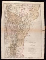
"Zu Ebelings Erdbeschreibung von Amerika.", Also shows county boundaries., Bar scales given in "Geographische Meilen 15 auf einen Grad" and "Englische meilen 69 4/25 auf einen Grad.", In upper right margin: No. XVI., Place names in German and English., Prime meridians: Greenwich and Washington., Relief shown by hachures., Sheet measures 72.8 x 54.3 cm. No. 10 of 34 maps bound together., and Watermark.
Publisher:
Bey CarlErnstBohn,
Subject (Geographic):
Vermont--Administrative and political divisions--Maps--Early works to 1800 and Vermont--Maps--Early works to 1800