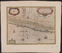
Bar scales i, Cross Collection no. 348., From Jan Jansson and Henrik Hondius's Atlas novus ... Amstelodami : Apud Ionnem Ianssonium & Henricum Hondium, 1638., Hand col., Oriented with north to the left., and Relief shown pictorially.
Publisher:
Henricus Hondius excudit,
Subject (Geographic):
Chile--Maps--Early works to 1800
Subject (Name):
Hondius, Hendrik, 1597-1651. Atlas novus and Jansson, Jan, 1588-1664. Atlas novus
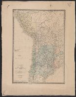
Bar scales in "Milliaria Gallica communia," "Leucae Hispanicae," and "Mil, From Jan Jansson's Nieuwen atlas ... Amsterdami : Apud Iohannem Ianssonium, 1647., Hand col. Sheet measures 50.1 x 60.3 cm., Oriented with north to the left., and Relief shown pictorially.
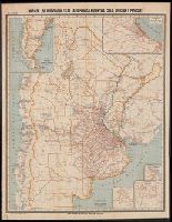
Accompanied by two notice slips. Sheets 1-2, 7, 10-13, 15-25, 30-33 are duplicates; sheet 7 has three copies [numbers have been given locally]., Includes 38 triangulation maps with title "Gráfico de los Trabajos Jeodésicos.", Maps dated 1906-1912; several maps undated., Sheets arranged in order by degree of latitude at its northern edge., and Title from index sheet.
Eigentliche vnd warhafftige Beschreibung / der wunderbaerlichen Schiffarth (der Hollaender
Image Count:
1
Description:
Left edge of map is folded inwards., Printed above map in center of page: Fol. 21., Scale [ca. 1:20,000,000]., and Upper left corner of map is mutilated with slight loss of ornament.
Subject (Geographic):
Chile --Maps
Collection Created:
Gedruckt zu Amsterdam / Durch Cornelium Nicolaum / Anno 1602
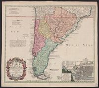
A note on the margin of the map in Latin text gives some historical data and comments upon the climate as being very cold and that the name (Chili) is therefore significan, In Latin and French., Inset: Plan de la ville de Santiago., and Relief shown pictorially.
Publisher:
Editoribus Homannianis Heredibus,
Subject (Geographic):
Santiago (Chile)--Maps--Early works to
Subject (Name):
Homann Erben (Firm). Atlas geographicus maior and Techo, Nicolás del, 1611-1685