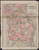
Skip to search
Skip to main content
Skip to first result
Search
You Searched For
"Georgia--Maps."
New Search
Search Results
Creator:
Published / Created:
1882
Call Number:
787 1882
Container / Volume:
BRBL_00517
Image Count:
1
Resource Type:
Maps, Atlases & Globes
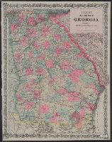
Description:
"Entered according to Act of Congress in ... 1866 by G.W. & C.B. Colton & Co. in New York." and Relief shown by hachures.
Publisher:
G.W. & C.B. Colton,
Subject (Geographic):
Georgia --Maps
Found in:
Beinecke Rare Book and Manuscript Library > Colton's map of the state of Georgia.
Published / Created:
1877
Call Number:
787hc 1864A
Container / Volume:
BRBL_00517A
Image Count:
1
Resource Type:
Maps, Atlases & Globes
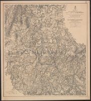
Description:
Map II. This map includes the region from Resaca on the north to Ackworth [sic] on the south and exhibits the works of the United States and Confederate forces (1864).
Publisher:
American Photo-Lithographic Co. ,
Subject (Geographic):
Georgia --Maps
Found in:
Beinecke Rare Book and Manuscript Library > Map illustrating the military operations of the Atlanta campaign. Map II. / compiled by authority of the Hon. the Secretary of War in the Office of the Chief of Engineers, U.S.A.
Published / Created:
1876
Call Number:
787hc 1864A
Container / Volume:
BRBL_00517A
Image Count:
1
Resource Type:
Maps, Atlases & Globes
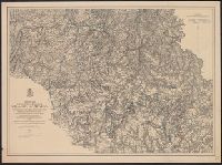
Description:
Map III. This map includes the region extending from Rome, Kingston, and Cassville on the north to include Dallas and Marietta on the south and exhibits the works of the United States and Confederate forces (1864)
Publisher:
American Photo-Lithographic Co. ,
Subject (Geographic):
Georgia --Maps
Found in:
Beinecke Rare Book and Manuscript Library > Map illustrating the military operations of the Atlanta campaign. Map III. / compiled by authority of the Hon. the Secretary of War in the Office of the Chief of Engineers, U.S.A.
Published / Created:
1874
Call Number:
787hc 1864A
Container / Volume:
BRBL_00517A
Image Count:
1
Resource Type:
Maps, Atlases & Globes
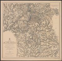
Description:
Map IV. Embracing the region from Pine, Lost, and Kennesaw Mountains south to include Atlanta and its environs, exhibiting the lines of operations at Pine, Lost, and Kennesaw Mts., at Smyrna Camp Ground a and Ms. notations in blue and red pencil.
Publisher:
American Photo-Lithographic Co. ,
Subject (Geographic):
Georgia --Maps
Found in:
Beinecke Rare Book and Manuscript Library > Map illustrating the military operations of the Atlanta campaign. Map IV. / compiled by authority of the Hon. the Secretary of War in the Office of the Chief of Engineers, U.S.A.
Published / Created:
1877
Call Number:
787hc 1864A
Container / Volume:
BRBL_00517A
Image Count:
1
Resource Type:
Maps, Atlases & Globes
Description:
Map V. This map includes the region from the Chattahoochee River south to Jonesboro and Lovejoy's Station and exhibits the works of the United States and Confederate forces (1877). and MS. notations in blue and red pencil.
Publisher:
American Photo-Lithographic Co. ,
Subject (Geographic):
Georgia --Maps
Found in:
Beinecke Rare Book and Manuscript Library > Map illustrating the military operations of the Atlanta campaign. Map V. / compiled by authority of the Hon. the Secretary of War in the Office of the Chief of Engineers, U.S.A.
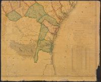
Call Number:
787 1818
Container / Volume:
BRBL_00516
Image Count:
4
Resource Type:
Maps, Atlases & Globes
Description:
4 sheets.
Publisher:
Eleazer Early. John Melish and Samuel Harrison.
Subject (Geographic):
Georgia --Maps
Found in:
Beinecke Rare Book and Manuscript Library > Map of the State of Georgia prepared from actual surveys and other documents for Eleazer Early [by] Daniel Sturges.
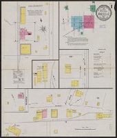
Published / Created:
1909
Call Number:
787 M768 1909
Container / Volume:
BRBL_00517
Image Count:
3
Resource Type:
Maps, Atlases & Globes
Description:
Sheet 1 includes index map and "Index" to streets and buildings by sheet number.
Publisher:
Sanborn Map Company,
Subject (Geographic):
Georgia --Maps
Found in:
Beinecke Rare Book and Manuscript Library > Monticello, Jasper County, Georgia.
Published / Created:
1881
Call Number:
787 1881
Container / Volume:
BRBL_00517
Image Count:
1
Resource Type:
Maps, Atlases & Globes
Publisher:
Henry S. Stebbens
Subject (Geographic):
Georgia --Maps
Found in:
Beinecke Rare Book and Manuscript Library > New Map of Georgia: showing railroads, Congressional districts and counties / Prepared expressly for the State Railroad Commission.
Published / Created:
1864
Call Number:
787hc C633 1864A
Container / Volume:
BRBL_00517A
Image Count:
1
Resource Type:
Maps, Atlases & Globes
Publisher:
Topl. Engr. Office ,
Subject (Geographic):
Georgia --Maps
Found in:
Beinecke Rare Book and Manuscript Library > Part of Cobb and Fulton counties, Georgia. / Compiled from land maps and information at Topl. Engr. Office Army of the Cumberland Marietta Ga. July 7th, 1864.
Published / Created:
c1903.
Call Number:
787 1903
Container / Volume:
BRBL_00517
Image Count:
2
Resource Type:
Maps, Atlases & Globes
Description:
Index to counties, creeks, islands, rivers and towns on verso., Legend: Railroad mileage in the state of Georgia., and Relief shown by hachures.
Publisher:
Rand McNally & Co.,
Subject (Geographic):
Georgia --Maps
Found in:
Beinecke Rare Book and Manuscript Library > Railroad map of Georgia.
Branch:v1.61.8 ,Deployed:2024-06-20T11:14:48-04:00