Skip to search
Skip to main content
Skip to first result
Search
You Searched For
%22North America--Maps%22
New Search
Search Results
Creator:
Published / Created:
MDCXIII [1613]. Avec privilege dv Roy.
Call Number:
Taylor 257
Image Count:
1
Resource Type:
Books, Journals & Pamphlets
Alternative Title:
Carte geographique de la nouelle Franse en son vray mondia., Carte geographique de la novvelle Franse., and Voyages du sieur de Champlain Xaintongeois, capitaine ordinaire pour le Roy, en la marine.
Description:
22 x 26 cm.) bound in after p. 22 (first
Publisher:
Chez Iean Berjon, rue S. Iean de Beauuais, au Cheual volant, & en sa boutique au Palais, à la gallerie des prisonniers,
Subject (Geographic):
New France--Maps .
Subject (Name):
Pelletier, David.
Subject (Topic):
Indians of North America --Canada.
Found in:
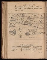
Beinecke Rare Book and Manuscript Library > Les voyages dv sievr de Champlain Xaintongeois, capitaine ordinaire pour le Roy, en la marine : divisez en devx livres, ou, iovrnal tres-fidele des observations faites es descouuertures de la Nouuelle France : tant en la descriptiõ des terres, costes, riuieres, ports, haures, leurs hauteurs, & plusieurs declinaisons de la guide-aymant : qu'en la crẽace des peuples, leur superstition, façon de viure & de guerroyer : enrichi de quantité de figures : Ensemble deux cartes geografiques : la premiere seruant à la nauigation, dressée selon les compas qui nordestent, sur lesquels les mariniers nauigent : l'autre en son vray Meridien, auec ses longitudes & latitudes : à laquelle est adiousté le voyage du destroict qu'ont trouué les Anglois, au dessus de Labrador, depuis le 53e. degré de latitude, iusques au 63e. en l'an 1612, cerchans vn chemin par le Nord, pour aller à la Chine.
Creator:
Published / Created:
[1794?]
Call Number:
EEa 794b
Image Count:
1128
Resource Type:
Books, Journals & Pamphlets
Description:
Irregularities in paging 1 map (Europe
Publisher:
Sold by A. Hogg
Subject (Name):
Haswell, N.B.--Autograph., Hogg, Henry., Outlon, Clement Walley., and Robertson, Charles Andrew.
Subject (Topic):
Geography.
Found in:
Beinecke Rare Book and Manuscript Library > A new, royal, authentic, complete, and universal system of geography: or, A modern history and description of the whole world. Containing ... accounts and descriptions of Europe, Asia, Africa, and America ... including the substance and essence of the most remarkable voyages and travels ... particularly the late discoveries in the South seas, and towards the North pole ... Comprising every interesting discovery and circumstance in the narratives of Captain Cook's voyages round the world. Together with all the recent discoveries ... carefully written and compiled from the late journals of ... Captains Phillips, King, Ball, Hunter, White, Dixon, Portlock, Mears, Patterson, Bruce, Anbury, Rochon, Morse, Blyth, Ross, Imlay, Keate, Brissot, Hodges, &c. &c. Also compendious histories of every empire, kingdom, state, &c. ... The whole embellished and enriched with upwards of an hundred most elegant and superb copperplates ... By George Augustus Baldwyn, esq. assisted by many gentlemen eminent for their knowledge ... of geography; particularly Charles Andres Robertson, esq.--Clement Walley Oulton. esq.-- and Henry Hogg ...
Creator:
Published / Created:
[1599]
Call Number:
Gfp94 gi561e
Image Count:
12
Resource Type:
Maps , Atlases & Globes
Alternative Title:
Geografia di Clavdio Tolomeo Alessandrino and Geographia. Italian. 1599
Description:
old in text double maps , on inner forms of
Publisher:
Appresso gli heredi di Melchior Sessa,
Subject (Geographic):
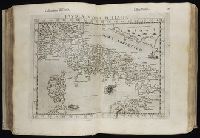
America --Geography--Maps
Subject (Name):
Rosaccio, Giuseppe, approximately 1530-approximately 1620, Ruscelli, Girolamo, -approximately 1565, and Thorne Collection of Cartogaphy and Geography Bookplate.
Subject (Topic):
Geography, Ancient--Maps
Found in:
Beinecke Rare Book and Manuscript Library > Geografia di Claudio Tolomeo Alessandrino [cartographic material] / tradotta di Greco nell'idioma volgare Italiano da Girolamo Ruscelli, et hora nuouamente ampliata da Gioseffo Rosaccio, con varie annotationi, & espositioni, & tauole di rame, che nelli stampati altre volte non erano, hauendo etiando poste à i lor luoghi le tauole vecchie, che prima confusamente giaceuano, et vna Geografia vniuersale del medesimo, separata da quella di Tolomeo; nella quale secondo il parere de' più moderni geografi, fedelmente sono poste le prouincie, regni, città, castelli, monti, fiumi, laghi, porti, golfi, isole, penisole, popoli, leggi, riti, & costumi di ciascuna città. Et vna breue descrittione di tutta la terra, distinta in quattro libri, nel primo de' quali si tratta dell'Europa; nel secondo dell'Africa; nel terza dell'Asia, nel quarto dell'America. Con due indici copiosissimi di tutto quello, che di notabile si contiene nell'opera.
Creator:
Published / Created:
1590
Call Number:
Taylor 194
Image Count:
71
Publisher:
Typis I. Wecheli, svmtibvs vero T. de Bry
Subject (Geographic):
North Carolina -- Description and travel -- Early works to 1800, Roanoke Colony (N.C.), Virginia --Description and travel, and Virginia --History --Colonial period, ca. 1600-1775 --Sources
Subject (Name):
Grenville, Richard, 1542-1591 and Raleigh's Roanoke colonies, 1584-1590
Subject (Topic):
Indians of North America --Pictorial
Found in:
Beinecke Rare Book and Manuscript Library > A briefe and true report of the new found land of Virginia: of the commodities and of the nature and manners of the naturall inhabitants. Discouered by the English colony there seated by Sir Richard Greinuile ... in ... 1585 ... This fore booke is made in
Branch:v1.61.8 ,Deployed:2024-06-20T11:14:55-04:00