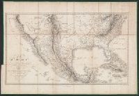
Includes text and list of town popula, Prime meridians: Greenwich and Washington., Relief shown by hachures., and Shows Indian tribes and various routes, including "Pike's Route," "Long's Route," "Gregg's Route in 1840," and "Road to Santa Fé laid out in 1825."
Publisher:
War Dept.,
Subject (Geographic):
Southwestern States--Maps and Texas--Maps
Subject (Name):
Abert, John James, 1788-1863, United States. Army. Corps of Topographical Engineers, and United States. War Dept
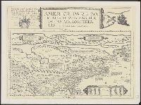
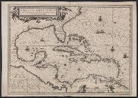
Chart of the West-Indies or the islands of America in the North Sea
Description:
"P. 734, v. 11.", Covers North and South American coastline from Albemarle Sound to the mouth of the Orinoco R., and Includes text and inset of "La Veracruz."
Publisher:
s.n., 1745?]
Subject (Geographic):
Caribbean Area--Maps--Early works to 1800 and West Indies--Maps--Early works to 1800
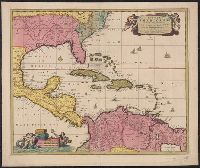
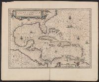
"Cum Privilegio Ordinum Hollandiae et Westfrisiae.", Appears in Visscher's Atlas minor., Includes scales in milliaria germanica, hispanica, and gallica., Mounted on linen. Sheet measures 51.5 x 61.8 cm. Cross Collection no. 238., Relief shown pictorially., and Shows the West Indies and Central America from Florida to the northern part of South America, including boundaries, settlements and rivers.
Publisher:
Nunc apud Petrum Schenk Junior,
Subject (Geographic):
Caribbean Area--Maps--Early works to 1800, Mexico, Gulf of--Maps--Early works to 1800, and West Indies--Maps--Early works to 1800
Subject (Name):
Schenk, Pieter, ca. 1698-1775 and Visscher, Nicolaes, 1649-1702. Atlas minor
"Cum Privilegio Ordinum Hollandiae et Westfrisiae.", Appears in Visscher's Atlas minor., In, Relief shown pictorially., and Shows the West Indies and Central America from Florida to the northern part of South America, including boundaries, settlements and rivers.
Publisher:
Nicolaes Visscher,
Subject (Geographic):
Caribbean Area--Maps--Early works to 1800, Mexico, Gulf of--Maps--Early works to 1800, and West Indies--Maps--Early works to 1800
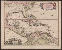
Insulae Americanae in Oceano Septentrionali cum terris adjacentibus and Insvlae Americanae in Oceano Septentrionali cum terris adiacentibus
Description:
Includes embellished title cartouche, dedication with coats-of-arms, scale and ill. of ships at sea., No text on verso., Sheet measures 40.1 x 56.8 cm. Ms. notes on verso. Stamp on verso: T.W. Streeter., and Shows southeast coast of North America from Virginia to north coast of South America to east of Trinidad, west coast of Central America, West Indies.
Publisher:
Apud Ioannem Ianssonium,
Subject (Geographic):
Caribbean Area--Maps--Early works to 1800, Mexico, Gulf of--Maps--Early works to 1800, and West Indies--Maps--Early works to 1800
Subject (Name):
Streeter, Thomas W.--(Thomas Winthrop),--1883-1965--Stamp
Insulae Americanae in Oceano Septentrionali cum terris adjacentibus and Insvlae Americanae in Oceano Septentrionali cum terris adiacentibus
Description:
Appears in various Dutch eds. of Jansson's Nieuwen atlas., Includes scales in milliaria germanica and mill, and Shows southeast coast of North America from Virginia to north coast of South America to east of Trinidad, west coast of Central America, West Indies.
Publisher:
Apud Ioannem Ianssonium,
Subject (Geographic):
Caribbean Area--Maps--Early works to 1800, Mexico, Gulf of--Maps--Early works to 1800, and West Indies--Maps--Early works to 1800
Insulae Americanae in Oceano Septentrionali cum terris adjacentibus and Insvlae Americanae in Oceano Septentrionali cum terris adiacentibus
Description:
Cf. Burden, P.D. Mapping of North America, 242., Cf. Koeman, C. Atlantes Neerlandici (1997 ed.), II, p. 600 (map 9600:2B)., Includes dedication to "D. Alberto Conradi Vander Burch" signed "tabulam hanc inscribit Guiljelmus Blaeu.", Includes embellished title cartouche, dedication with coats-of-arms, scale and ill. of ships at sea., and Includes scales in milliaria germanica and milliaria hispanica.
Publisher:
s.n.,
Subject (Geographic):
Caribbean Area--Maps--Early works to 1800, Mexico, Gulf of--Maps--Early works to 1800, and West Indies--Maps--Early works to 1800