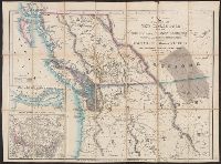
Atwood, John M., approximately 1818- cartographer.
Published / Created:
1849
Call Number:
71 1849
Image Count:
1
Resource Type:
Maps, Atlases & Globes
Description:
Includes 2 insets, ill., and distance table., Prime meridians: Greenwich and Washington., Relief shown by hachures and spot heights., Shows California's gold region and western trails., and Variant ed. in same year.
Publisher:
J.H. Colton,
Subject (Geographic):
NorthAmerica--Maps.
Subject (Name):
Colton, J. H. (Joseph Hutchins), 1800-1893, publisher.
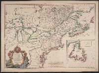
Cut and mounted on linen; "Wyld's new maps" advertisement on verso., Forts; boundaries; Indians; proposed railway; gold; coal., and Insets: Strait of San Juan de Fuca. -- on an enlarged scale. -- 7.4 x 8 cm.; British possessions in North America. -- scale [1:34
Publisher:
James Wyld,
Subject (Geographic):
British Columbia--Maps and Canada--Boundaries--United States--Maps
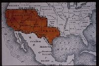
The description of this slide reflects the way that Erdoes organized 35mm slides. Erdoes arranged his slides in labeled containers that were sub-divided into labeled sections. The title for this image has been transcribed from its sub-section label; images of other slides from the same sub-section share the container title. The date listed here reflects a span of known dates associated the sub-section. In some cases, titles have been expanded to note particular individuals who appear frequently and who were identified by Erdoes in captions. Individual slide captions have not been transcribed or captured during digitization.
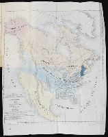
"Avec Privilege ... ", 1st state. Distinguishing feature of 1st state: "Area south of Lake Erie shows Ohio River running east to west, no forts" (Pedley 212)., Also shows Indian lands., Inset map: "Supplément pour l'isle de Terre-Neuve.", and Published separatel
Publisher:
Chés l'auteur, quai de l'horloge du palais proche le pont-neuf ... ,
Subject (Geographic):
Canada--Maps--Early works to 1800, Newfoundland and Labrador--Maps--Early works to 1800, and United States--History--French and Indian War, 1755-1763--Maps--Early works to 1800
Subject (Name):
Argenson, Marc-Pierre de Voyer, comte d', 1696-1764, dedicatee
Relief shown by hachures. and Shows "Kaw Trust Lands," "diminished reserve," deeded lands, and townships and sections in Morris, Wabaunsee, and Lyon counties.