Skip to search
Skip to main content
Skip to first result
Search
You Searched For
"Argentina--Maps"
New Search
Search Results
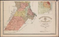
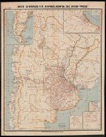
Published / Created:
1913
Call Number:
94 Sa59 1913
Container / Volume:
BRBL_00675
Image Count:
3
Resource Type:
Maps, Atlases & Globes
Description:
2 insets, var. scales.
Publisher:
s.n.,
Subject (Geographic):
Santa Fé (Argentina )--Maps
Found in:
Beinecke Rare Book and Manuscript Library > Provincia de Santa Fé : Registro Grafico.
Published / Created:
1888
Call Number:
94eh P27 1888
Container / Volume:
BRBL_00675
Image Count:
1
Resource Type:
Maps, Atlases & Globes
Description:
Also has a map of central and southern Patagonia and Tierra del Fuego.
Subject (Geographic):
Tierra del Fuego (Argentina )--Maps
Found in:
Beinecke Rare Book and Manuscript Library > Missioni Salesiane della Patagonia Settentrionale.
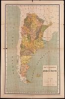
Published / Created:
1911
Call Number:
BrSides Double Folio 2019 94
Image Count:
2
Resource Type:
Maps, Atlases & Globes
Alternative Title:
Ricordo della repubblica Argentina all' Esposizione Internazionale delle Industrie e del Lavoro di Torino, 1911
Description:
Descriptive text on verso compiled by Alberto B. Martinez. and Relief shown by hachure.
Publisher:
Comite argentino,
Subject (Geographic):
Argentina --Maps
Subject (Name):
Martínez, Alberto B.
Found in:
Beinecke Rare Book and Manuscript Library > Carta geografica della repubblica Argentina.
Published / Created:
[1913?]
Call Number:
94 1913
Container / Volume:
BRBL_00721
Image Count:
1
Resource Type:
Maps, Atlases & Globes
Alternative Title:
[Northeastern tip of Argentina]
Description:
Boundaries and rivers marked in colored ink. and Ms. notes: "Diciembre de 1913".
Subject (Geographic):
Yerbales de San Antonio (Argentina
Found in:
Beinecke Rare Book and Manuscript Library > Yerbales de San Antonio : [Northeastern tip of Argentina].
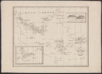
Published / Created:
[1830?]
Call Number:
966 1830
Container / Volume:
BRBL_00676
Image Count:
1
Resource Type:
Maps, Atlases & Globes
Description:
Inset: Dirk Gerrits Land
Subject (Geographic):
Argentina )--Maps
Found in:
Beinecke Rare Book and Manuscript Library > Kaart van Straat Magellaan, Straat le Maire, Het Vuurland en Kaap Hoorn.
Creator:
Published / Created:
[1850?]
Call Number:
90 1850
Container / Volume:
BRBL_00663
Image Count:
1
Resource Type:
Maps, Atlases & Globes
Description:
Outside neat line at lower right: No. 49.
Publisher:
Ch. Delagrave, editeur, 58 rue des Ecoles,
Subject (Geographic):
Argentina --Maps
Subject (Name):
Levasseur, Emile, 1828-1911
Found in:
Beinecke Rare Book and Manuscript Library > Carte générale du Pérou, de la Bolivie, du Chili et de la Plata : Dressée par A. Brué, géographe / Revue par E. Levasseur membre de l'institut.
Published / Created:
[1912?].
Call Number:
935gme 1912
Container / Volume:
BRBL_00674
Image Count:
1
Resource Type:
Maps, Atlases & Globes
Description:
"VIII. Edicion.", Inset: Mapa de la Parte Sud de la Republica Argentina., Insets: Buenos Aires, Mendoza, Rosario, and Tucuman., and Mounted on linen.
Publisher:
[Publicado por la] Oficina Cartográfica de Pablo Ludwig,
Subject (Geographic):
Argentina --Maps
Found in:
Beinecke Rare Book and Manuscript Library > Mapa de los ferrocarriles de la República Argentina, Chile, Uruguay y Paraguay.
Published / Created:
1904]
Call Number:
911fab 1904
Container / Volume:
BRBL_00671
Image Count:
1
Resource Type:
Maps, Atlases & Globes
Description:
"Nota-El original ha sido constrido en la de 1:500,000."
Publisher:
s.n.,
Subject (Geographic):
Brazil--Boundaries--Argentina --Maps
Found in:
Beinecke Rare Book and Manuscript Library > Plano de la frontera entre la Republica Argentina n los Estados Unidos del Brasil, 1900-04 [cartographic material].
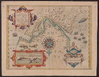
Published / Created:
1612
Call Number:
946 1612
Container / Volume:
BRBL_00675
Image Count:
2
Resource Type:
Maps, Atlases & Globes
Description:
By Gerard Mercator.
Subject (Geographic):
Tierra del Fuego (Argentina )--Maps
Found in:
Beinecke Rare Book and Manuscript Library > Exquisita & magno aliquot mensium periculo lustrata etiam retecta Freti Magellanici facies.
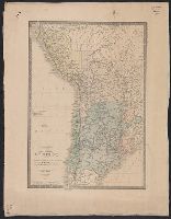
Published / Created:
1907
Call Number:
92b 1907
Container / Volume:
BRBL_00721
Image Count:
1
Resource Type:
Maps, Atlases & Globes
Description:
Bar scales given in "Leguas Argentinas" and "Kilometros.", Coordinates not present on map and are approximated., North oriented towards the right., and Two maps of same geographic area, one base-line with no annotations and one annotated with property owership.
Subject (Geographic):
Corrientes (Argentina : Province)--Maps .
Subject (Topic):
Real property--Argentina--Corrientes (Province)--Maps.
Found in:
Beinecke Rare Book and Manuscript Library > Map of the northern portion of Corrientes Province in Argentina.
Branch:v1.64.0 ,Deployed:2024-09-11T10:25:25-04:00