Skip to search
Skip to main content
Skip to first result
Search
You Searched For
"Georgia--Maps."
New Search
Search Results
Published / Created:
1899
Call Number:
787 1899
Container / Volume:
BRBL_00517
Image Count:
1
Resource Type:
Maps, Atlases & Globes
Description:
Shows RR.
Publisher:
Rand McNally & Co. ,
Subject (Geographic):
Georgia --Maps
Found in:
Beinecke Rare Book and Manuscript Library > Rand McNally & Co.'s Georgia
Published / Created:
1864
Call Number:
787hc 1864B
Container / Volume:
BRBL_00517A
Image Count:
1
Resource Type:
Maps, Atlases & Globes
Description:
Mounted on linen, annotated verso: "Maj. Genl. John A. Logan, Comdg. 15th A.C. From Engr. Office".
Publisher:
Engineer Bureau,
Subject (Geographic):
Georgia --Maps
Found in:
Beinecke Rare Book and Manuscript Library > [Part of eastern Georgia].
Published / Created:
1864
Call Number:
787hc 1864B
Container / Volume:
BRBL_00517A
Image Count:
1
Resource Type:
Maps, Atlases & Globes
Description:
Annotated: "From Chief. Engr.'s Office, Mily. Divn. O.M. Poe, Bvt. Col. & Chf. Engr".
Publisher:
Engineer Bureau,
Subject (Geographic):
Georgia --Maps
Found in:
Beinecke Rare Book and Manuscript Library > [Part of eastern Georgia].
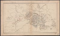
Creator:
Published / Created:
1891]
Call Number:
787hc At62 1864
Container / Volume:
BRBL_00517A
Image Count:
1
Resource Type:
Maps, Atlases & Globes
Alternative Title:
Operations of the Army under the com'd of Maj. Gen. W.T. Sherman in Georgia. and Siege of Atlanta.
Description:
Also on sheet: Brooks, A.F. Map illustrating the operations of the Army under the com'd of Maj. Gen. W.T. Sherman in Georgia, from May 5th, 1864 to Sep and Plate 88 from: "Atlas to accompany the official records of the Union and Confederate armies 1861-1865."
Publisher:
U.S. War Dept.,
Subject (Geographic):
Atlanta (Georgia )--Maps
Subject (Name):
Brooks, A. F. Map illustrating the operations of the Army under the com'd of Maj. Gen. W. T. Sherman in Georgia, from May 5th, 1864 to Sept. 4th, 1864, Poe, O. M. (Orlando Metcalfe), 1832-1895, and United States. War Dept. Atlas to accom
Subject (Topic):
Atlanta Campaign, 1864--Maps
Found in:
Beinecke Rare Book and Manuscript Library > Map illustrating the siege of Atlanta, Ga. : by the United States forces under command of Maj. Gen. W.T. Sherman from the passage of Peachtree Creek, July 19th 1864 to the commencement of the movement upon the enemy's lines of communication south of Atlan
Published / Created:
1864
Call Number:
787hc R311 1864
Container / Volume:
BRBL_00715
Image Count:
1
Resource Type:
Maps, Atlases & Globes
Description:
Color: some blue, red. and Ketch'd and drawn by Schultze, Private.
Subject (Geographic):
Georgia --Maps , Manuscript
Found in:
Beinecke Rare Book and Manuscript Library > Sketch showing the March from Snake Creek Gap to, and the positions before Resaca, GA., of 1st division 15th Army Corps, Brig. Genl. P.J. Osterhaus Comdg. May 13th, 14th, and 15th, 1864.
Creator:
Published / Created:
1944
Call Number:
354ed 1944
Container / Volume:
BRBL_00113
Image Count:
1
Resource Type:
Maps, Atlases & Globes
Alternative Title:
Tiflis
Description:
In upper right corner of margin: Nur für den Dienstgebrauch., Index to adjoining sheets., and Key to symbology representing distribution of ethnic groups.
Publisher:
Publikationsstelle,
Subject (Geographic):
Tʻbilisi (Georgia )--Maps
Subject (Topic):
Ethnology--Georgia (Republic)--Tʻbilisi--Maps
Found in:
Beinecke Rare Book and Manuscript Library > Weltkarte 1:1,000.000. K 38. Tiflis / unter Leitung von W. Krallert bearbeitet.
Creator:
Published / Created:
1864]
Call Number:
787hc 1864C
Container / Volume:
BRBL_00517A
Image Count:
2
Resource Type:
Maps, Atlases & Globes
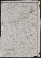
Alternative Title:
[Sherman map collection ; no. 22]
Description:
"Lithographed Topo'l Eng'r Office, Head-Quarters, Dep't of the Cumberland.", Covers a portion of northwestern Georgia and adjacent Alabama to the west of Atlanta., Endorsed (facsim.): Official issue. Wm. C. Margedant, Capt. & Supt., and Relief shown by hachures.
Publisher:
Corps of Topographical Engineers,
Subject (Geographic):
Georgia --Maps
Subject (Name):
Margedant, Wm. C. (William C.) and United States. Army. Corps of Topographical Engineers
Found in:
Beinecke Rare Book and Manuscript Library > Part of northern Georgia : / compiled under the direction of Capt. Wm. E. Merrill, Chief Top'l Eng'r, D.C.
Creator:
Published / Created:
[1861?]
Call Number:
754 1861C
Container / Volume:
BRBL_00416
Image Count:
1
Resource Type:
Maps, Atlases & Globes
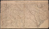
Description:
["Chas. G. Krebs, Lith."], ["Drawn by A. Lindenkohl."], and See Phillips, p. 299.
Publisher:
U.S. Coast Survey,
Subject (Geographic):
Georgia --Maps
Subject (Name):
Krebs, Charles G and Lindenkohl, A
Found in:
Beinecke Rare Book and Manuscript Library > Middle Georgia & South Carolina.
Creator:
Published / Created:
1865
Call Number:
754 1865A
Container / Volume:
BRBL_00417
Image Count:
1
Resource Type:
Maps, Atlases & Globes
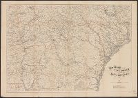
Description:
Relief shown by hachures.
Publisher:
U.S. Coast Survey,
Subject (Geographic):
Georgia --Maps
Subject (Name):
Bache, A. D. (Alexander Dallas), 1806-1867 and Lindenkohl, A
Found in:
Beinecke Rare Book and Manuscript Library > Southern Georgia and part of South Carolina / U.S. Coast Survey, A.D. Bache, supdt. ; drawn by A. Lindenkohl.
Creator:
Published / Created:
1865
Call Number:
754 1865C
Container / Volume:
BRBL_00417
Image Count:
1
Resource Type:
Maps, Atlases & Globes
Description:
State names, stae lines, railways and major rivers noted in red.
Publisher:
U.S. Coast Survey,
Subject (Geographic):
Georgia --Maps
Subject (Name):
Bache, A. D. (Alexander Dallas), 1806-1867, Krebs, Charles G.,, and Lindenkohl, A
Found in:
Beinecke Rare Book and Manuscript Library > Southern Georgia and part of South Carolina / U.S. Coast Survey, A.D. Bache, supdt. ; drawn by A. Lindenkohl; Chas. G. Krebs, lith.
Branch:v1.61.8 ,Deployed:2024-06-20T11:15:15-04:00