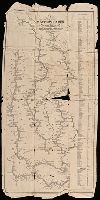
Color: pen with coasts outlined in grey watercolor, gold lettering., Invoice from H.P. Kraus Rare Books., and Lower Miss. Valley before New Orleans. 15 Indian Villages and French forts.
Course of the river Mississippi from the Balise to Fort Chartres
Description:
From Thomas Jeffery's The American atlas. 1775. Also published in Faden's North America Atlas, 1777., Imperfect: torn along fold. Title in manuscript on verso., Map of the Mississippi River Valley from the Gulf of Mexico to Fort Chartres, Illinois. Covers the Mississippi Valley from the Delta of the Mississippi where it joins the Gulf of Mexico to Fort Chartres., Prime meridian: New Orleans., Relief shown pictorially and by hachures. Depths shown by soundings., Scale of "Sea Leagues, 20 to a Degree"; and "British Miles, 69 1/2 to a Degree" below the imprint., Second issue. The first issue appeared in 1772. This 1775 issue has many changes in the area around New Orleans including the addition of forts St. Leon and St. Mary. Shows Baton Rouge and Lake Pontchartrain., The first official English survey of the Lower Mississippi, and one of the most historically significant American maps, delineating the British gains from France in the French and Indian War and later establishing the future western boundary of the new United States., The map includes detail of the lands to the immediate east of the Mississippi including numerous tributary rivers: the Pearl River, the Yasous River, the Chickasaw River, and the Ohio River. The locations of tribal lands and villages are noted, as well as alliances, roads to reach the villages, and the number of soldiers for several villages. Some tribes delineated in the map include the Arkansas, Chocktaw, Chicasaw, Yazoo, Wiapes, and Caskaskias., and Watermark.
Publisher:
Printed for Robt. Sayer, No. 53 in Fleet Street. Publishd as the Act directs,
Subject (Geographic):
MississippiRiver Valley--Maps--Early
Subject (Name):
Jefferys, Thomas, -1771. American atlas. and Sayer, Robert, 1725-1794
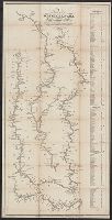
Mississippi and tributaries, their systems of drainage and downfall.
Description:
"Note. This map is mainly reduced from the official map, compiled in the Office of Explorations to exh and "Prepared to accompany the report of Capt. A.A. Humphreys and Lieut. H.L. Abbot, Corps of Top'l. Eng'rs. U.S.A. to the Bureau of Topl. Engrs., War Dept.
Publisher:
Corps of Top'l. Eng'rs., U.S.A.,
Subject (Geographic):
MississippiRiver Watershed--Maps
Subject (Name):
P.S. Duval & Son, Shoemaker, J. C, and United States. Army. Corps of Topographical Engineers
"Engraved according to act of Congress in the year 1842 by Saml. B. Munson ...", Imperfect: torn along folds, with some loss of text. Removed from the Roger Sherman papers., Includes distance table., and Orientation of rivers varies.
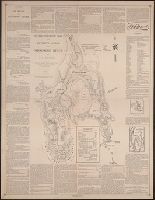
Nicollet's source of the Mississippi. and Sketch map of the Itasca Lake region.
Description:
Includes text., Insets: Nicollet's source of the Mississippi -- Sketch map of the Itasca Lake region., References given for altitudes, distances, source discoveries, and geographic positions., and Relief shown by hachures.
"Engraved by Thos. Twichell for Doolittle & Munson.", "Entered according to act of Congress in the year 1842 by Saml. B. Munson ...", and Includes distance list.
Publisher:
Doolittle & Munson,
Subject (Geographic):
MississippiRiver--Maps.
Subject (Name):
Doolittle & Munson, publisher. and Twichell, Thos. (Thomas), engraver.
Map: Carte de la Nouuelle France et de la Louisiane, nouuellement decouuerte, dediée au roy, l'an
Image Count:
1
Description:
From an original by Rouselle with inset designed by N. Guerard., Preceding p. 1., and Teaching resource: Professor John Mack Faragher, History 141: The American West.
Subject (Topic):
MississippiRiver Valley --Maps
Collection Created:
A Paris : Chez la veuve Sebastien Hure ... , MDCLXXXIII [1683]