Skip to search
Skip to main content
Skip to first result
Search
You Searched For
"British Columbia--Maps"
New Search
Search Results
Published / Created:
1909
Call Number:
739gme 1909
Container / Volume:
BRBL_00393
Image Count:
1
Resource Type:
Maps, Atlases & Globes
Description:
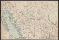
Atlas Map of British Columbia ."
Publisher:
Rand McNally & Co., Map Publishers and Engravers,
Subject (Geographic):
British Columbia --Maps
Found in:
Beinecke Rare Book and Manuscript Library > British Columbia [Railroads].
Published / Created:
1904
Call Number:
739 1904
Container / Volume:
BRBL_00388
Image Count:
1
Resource Type:
Maps, Atlases & Globes
Description:
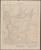
Cities; towns; railways; Indian reserves and villages; national parks; survey districts, sections and lots; forest reserves; electric railway.
Publisher:
Department of the Interior ;
Subject (Geographic):
British Columbia --Maps
Found in:
Beinecke Rare Book and Manuscript Library > British Columbia railway belt / [by] James White, F.R.G.S., Geographer: Department of the Interior; Honourable Clifford Sifton, Minister; James S. Smart, Deputy Minister.
Published / Created:
[c1925].
Call Number:
739 1925
Container / Volume:
BRBL_00389
Image Count:
1
Resource Type:
Maps, Atlases & Globes
Description:
"221"; "222", "Alexander Gross, F.R.G.S.", and Inset: Minerals.
Publisher:
"Geographia" Ltd.,
Subject (Geographic):
British Columbia --Maps
Found in:
Beinecke Rare Book and Manuscript Library > British Columbia.
Creator:
Published / Created:
1929
Call Number:
739G 1929C
Container / Volume:
BRBL_00392
Image Count:
2
Resource Type:
Maps, Atlases & Globes
Description:
"Map No. 1L.", Includes location map and notes on livestock, wildlife, agriculture and natural resources., and Relief shown by contours and spot heights.
Publisher:
Dept. of Lands,
Subject (Geographic):
British Columbia --Maps
Subject (Name):
Aitken, G. G
Found in:
Beinecke Rare Book and Manuscript Library > Central British Columbia.
Published / Created:
[1866]
Call Number:
739 1866
Container / Volume:
BRBL_00388
Image Count:
1
Resource Type:
Maps, Atlases & Globes
Description:
[In lower right corner: Robt. Homfray C.D. Victoria. Feby. 1866].
Publisher:
Published by order of the Victoria Chamber of Commerce. E. Fletcher, lith. ;
Subject (Geographic):
British Columbia --Maps
Found in:
Beinecke Rare Book and Manuscript Library > Guide Map to the Big Bend on the Columbia River and other Gold Mines in British Columbia : Distances according to official authorities ...
Published / Created:
1915
Call Number:
WA Photos 210
Collection Title:
Lantern slides of an expedition in British Columbia and Alberta, Canada
Container / Volume:
Box 1 | Folder 1
Image Count:
1
Abstract:
Lantern slides of photographs that chiefly document an expedition led by Samuel Prescott Fay in the northern Canadian Rockies from Jasper, Alberta, to Hudson's Hope, British Columbia, from June to November 1914. The expedition received financial support from the United States Bureau of Biological Survey to collect and record wildlife species in the region, as well as determine the northern range of Rocky Mountain bighorn sheep. The lantern slides were probably created to illustrate lectures delivered by Fay in 1915.
Description:
Box 1 of 3. and Title devised by cataloger.
Subject (Geographic):
British Columbia --Maps
Subject (Name):
United States--Bureau of Biological Survey
Found in:
Beinecke Rare Book and Manuscript Library > Map of British Columbia
Creator:
Published / Created:
1888
Call Number:
739 1888
Container / Volume:
BRBL_00388
Image Count:
1
Resource Type:
Maps, Atlases & Globes
Description:
"363.", Relief shown by hachures., and Shows roads, trails, railroads, and explorers' routes.
Publisher:
Geological and Natural History Survey of Canada,
Subject (Geographic):
British Columbia --Maps
Subject (Name):
Bowman, Amos, d. 1894, Dawson, George Mercer, 1849-1901, and Geological and Natural History Survey of Canada
Found in:
Beinecke Rare Book and Manuscript Library > Map of a portion of the southern Interior of British Columbia : embodying the explorations made in 1877 by G.M. Dawson, and in 1882-4 by Amos Bowman / drawn by Israel Marion.
Published / Created:
1919
Call Number:
739FCM 1919
Container / Volume:
BRBL_00391
Image Count:
1
Resource Type:
Maps, Atlases & Globes
Publisher:
The Bureau of Information?],
Subject (Geographic):
British Columbia --Maps
Found in:
Beinecke Rare Book and Manuscript Library > Sketch map, British Columbia. Great natural divisions.
Creator:
Published / Created:
1925
Call Number:
739G 1925
Container / Volume:
BRBL_00392
Image Count:
2
Resource Type:
Maps, Atlases & Globes
Description:
"Map 1K.", Includes insets of North Vancouver Island; Puget Sound; and distance tables., and Text, ill., and geographic statistics on verso.
Publisher:
The Department,
Subject (Geographic):
British Columbia --Maps
Subject (Name):
Aitken, G. G
Found in:
Beinecke Rare Book and Manuscript Library > Southwestern districts : [British Columbia] / British Columbia, Department of Lands.
Branch:v1.61.6 ,Deployed:2024-06-12T09:55:31-04:00