Search
You Searched For
Search Results
- Creator:
- Walker, Alexander
- Published / Created:
- c1889.
- Call Number:
- 764 W6752 1889
- Container / Volume:
- BRBL_00460
- Image Count:
- 1
- Resource Type:
- Maps, Atlases & Globes
- Subject (Geographic):
- Massachusetts--Maps
- Found in:
- Beinecke Rare Book and Manuscript Library > Map of Williamstown, Mass. / compiled from town records and surveys by Alexander Walker, C.E.
- Creator:
- Sampson, Murdock & Co
- Published / Created:
- 1910
- Call Number:
- 764 L43 1910
- Container / Volume:
- BRBL_00457
- Image Count:
- 1
- Resource Type:
- Maps, Atlases & Globes
- Subject (Geographic):
- Massachusetts--Maps
- Found in:
- Beinecke Rare Book and Manuscript Library > Map of the city of Lawrence and vicinity / by Sampson & Murdock Co.
- Published / Created:
- 1877
- Call Number:
- 764 H76 1877
- Container / Volume:
- BRBL_00457
- Image Count:
- 1
- Resource Type:
- Maps, Atlases & Globes
- Subject (Geographic):
- Massachusetts--Maps
- Found in:
- Beinecke Rare Book and Manuscript Library > Profile of Hoosac Mountain showing tunnel, 1877.
- Creator:
- Rand McNally and Company
- Published / Created:
- c1891.
- Call Number:
- 764 B65 1891
- Container / Volume:
- BRBL_00456
- Image Count:
- 1
- Resource Type:
- Maps, Atlases & Globes
- Subject (Geographic):
- Massachusetts--Maps
- Found in:
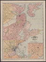
- Beinecke Rare Book and Manuscript Library > Rand, McNally & Co.'s indexed atlas of the world map of Boston.
- Creator:
- Shurtleff, Arthur A. (Arthur Asahel), 1870-1957
- Published / Created:
- [1909]
- Call Number:
- 764 B65 1909D
- Container / Volume:
- BRBL_00456A
- Image Count:
- 1
- Resource Type:
- Maps, Atlases & Globes
- Subject (Topic):
- City planning--Massachusetts--Boston
- Found in:
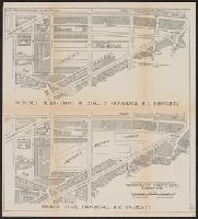
- Beinecke Rare Book and Manuscript Library > [Boston, Mass., Providence R.R. property : proposed redevelopment] / Arthur A. Shurtleff.
- Creator:
- Ensign, Bridgman & Fanning
- Published / Created:
- 1855
- Call Number:
- 76 1855
- Container / Volume:
- BRBL_00445
- Image Count:
- 1
- Resource Type:
- Maps, Atlases & Globes
- Subject (Geographic):
- Massachusetts--Maps
- Subject (Topic):
- Cities and towns--Massachusetts--Maps
- Found in:
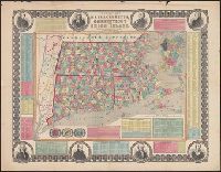
- Beinecke Rare Book and Manuscript Library > Township map of Massachusetts, Connecticut and Rhode Island.
- Creator:
- Ensign, Bridgman & Fanning
- Published / Created:
- 1855
- Call Number:
- 76 1855
- Container / Volume:
- BRBL_00445
- Image Count:
- 1
- Resource Type:
- Maps, Atlases & Globes
- Subject (Geographic):
- Massachusetts--Maps
- Subject (Topic):
- Cities and towns--Massachusetts--Maps
- Found in:
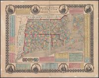
- Beinecke Rare Book and Manuscript Library > Township map of Massachusetts, Connecticut and Rhode Island.
- Creator:
- E.P. Dutton (Firm)
- Published / Created:
- 1865
- Call Number:
- 764 B65 1865
- Container / Volume:
- BRBL_00455
- Image Count:
- 1
- Resource Type:
- Maps, Atlases & Globes
- Subject (Geographic):
- Massachusetts--Maps
- Found in:
- Beinecke Rare Book and Manuscript Library > Chart of Boston Harbor and Massachusetts Bay : with map of the adjacent country / published at the Boston Map Store.
- Published / Created:
- 1781
- Call Number:
- 764cea C17 1781
- Container / Volume:
- BRBL_00461
- Image Count:
- 1
- Resource Type:
- Maps, Atlases & Globes
- Subject (Geographic):
- Massachusetts--Maps--Early works to
- Found in:
- Beinecke Rare Book and Manuscript Library > [A chart of the harbours of Hampton, Newbury, Ipswick, Jebeka, Squam, Cape Ann, Manchester, Beverly, Salem, Marblehead &c. Surveyed by Samuel Holland.
- Creator:
- Aitken, Robert, 1735-1802
- Published / Created:
- 1775]
- Call Number:
- 764 B65 1775N
- Container / Volume:
- BRBL_00455
- Image Count:
- 1
- Resource Type:
- Maps, Atlases & Globes
- Subject (Topic):
- Fortification--Massachusetts--Boston
- Found in:
- Beinecke Rare Book and Manuscript Library > A new and correct plan of the town of Boston.