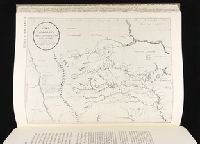
In upper right corner: Gent. Mag., Prime meridian: London., Relief shown pictorially and with hachures., Removed from: Gentleman's magazine. [June 1763]., Sheet measures 20.4 x 26.9 cm. Cross Collection no. 186., and Shows locations of North American Indian tribes.
Publisher:
Gentleman's Magazine,
Subject (Geographic):
MississippiRiver Valley--Maps--Early
Subject (Topic):
Indians of North America--Maps--Early works to 1800
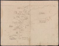
Includes identification of locations and text in ink. Latitude and longitude figures appear in ink and pencil along upper and left margins although they do not correspond to modern measurements., Includes two significant blocks of text: "La Rivière Ohio..." (above) and "L'embouchúre du fleuve Missisipi, que M. de La Salle a descendu le premier iusques a la Mer, ou il arrive le 7 Avril 1682 avec le P. Zenobe Recolles missionaire...du nom de Rio Escondido.", Relief shown pictorially., The map is illustrated in ink and wash with the following vignettes counterclockwide from bottom: native peoples building a boat from felled trees; a roofed structure; a grove of trees; beds; native peoples flipping over an alligator with a pole, and then attacking it with clubs and arrows near a roofed structure; and a small herd of buffalo, labelled "Pisikious ou Boeffs Sauvagees.", The Mississippi River is labelled "Fleuve Missisipi ou Colbert.", The Mississippi River is shown flowing into the western coast of the Gulf of Mexico. The Rivière Ouabache (Wabash) is shown separated from the Ohio., and This map was probably used by Coronelli in his preparation of an improved terrestrial globe for presentation to Louis XIV by Cardinal César d'Estrées, ca. 1683, see the text of the note on the right of the map, "La Rivière Ohio ou Belle rivière ainsi appelée pour sa beauté..." which also appears on Coronelli's globe (see also Pelletier reference).
Subject (Geographic):
MississippiRiver Valley--Maps
Subject (Name):
Coronelli, Vincenzo, 1650-1718
Subject (Topic):
Indians of North America--Maps, Manuscript--Early works to 1800
Includes ill. and text., Lowery refers to this version appearing in Homann's Atlas geographicvs maior exhibens tellurem seu globum terraqueum in mappis generalibus & specialibus ... (1759-[1781]), described in Phillips 622. Cf. Lowery 475., and Reference: Antiq
Includes ill. and text., Lowery refers to this version appearing in Homann's Atlas geographicvs maior exhibens tellurem seu globum terraqueum in mappis generalibus & specialibus ... (1759-[1781]), described in Phillips 622. Cf. Lowery 475., and Reference: Antiq
Includes ill. and text., Lowery refers to this version appearing in Homann's Atlas geographicvs maior exhibens tellurem seu globum terraqueum in mappis generalibus & specialibus ... (1759-[1781]), described in Phillips 622. Cf. Lowery 475., and Reference: Antiq
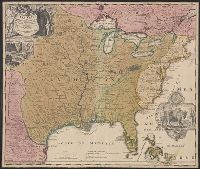
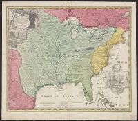
Bar scale given in "echelle de cent lieues Francoises"., Copy 3: Sh, Includes notes., Inset: Carte particuliere des embouchures de la riviere S. Louis et de la Mobile. Scale [ca. 1:2,700,000]., Relief shown pictorially., and Shows some explorers' routes.
Publisher:
Chez Jean Cóvens et Corneille Mortier, geographes,
Subject (Geographic):
MississippiRiver Valley--Maps--Early
Subject (Name):
Cóvens et Mortier. Atlas nouveau and Le Maire, François
Appears in the Cóvens et Mortier's Atlas nouveau, 1730 and later eds., Bar scale given in "echelle de cent lieues Francoises"., Copy 2: With watermark. Sheet measures 54.6 x 63.4 cm., and Inset: Carte particuliere des embouchures de la riviere S. Louis et de la
Publisher:
Chez Jean Cóvens et Corneille Mortier, geographes,
Subject (Geographic):
MississippiRiver Valley--Maps--Early
Subject (Name):
Cóvens et Mortier. Atlas nouveau and Le Maire, François
Appears in the Cóvens et Mortier's Atlas nouveau, 1730 and later eds., Bar scale given in "echelle de cent lieues Francoises"., Copy 1: Bookseller's label: Libreria Loescher e Co. ... Roma. Mounted on linen. Sheet measures 56.5 x 65.8 cm., and Covers eastern Un
Publisher:
Chez Jean Cóvens et Corneille Mortier, geographes,
Subject (Geographic):
MississippiRiver Valley--Maps--Early
Subject (Name):
Cóvens et Mortier. Atlas nouveau and Le Maire, François