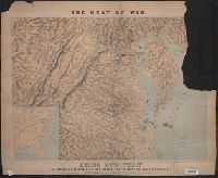
Birds eye view of Virginia, Maryland, Delaware and the District of Columbia
Description:
Bar scales shown in statute miles, nautical miles, and lieues communes de France., Imperfect: Mutilated., Inset: [Gulf of Mexico states] -- [Richmond area]., Relief shown by shading., and Shows railroads.
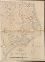
"May 1862.", Does not show military operations., Includes "Table of sounding and tides as given in the U.S.C.S. reports of 1855 & 1857.", and Indicates coastal fortifications, roads, railroads, drainage, canals, swamps, and towns.
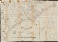
"May 1862.", Does not show military operations., Includes "Table of sounding and tides as given in the U.S.C.S. reports of 1855 & 1857.", Indicates coastal fortifications, roads, railroads, drainage, canals, swamps, and towns., and Lower half of map only.
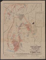
Inset map: "Site of Gen. Gregg's Cavalry Operations. Three Miles east of Gettysburg." "Scale : 1 Inch = 1 Mile.", Legend on map., and Map "Compliments of Zeigler & Holtzworth Livery."
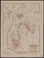
Inset map: "Site of Gen. Gregg's Cavalry Operations. Three Miles east of Gettysburg." "Scale : 1 Inch = 1 Mile.", Legend on map., and Map "Compliments of Zeigler & Holtzworth Livery."
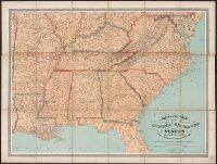
Phelps & Watson's historical and military map of the border and southern states and Phelps and Watson's historical and military map of the border and southern states
Description:
"Entered according to act of Congress, in the year 1862 by Phelps & Watson ....", Includes inset of southern Florida and chronologically arranged list of "Battles of the war" from 1861 to May 1864., Relief shown by hachures., and Shows locations of battles and s