At head of title: No. III. and No. [16] in a v. with binder's title: Reports &c 1 Sess., 8 Cong. (1990 S5 3)
Publisher:
Printed by W. Duane & Son,
Subject (Geographic):
Georgia--Boundaries--Mississippi., Georgia--Politics and government--1775-1865., Mississippi--Boundaries--Georgia., and United States--Politics and government--1783-1809.
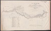
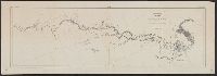
Covers Texas and parts of neighboring states and northern Mexico., From Wislizenus's Memoir of a tour to northern Mexico. Washington : Tippin & Streeper, 1848., Relief shown by hachures., and Shows routes of Gen. Kearny, Gen. Gregg, and Gen. Wool, Spanish military roads, forts, and wagon roads.
Publisher:
Tippin & Streeper,
Subject (Geographic):
Mexican-American Border Region--Maps, Texas--Maps, and West (U.S.)--Maps
Subject (Name):
Edward Weber & Co and Wislizenus, F. A. (Frederick Adolph), 1810-1889. Memoir of a tour to northern Mexico
Covers Texas and parts of neighb, From Wislizenus's Memoir of a tour to northern Mexico. Washington : Tippin & Streeper, 1848., Relief shown by hachures., and Shows routes of Gen. Kearny, Gen. Gregg, and Gen. Wool, Spanish military roads, forts, and wagon roads.
Publisher:
Tippin & Streeper,
Subject (Geographic):
Mexican-American Border Region--Maps, Texas--Maps, and West (U.S.)--Maps
Subject (Name):
Edward Weber & Co and Wislizenus, F. A. (Frederick Adolph), 1810-1889. Memoir of a tour to northern Mexico
"W.J. Peters, Topographer in Charge. Topography by W.J. Peters and Alfred H. Brooks, Assistant Geologist.", At head of map "Map 9.", In upper left-hand corner "U.S. Geological Survey Charles D. Walcott Director.", and In upper right-hand corner "Report, Public Resolution No. 25, 55th Congress, 3D Session."
Publisher:
U.S. Congress],
Subject (Geographic):
Tanana River (Alaska)--Maps and White River (Alaska)--Maps
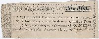
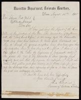
"Report of council with Cheyenne and Arapahoe chiefs and warriors, brought to Denver by Major Wynkoop; taken down by U.S. Indian agent Simeon Whitely as it progressed": 4 p., at end. and "Statement of Mrs. Ewbanks, giving an account of her captivity among the Indians": 1 leaf at end.
Subject (Name):
UnitedStates.--Congress.--Joint
Subject (Topic):
Arapaho Indians--Wars, Cheyenne Indians--Wars, 1864, Indian captivities, Indians of North America--Wars--1862-1865, Indians of North America--Wars--Colorado, and Sand Creek Massacre, Colo., 1864
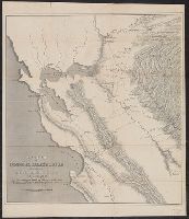
Appears in U.S. 31st Cong., 1st Sess., 1850, House Ex. Doc. no. 17. Message to the President., Library's copy folded in cover 21 x 13 cm. and carries bookplate of Frederick William and Carrie Sperry Beinecke., Relief shown by hachures., and Spine title on Library's copy: Map of General Riley's route, 1849.
Publisher:
U.S. Congress,
Subject (Geographic):
California, Northern--Maps, California--Gold discoveries--Maps, and San Francisco Bay Area (Calif.)--Maps
Subject (Name):
Ackerman Lithr, Beinecke, Carrie Sperry--Bookplate, Beinecke, Frederick W.--Bookplate, Hollingsworth, John McHenry, 1823-1889, and Riley, Bennett,--1787-1853
Subject (Topic):
Gold mines and mining--California--Maps and Mines and mineral resources--California, Northern--Maps