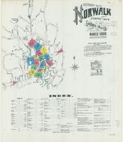
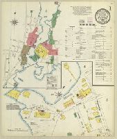
Sanborn fire insurance maps are a rich source of historic data on the urban built environment of North America during the 19th and early 20th centuries. The atlases were created for the purpose of underwriting fire insurance policies, which depended upon accurate and frequently-updated information about construction materials, municipal and transportation infrastructure, industrial and commercial landuse and more. The Yale University Library Map Department scanned its holdings of Sanborn fire insurance maps (consisting primarily of Connecticut towns) in order to make the maps more accessible.
Alternative Title:
Mar. 1906, Norwalk, Conn. and Norwalk, Fairfield Co., Connecticut
Description:
. "Triplicate" stamp on all sheets. Libraryof
Subject (Geographic):
Norwalk (Conn.)--Maps
Subject (Name):
LibraryofCongress Stamp
Subject (Topic):
Fire risk assessment--Connecticut--Norwalk--Maps and Real property--Connecticut--Norwalk--Maps
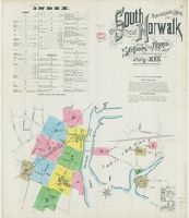
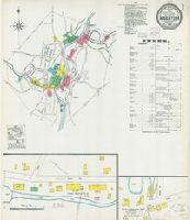
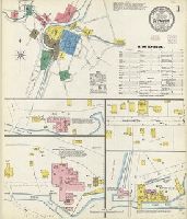
Sanborn fire insurance maps are a rich source of historic data on the urban built environment of North America during the 19th and early 20th centuries. The atlases were created for the purpose of underwriting fire insurance policies, which depended upon accurate and frequently-updated information about construction materials, municipal and transportation infrastructure, industrial and commercial landuse and more. The Yale University Library Map Department scanned its holdings of Sanborn fire insurance maps (consisting primarily of Connecticut towns) in order to make the maps more accessible.
Alternative Title:
July 1895, So. Norwalk, Conn. and South Norwalk, Fairfield Co., Connecticut
Description:
. "Triplicate" stamp on all sheets. Libraryof
Subject (Geographic):
South Norwalk (Norwalk, Conn.)--Maps
Subject (Name):
LibraryofCongress Stamp
Subject (Topic):
Fire risk assessment--Connecticut--Norwalk--South Norwalk--Maps and Real property--Connecticut--Norwalk--South Norwalk--Maps
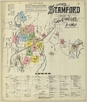
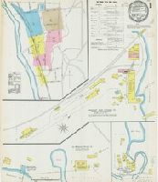
Sanborn fire insurance maps are a rich source of historic data on the urban built environment of North America during the 19th and early 20th centuries. The atlases were created for the purpose of underwriting fire insurance policies, which depended upon accurate and frequently-updated information about construction materials, municipal and transportation infrastructure, industrial and commercial landuse and more. The Yale University Library Map Department scanned its holdings of Sanborn fire insurance maps (consisting primarily of Connecticut towns) in order to make the maps more accessible.
Alternative Title:
Aug. 1896, Stamford, Conn. and Stamford, Fairfield County, Connecticut
Description:
. "Triplicate" stamp on all sheets. Libraryof
Subject (Geographic):
Stamford (Conn.)--Maps
Subject (Name):
LibraryofCongress Stamp
Subject (Topic):
Fire risk assessment--Connecticut--Stamford--Maps and Real property--Connecticut--Stamford--Maps
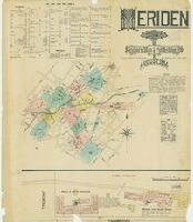
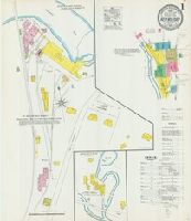
Sanborn fire insurance maps are a rich source of historic data on the urban built environment of North America during the 19th and early 20th centuries. The atlases were created for the purpose of underwriting fire insurance policies, which depended upon accurate and frequently-updated information about construction materials, municipal and transportation infrastructure, industrial and commercial landuse and more. The Yale University Library Map Department scanned its holdings of Sanborn fire insurance maps (consisting primarily of Connecticut towns) in order to make the maps more accessible.
Alternative Title:
Aug. 1884, Meriden, Conn.
Description:
. "Triplicate" stamp on all sheets. Libraryof
Subject (Geographic):
Meriden (Conn.)--Maps
Subject (Name):
LibraryofCongress Stamp
Subject (Topic):
Fire risk assessment--Connecticut--Meriden--Maps and Real property--Connecticut--Meriden--Maps
Sanborn fire insurance maps are a rich source of historic data on the urban built environment of North America during the 19th and early 20th centuries. The atlases were created for the purpose of underwriting fire insurance policies, which depended upon accurate and frequently-updated information about construction materials, municipal and transportation infrastructure, industrial and commercial landuse and more. The Yale University Library Map Department scanned its holdings of Sanborn fire insurance maps (consisting primarily of Connecticut towns) in order to make the maps more accessible.
Alternative Title:
Oct. 1903, Mystic, Conn.
Description:
. "Triplicate" stamp on all sheets. Libraryof
Subject (Geographic):
Mystic (Conn.)--Maps
Subject (Name):
LibraryofCongress Stamp
Subject (Topic):
Fire risk assessment--Connecticut--Mystic--Maps and Real property--Connecticut--Mystic--Maps
Sanborn fire insurance maps are a rich source of historic data on the urban built environment of North America during the 19th and early 20th centuries. The atlases were created for the purpose of underwriting fire insurance policies, which depended upon accurate and frequently-updated information about construction materials, municipal and transportation infrastructure, industrial and commercial landuse and more. The Yale University Library Map Department scanned its holdings of Sanborn fire insurance maps (consisting primarily of Connecticut towns) in order to make the maps more accessible.
Alternative Title:
Feb. 1904, Naugatuck, Conn.
Description:
. "Triplicate" stamp on all sheets. Libraryof
Subject (Geographic):
Naugatuck (Conn.)--Maps
Subject (Name):
LibraryofCongress Stamp
Subject (Topic):
Fire risk assessment--Connecticut--Naugatuck--Maps and Real property--Connecticut--Naugatuck--Maps
Sanborn fire insurance maps are a rich source of historic data on the urban built environment of North America during the 19th and early 20th centuries. The atlases were created for the purpose of underwriting fire insurance policies, which depended upon accurate and frequently-updated information about construction materials, municipal and transportation infrastructure, industrial and commercial landuse and more. The Yale University Library Map Department scanned its holdings of Sanborn fire insurance maps (consisting primarily of Connecticut towns) in order to make the maps more accessible.
Alternative Title:
Dec. 1892, New Milford, Conn.
Description:
. "Triplicate" stamp on all sheets. Libraryof
Subject (Geographic):
New Milford (Conn.)--Maps
Subject (Name):
LibraryofCongress Stamp
Subject (Topic):
Fire risk assessment--Connecticut--New Milford--Maps and Real property--Connecticut--New Milford--Maps
Sanborn fire insurance maps are a rich source of historic data on the urban built environment of North America during the 19th and early 20th centuries. The atlases were created for the purpose of underwriting fire insurance policies, which depended upon accurate and frequently-updated information about construction materials, municipal and transportation infrastructure, industrial and commercial landuse and more. The Yale University Library Map Department scanned its holdings of Sanborn fire insurance maps (consisting primarily of Connecticut towns) in order to make the maps more accessible.
Alternative Title:
Jan. 1904, New Milford, Conn.
Description:
. "Triplicate" stamp on all sheets. Libraryof
Subject (Geographic):
New Milford (Conn.)--Maps
Subject (Name):
LibraryofCongress Stamp
Subject (Topic):
Fire risk assessment--Connecticut--New Milford--Maps and Real property--Connecticut--New Milford--Maps
Sanborn fire insurance maps are a rich source of historic data on the urban built environment of North America during the 19th and early 20th centuries. The atlases were created for the purpose of underwriting fire insurance policies, which depended upon accurate and frequently-updated information about construction materials, municipal and transportation infrastructure, industrial and commercial landuse and more. The Yale University Library Map Department scanned its holdings of Sanborn fire insurance maps (consisting primarily of Connecticut towns) in order to make the maps more accessible.
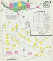
Alternative Title:
Dec. 1903, Rockville, Conn.
Description:
. "Triplicate" stamp on all sheets. Libraryof
Subject (Geographic):
Rockville (Conn.)--Maps
Subject (Name):
LibraryofCongress Stamp
Subject (Topic):
Fire risk assessment--Connecticut--Rockville--Maps and Real property--Connecticut--Rockville--Maps
Sanborn fire insurance maps are a rich source of historic data on the urban built environment of North America during the 19th and early 20th centuries. The atlases were created for the purpose of underwriting fire insurance policies, which depended upon accurate and frequently-updated information about construction materials, municipal and transportation infrastructure, industrial and commercial landuse and more. The Yale University Library Map Department scanned its holdings of Sanborn fire insurance maps (consisting primarily of Connecticut towns) in order to make the maps more accessible.
Alternative Title:
Jan. 1906, Seymour, Conn.
Description:
. "Triplicate" stamp on all sheets. Libraryof
Subject (Geographic):
Seymour (Conn.)--Maps
Subject (Name):
LibraryofCongress Stamp
Subject (Topic):
Fire risk assessment--Connecticut--Seymour--Maps and Real property--Connecticut--Seymour--Maps