Search
You Searched For
Search Results
- Creator:
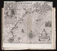
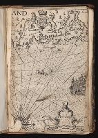
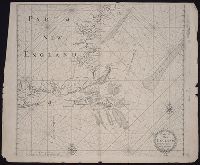
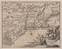
- Clarke, Robert, fl. 1616
Lowe, George, fl. 1613?-ca. 1615?.
Pass, Simon van de, 1595?-1647, engraver.
- Published / Created:
- [1624]
- Call Number:
- Pequot +Sm4
- Collection Title:
- The generall historie of Virginia, New-England, and the Summer Isles : with the names of the
- Image Count:
- 1
- Subject (Geographic):
- New England --History --Colonial period
- Found in:
- Beinecke Rare Book and Manuscript Library > New England.
- Published / Created:
- circa 1995-2017
- Call Number:
- VRC 1990a
- Image Count:
- 3
- Found in:
- Robert B. Haas Family Arts Library Special Collections > Garvin City Planning Image Collection (VRC 1990a) > U.S. Cities > > KANSAS > Kansas City > Quality Hill - McCormick Barron > New England Bldg.
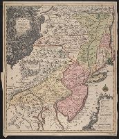
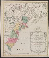
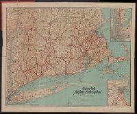
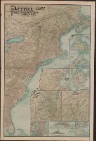
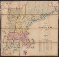
- Published / Created:
- 1857
- Call Number:
- 75gme 1857
- Container / Volume:
- BRBL_00412
- Image Count:
- 2
- Resource Type:
- Maps, Atlases & Globes
- Found in:
- Beinecke Rare Book and Manuscript Library > A new and complete Rail Road map of the United States / compiled from reliable sources by William Perris ; presented by the Home Insurance Company of New York ; Korff Brothers, Practical Lithographers, New York.
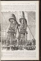
- Creator:
- Centennial Exhibition (1876 : Philadelphia, Pa.)
Leslie, Frank, 1821-1880
Norton, Frank H. (Frank Henry), 1836-1921
- Published / Created:
- 1877
- Call Number:
- 2006 Folio 202
- Image Count:
- 2
- Found in:
- Beinecke Rare Book and Manuscript Library > Frank Leslie's historical register of the United States Centennial exposition, 1876 / embellished with nearly eight hundred illustrations drawn expressly for this work by the most eminent artists in America. ; including illustrations and descriptions of all previous international exhibitions, and containing much useful information, and statistics of the foreign countries represented at the exposition ; edited by Frank H. Norton ...
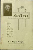
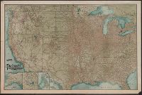
- Published / Created:
- 1900
- Call Number:
- Za C591 W900M
- Image Count:
- 7
- Resource Type:
- Books, Journals & Pamphlets
- Publisher:
- New England Company
- Found in:
- Beinecke Rare Book and Manuscript Library > Mark Twain, printer, pilot, miner, journalist, humorist, traveler, lecturer, novelist [and] publisher.
- Creator:
- Smith, John, 1580-1631
- Published / Created:
- 1631
- Call Number:
- Taylor 316
- Image Count:
- 2
- Alternative Title:
- New England: the most remarqueable
- Description:
- corner: New England ... / observed and
- Subject (Geographic):
- New England--Description and travel
- Found in:
- Beinecke Rare Book and Manuscript Library > Advertisements for the unexperienced planters of New-England, or anywhere, or, The path-way to experience to erect a plantation : With the yearely proceedings of this country in fishing and planting, since the yeare 1614. to the yeare 1630. and their present estate. Also how to prevent the greatest inconveniences, by their proceedings in Virginia, and other plantations, by approved examples. With the countries armes, a description of the coast, harbours, habitations, land-markes, latitude and longitude: with the map, allowed by our royall King Charles. By Captaine Iohn Smith, sometimes governour of Virginia, and admirall of Nevv-England.
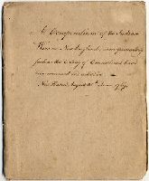
- Creator:
- From the Collection: Trumbull, Benjamin, 1735-1820
- Published / Created:
- 1767
- Call Number:
- MS 505
- Container / Volume:
- Box 1
- Image Count:
- 36
- Description:
- the Indian Wars in New England, more
- Found in:
- Manuscripts and Archives > Benjamin Trumbull papers (MS 505) > Series Accession 2011-M-077: Additional Material > Benjamin Trumbull manuscript, "A Compendium of the Indian Wars in New England, more particularly such as the Colony of Connecticut have been concerned and active in. - New Haven, August 25th. Anno 1767."
- Published / Created:
- 1776]
- Call Number:
- 766 1776
- Container / Volume:
- BRBL_00690
- Image Count:
- 1
- Resource Type:
- Maps, Atlases & Globes
- Found in:
- Beinecke Rare Book and Manuscript Library > A map of Connecticut and Rhode Island with Long Island Sound, &c.
- Published / Created:
- 1776]
- Call Number:
- 766 1776
- Container / Volume:
- BRBL_00690
- Image Count:
- 1
- Resource Type:
- Maps, Atlases & Globes
- Found in:
- Beinecke Rare Book and Manuscript Library > A map of Connecticut and Rhode Island with Long Island Sound, &c.
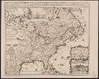
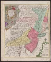
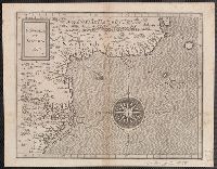
- Creator:
- Tirion, Isaak
- Published / Created:
- [1769]
- Call Number:
- 755 1755F
- Container / Volume:
- BRBL_00427
- Image Count:
- 1
- Resource Type:
- Maps, Atlases & Globes
- Found in:
- Beinecke Rare Book and Manuscript Library > Nieuwe kaart van de grootbrittannische Volkplantingen in Noort America .../ Isaak Tirion 1755.
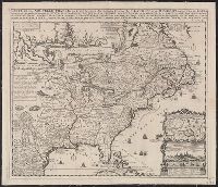
- Creator:
- Tirion, Isaak
- Published / Created:
- [1769]
- Call Number:
- 755 1755Z
- Container / Volume:
- BRBL_00427
- Image Count:
- 1
- Resource Type:
- Maps, Atlases & Globes
- Found in:
- Beinecke Rare Book and Manuscript Library > Nieuwe kaart van de grootbrittannische Volkplantingen in Noort America .../ Isaak Tirion 1755.
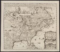
- Creator:
- Robert Sayer and John Bennett (Firm)
- Call Number:
- 755 1776K
- Container / Volume:
- BRBL_00430
- Image Count:
- 1
- Resource Type:
- Maps, Atlases & Globes
- Alternative Title:
- , Nova-Scotia, New-England, New-York, New
- Subject (Geographic):
- New England--Maps--Early works to 1800
- Found in:
- Beinecke Rare Book and Manuscript Library > A general map of the northern British colonies in America : which comprehends the province of Quebec, the government of Newfoundland, Nova-Scotia, New-England and New-York, from the maps published by the Admiralty and Board of Trade, regulated by the astr
- Creator:
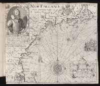
- Lowe, George, fl. 1613?-ca. 1615?, printer
Pass, Simon van de, 1595?-1647, engraver.
- Published / Created:
- 1624
- Call Number:
- 2003 +39
- Collection Title:
- The generall historie of Virginia, New-England, and the Summer Iles ...
- Image Count:
- 1
- Subject (Geographic):
- New England--Maps--Early works to 1800
- Subject (Topic):
- New England--History--Colonial period
- Found in:
- Beinecke Rare Book and Manuscript Library > New England
- Published / Created:
- [1755?]
- Call Number:
- 71 1755G
- Container / Volume:
- BRBL_00363
- Image Count:
- 1
- Resource Type:
- Maps, Atlases & Globes
- Subject (Geographic):
- New England--Maps--Early works to 1800
- Found in:
- Beinecke Rare Book and Manuscript Library > Carta d'una parte dell' America Settentrionale : che serve per ben poter intendere le pretensioni delli Inglesi, esposte ne loro memoriali in occasione della regolazione de limiti con la Francia nell' America svdetta.
- Creator:
- Fer, Nicolas de, 1646-1720
- Published / Created:
- 1719?]
- Call Number:
- 71 1719B
- Container / Volume:
- BRBL_00687
- Image Count:
- 1
- Resource Type:
- Maps, Atlases & Globes
- Found in:
- Beinecke Rare Book and Manuscript Library > Carte de la Nouvelle France : où se voit le cours des grandes rivieres de S. Laurens & de Mississipi, aujour d'hui S. Louïs, aux environs des-quelles se trouvent les etats, païs, nations, peuples &c. de la Floride, de la Louïsiane, de la Virginie, de
- Creator:
- Fer, Nicolas de, 1646-1720
- Published / Created:
- 1719?]
- Call Number:
- 71 1719B
- Container / Volume:
- BRBL_00361
- Image Count:
- 1
- Resource Type:
- Maps, Atlases & Globes
- Found in:
- Beinecke Rare Book and Manuscript Library > Carte de la Nouvelle France : où se voit le cours des grandes rivieres de S. Laurens & de Mississipi, aujour d'hui S. Louïs, aux environs des-quelles se trouvent les etats, païs, nations, peuples &c. de la Floride, de la Louïsiane, de la Virginie, de
- Creator:
- Adams, A[r]thur
- Call Number:
- Cg4 35
- Collection Title:
- A compendious history of New England : designed for schools and private families / By Jedidiah
- Image Count:
- 1
- Subject (Geographic):
- New England --History --Colonial period
- Found in:
- Beinecke Rare Book and Manuscript Library > New England
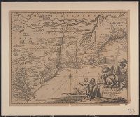
- Creator:
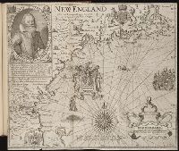
- Lowe, George, fl. 1613?-ca. 1615?.
Pass, Simon van de, 1595?-1647, engraver
- Published / Created:
- [1624?]
- Call Number:
- Taylor 301
- Collection Title:
- The generall historie of Virginia, New-England, and the Summer Iles : with the names of the
- Image Count:
- 1
- Subject (Geographic):
- New England --History --Colonial period
- Found in:
- Beinecke Rare Book and Manuscript Library > New England
- Published / Created:
- [1632]
- Call Number:
- Z40 026
- Collection Title:
- The generall historie of Virginia, New-England, and the Summer Isles : with the names of the
- Image Count:
- 1
- Subject (Geographic):
- New England --History --Colonial period
- Found in:
- Beinecke Rare Book and Manuscript Library > [New England]
- Creator:
- Pass, Simon van de, 1595?-1647, engraver
Reeve, James, printer.
- Published / Created:
- [1632]
- Call Number:
- Taylor 320
- Collection Title:
- The generall historie of Virginia, New-England, and the Summer Isles : with the names of the
- Image Count:
- 1
- Subject (Geographic):
- New England --History --Colonial period
- Found in:
- Beinecke Rare Book and Manuscript Library > New England.
- Creator:
- Clarke, Robert, fl. 1616
Pass, Simon van de, 1595?-1647, engraver.
Reeve, James, printer.
- Published / Created:
- [1632]
- Call Number:
- Vanderbilt +145
- Collection Title:
- The generall historie of Virginia, New-England, and the Summer Isles : with the names of the
- Image Count:
- 1
- Subject (Geographic):
- New England --History --Colonial period
- Found in:
- Beinecke Rare Book and Manuscript Library > New England.
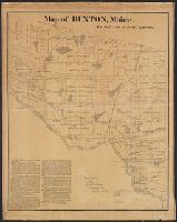
- Published / Created:
- 1871
- Call Number:
- 761 B98 1870
- Container / Volume:
- BRBL_00448
- Image Count:
- 1
- Resource Type:
- Maps, Atlases & Globes
- Publisher:
- New England Lith. Co. ,
- Found in:
- Beinecke Rare Book and Manuscript Library > Map of Buxton, Maine / by Daniel Dennet, 1870.
- Published / Created:
- circa 1750-2001
- Call Number:
- RU 684
- Container / Volume:
- Box 34, folder 1239
- Image Count:
- 1
- Found in:
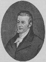
- Manuscripts and Archives > Images of Yale individuals (RU 684) > Series I: Alphabetical List of Individuals > Hopkins, Samuel Miles (1791)
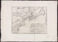
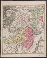
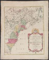
- Published / Created:
- [1774]
- Call Number:
- 76 1774
- Container / Volume:
- BRBL_00729
- Image Count:
- 1
- Resource Type:
- Maps, Atlases & Globes
- Abstract:
- Subject: Map of New England and Long
- Subject (Geographic):
- New England--Maps
- Found in:
- Beinecke Rare Book and Manuscript Library > A Map of the most inhabited part of New England [cartographic material] : containing the provinces of Massachusets Bay and New Hampshire with the colonies of Conecticut and Rhode Island divided into counties and townships : The whole composed from actual
- Published / Created:
- [1774]
- Call Number:
- 76 1774
- Container / Volume:
- BRBL_00729
- Image Count:
- 2
- Resource Type:
- Maps, Atlases & Globes
- Abstract:
- Subject: Map of New England and Long
- Subject (Geographic):
- New England--Maps
- Found in:
- Beinecke Rare Book and Manuscript Library > A Map of the most inhabited part of New England [cartographic material] : containing the provinces of Massachusets Bay and New Hampshire with the colonies of Conecticut and Rhode Island divided into counties and townships : The whole composed from actual
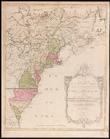
- Published / Created:
- [1774]
- Call Number:
- 76 1774
- Container / Volume:
- BRBL_00443
- Image Count:
- 2
- Resource Type:
- Maps, Atlases & Globes
- Abstract:
- Subject: Map of New England and Long
- Subject (Geographic):
- New England--Maps
- Found in:
- Beinecke Rare Book and Manuscript Library > A Map of the most inhabited part of New England [cartographic material] : containing the provinces of Massachusets Bay and New Hampshire with the colonies of Conecticut and Rhode Island divided into counties and townships : The whole composed from actual
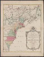
- Published / Created:
- [1774]
- Call Number:
- 76 1774
- Container / Volume:
- BRBL_00443
- Image Count:
- 2
- Resource Type:
- Maps, Atlases & Globes
- Abstract:
- Subject: Map of New England and Long
- Subject (Geographic):
- New England--Maps
- Found in:
- Beinecke Rare Book and Manuscript Library > A Map of the most inhabited part of New England [cartographic material] : containing the provinces of Massachusets Bay and New Hampshire with the colonies of Conecticut and Rhode Island divided into counties and townships : The whole composed from actual
- Creator:
- From the Collection: Dreier, Katherine S. (Katherine Sophie), 1877-1952
- Published / Created:
- undated
- Call Number:
- YCAL MSS 101
- Container / Volume:
- Box 70, folder 1808
- Image Count:
- 20
- Found in:
- Beinecke Rare Book and Manuscript Library > Katherine S. Dreier papers / Société Anonyme archive (YCAL MSS 101) > Series V: Katherine S. Dreier: Photographs & Artwork > > PHOTOGRAPHS > Katherine S. Dreier > Haven (West Redding, Conn.) > Main entrance, front view (2 prints taped together); From main entrance looking toward Long Ridge Methodist Episcopal Church (West Redding, Conn.); From main entrance looking toward garden; Trellises in garden; Fountain in garden; Pond in garden; Stone wall in garden; Brancusi's "Leda" in garden; West porch; West porch and old section of house
- Creator:
- Lotter, Tobias Conrad, 1717-1777
- Published / Created:
- 1760?]
- Call Number:
- 755 1760E
- Container / Volume:
- BRBL_00428
- Image Count:
- 1
- Resource Type:
- Maps, Atlases & Globes
- Description:
- Also covers New England (distorted) and
- Subject (Geographic):
- New England--Maps--Early works to 1800
- Found in:
- Beinecke Rare Book and Manuscript Library > Pensylvania, Nova Jersey et Nova York cum regionibus ad Fluvium Delaware in America sitis / nova delineatione ob oculos posita per Tob. Conr. Lotter, geographum Aug. Vind. ; Tob. Conr. Lotter sculps. Aug. V.
- Creator:
- Homann, Johann Baptist, 1663-1724
- Published / Created:
- 1716?]
- Call Number:
- 76 1759
- Container / Volume:
- BRBL_00729
- Image Count:
- 1
- Resource Type:
- Maps, Atlases & Globes
- Description:
- New England.
- Subject (Geographic):
- New England--Maps--Early works to 1800
- Found in:
- Beinecke Rare Book and Manuscript Library > Nova Anglia septentrionali Americae implantata Anglorumque coloniis florentissima geographice exhibita / [cartographic material] / a Ioh. Baptista Homann ...
- Creator:
- Lotter, Tobias Conrad, 1717-1777
- Published / Created:
- 1760?]
- Call Number:
- 755 1760E
- Container / Volume:
- BRBL_00728
- Image Count:
- 1
- Resource Type:
- Maps, Atlases & Globes
- Description:
- Also covers New England (distorted) and
- Subject (Geographic):
- New England--Maps--Early works to 1800
- Found in:
- Beinecke Rare Book and Manuscript Library > Pensylvania, Nova Jersey et Nova York cum regionibus ad Fluvium Delaware in America sitis / nova delineatione ob oculos posita per Tob. Conr. Lotter, geographum Aug. Vind. ; Tob. Conr. Lotter sculps. Aug. V.
- Creator:
- From the Collection: New England Grenfell Association
- Published / Created:
- 1912-1977
- Call Number:
- MS 1200
- Container / Volume:
- Box 5, folder 51
- Image Count:
- 1
- Found in:
- Manuscripts and Archives > New England Grenfell Association records (MS 1200) > Series I: Office Files > Memorabilia
- Creator:
- Lotter, Tobias Conrad, 1717-1777
- Published / Created:
- 1760?]
- Call Number:
- 75 1730
- Container / Volume:
- BRBL_00689
- Image Count:
- 1
- Resource Type:
- Maps, Atlases & Globes
- Description:
- Also covers New England (distorted) and
- Subject (Geographic):
- New England--Maps--Early works to 1800
- Found in:
- Beinecke Rare Book and Manuscript Library > Pensylvania, Nova Jersey et Nova York cum regionibus ad Fluvium Delaware in America sitis / nova delineatione ob oculos posita per Tob. Conr. Lotter, geographum Aug. Vind. ; Tob. Conr. Lotter sculps. Aug. V.
- Creator:
- Kitchin, Thomas, d. 1784
- Published / Created:
- 1778
- Call Number:
- 76 1778
- Container / Volume:
- BRBL_00690
- Image Count:
- 2
- Resource Type:
- Maps, Atlases & Globes
- Subject (Geographic):
- New England--Maps--Early works to 1800
- Found in:
- Beinecke Rare Book and Manuscript Library > A map of the colony of Rhode Island [cartographic material] : with the adjacent parts of Connecticut, Massachusetts Bay, & c / by Thos. Kitchin Senr., Hydrographer to His Majesty.
- Creator:
- Bowen, Emanuel, d. 1767
- Published / Created:
- 1754
- Call Number:
- 75 1720
- Container / Volume:
- BRBL_00689
- Image Count:
- 1
- Resource Type:
- Maps, Atlases & Globes
- Found in:
- Beinecke Rare Book and Manuscript Library > A map of the British American plantations [cartographic material] : extending from Boston in New England to Georgia, including all the back settlements in the respective provinces, as far as the Mississippi / by Eman. Bowen Geogr. to His Majesty ; Tho. Bo
- Creator:
- Lotter, Matthäus Albrecht, 1741-1810
- Published / Created:
- 1776?]
- Call Number:
- 755 1778D
- Container / Volume:
- BRBL_00432
- Image Count:
- 1
- Resource Type:
- Maps, Atlases & Globes
- Found in:
- Beinecke Rare Book and Manuscript Library > Carte nouvelle de l'Amérique angloise contenant tout ce que les Anglois possedent sur le continent de l'Amérique septentrionale savoir le Canada : la Nouvelle Ecosse ou Acadie, les treize provinces unies qui font : les quatres colonies de la Nouvelle An
- Creator:
- Lotter, Matthäus Albrecht, 1741-1810.
- Published / Created:
- 1776?]
- Call Number:
- 755 1776E
- Image Count:
- 1
- Resource Type:
- Maps, Atlases & Globes
- Found in:
- Beinecke Rare Book and Manuscript Library > Carte nouvelle de l'Amérique angloise contenant tout ce que les Anglois possedent sur le continent de l'Amérique septentrionale savoir le Canada : la Nouvelle Ecosse ou Acadie, les treize provinces unies qui font : les quatres colonies de la Nouvelle Angleterre ... / gravée exactement d'après les determinations geographiques dernierement faites par Matthieu Albert Lotter.
- Creator:
- Lotter, Matthäus Albrecht, 1741-1810
- Published / Created:
- 1776?]
- Call Number:
- 755 1778
- Container / Volume:
- BRBL_00690
- Image Count:
- 1
- Resource Type:
- Maps, Atlases & Globes
- Found in:
- Beinecke Rare Book and Manuscript Library > Carte nouvelle de l'Amérique angloise contenant tout ce que les Anglois possedent sur le continent de l'Amérique septentrionale savoir le Canada : la Nouvelle Ecosse ou Acadie, les treize provinces unies qui font : les quatres colonies de la Nouvelle An
- Published / Created:
- ca. 1747?]
- Call Number:
- 771 1760
- Container / Volume:
- BRBL_00690
- Image Count:
- 1
- Resource Type:
- Maps, Atlases & Globes
- Found in:
- Beinecke Rare Book and Manuscript Library > Map of Hudson's River, with the adjacent country [cartographic material].
- Creator:
- Lotter, Matthäus Albrecht, 1741-1810
- Published / Created:
- 1776?]
- Call Number:
- 755 1776E
- Container / Volume:
- BRBL_00430
- Image Count:
- 1
- Resource Type:
- Maps, Atlases & Globes
- Found in:
- Beinecke Rare Book and Manuscript Library > Carte nouvelle de l'Amérique angloise contenant tout ce que les Anglois possedent sur le continent de l'Amérique septentrionale savoir le Canada : la Nouvelle Ecosse ou Acadie, les treize provinces unies qui font : les quatres colonies de la Nouvelle An
- Creator:
- Lotter, Matthäus Albrecht, 1741-1810
- Published / Created:
- 1776?]
- Call Number:
- 71 1776L
- Container / Volume:
- BRBL_00726
- Image Count:
- 1
- Resource Type:
- Maps, Atlases & Globes
- Found in:
- Beinecke Rare Book and Manuscript Library > Carte nouvelle de l'Amérique angloise contenant tout ce que les Anglois possedent sur le continent de l'Amérique septentrionale savoir le Canada : la Nouvelle Ecosse ou Acadie, les treize provinces unies qui font : les quatres colonies de la Nouvelle An
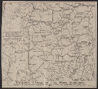
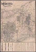
- Published / Created:
- 1917
- Call Number:
- 762gmb 1917
- Container / Volume:
- BRBL_00451
- Image Count:
- 1
- Resource Type:
- Maps, Atlases & Globes
- Description:
- Inset: Key map of New England showing
- Found in:
- Beinecke Rare Book and Manuscript Library > Through trails in the White Mountains : maintained by the organizations comprising the New England Trail Conference.
- Published / Created:
- circa 1995-2017
- Call Number:
- VRC 1990a
- Image Count:
- 5
- Found in:
- Robert B. Haas Family Arts Library Special Collections > Garvin City Planning Image Collection (VRC 1990a) > U.S. Cities > KANSAS > Kansas City > NY Life Bldg. (MMW)
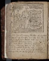
- Published / Created:
- 1767
- Call Number:
- Lxi8 N4 1
- Collection Title:
- The New-England primer improved : For the more easy attaining the true reading of English. : To
- Image Count:
- 1
- Resource Type:
- Books, Journals & Pamphlets
- Found in:
- Beinecke Rare Book and Manuscript Library > New England primer
- Creator:
- From the Collection: Marsh, Othniel Charles, 1831-1899
- Published / Created:
- 1898
- Call Number:
- MS 343
- Container / Volume:
- Box 24, folder 990A
- Image Count:
- 1
- Found in:
- Manuscripts and Archives > Othniel Charles Marsh papers (MS 343) > Series I: General correspondence > New England Magazine
- Creator:
- From the Collection: Dunbar, Rudolph, 1899-1988
- Published / Created:
- 1978
- Call Number:
- JWJ MSS 174
- Container / Volume:
- Box 2, folder 48
- Image Count:
- 6
- Found in:
- Beinecke Rare Book and Manuscript Library > Rudolph Dunbar Papers (JWJ MSS 174) > Series II: Professional Papers > Periodical New England
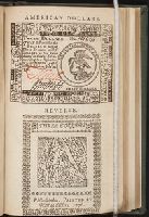
- Published / Created:
- 1776
- Call Number:
- 1995 370
- Collection Title:
- Travels through the interior parts of America. In a series of letters. By an officer ...
- Image Count:
- 1
- Subject (Name):
- United Colonies of New England
- Found in:
- Beinecke Rare Book and Manuscript Library > American dollars
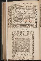
- Creator:
- Wells, Edward, 1667-1727
- Published / Created:
- 1722?]
- Call Number:
- 755 1722
- Container / Volume:
- BRBL_00425
- Image Count:
- 1
- Resource Type:
- Maps, Atlases & Globes
- Found in:
- Beinecke Rare Book and Manuscript Library > A new map of the most considerable plantations of the English in America : dedicated to His Highness William Duke of Glocester / Sutton Nichols sculp.
- Call Number:
- EEg 671P
- Collection Title:
- America: being the latest, and most accurate description of the New world; containing the original
- Image Count:
- 1
- Description:
- Associated with Chap. II, New England
- Subject (Geographic):
- New England --Description and travel
- Found in:
- Beinecke Rare Book and Manuscript Library > [Description of New England]
- Creator:
- Ely, William Watson
- Published / Created:
- 1878
- Call Number:
- 771 Ad47 1878
- Container / Volume:
- BRBL_00480
- Image Count:
- 1
- Resource Type:
- Maps, Atlases & Globes
- Description:
- Inset map of New York State and New
- Subject (Geographic):
- New England--Maps
- Found in:
- Beinecke Rare Book and Manuscript Library > Map of the New York Wilderness and the Adirondacks.
- Creator:
- Homann, Johann Baptist, 1663-1724
- Published / Created:
- 1759?]
- Call Number:
- 755 1759A
- Container / Volume:
- BRBL_00428
- Image Count:
- 1
- Resource Type:
- Maps, Atlases & Globes
- Description:
- Cf. McCorkle, B.B. New England in early
- Subject (Geographic):
- New England--Maps--Early works to 1800
- Found in:
- Beinecke Rare Book and Manuscript Library > Nova Anglia septentrionali Americae implantata Anglorumque coloniis florentissima geographice exhibita / [cartographic material] / a Ioh. Baptista Homann ...
- Call Number:
- 1973 Folio 76
- Collection Title:
- of New-found-land, New-England, New-York, Dellewar-Bay, Virginia, Mary-land and Carrolina, &c
- Image Count:
- 1
- Subject (Geographic):
- New England --Maps --Early works to
- Found in:
- Beinecke Rare Book and Manuscript Library > Part of New England
- Creator:
- Overton, Henry, 1675 or 6-1751
- Published / Created:
- [1755?]
- Call Number:
- 755 1756F
- Container / Volume:
- BRBL_00428
- Image Count:
- 1
- Resource Type:
- Maps, Atlases & Globes
- Found in:
- Beinecke Rare Book and Manuscript Library > An accurate map of the British colonies in North America bordering on the river Ohio.
- Creator:
- Thornton, John, fl. 1652-1701
- Published / Created:
- [1673?]
- Call Number:
- 755 1682B
- Container / Volume:
- BRBL_00424
- Image Count:
- 1
- Resource Type:
- Maps, Atlases & Globes
- Alternative Title:
- , New-York & New England
- Description:
- Inset: "A mapp of New England".
- Subject (Geographic):
- New England--Maps--Early works to 1800
- Found in:
- Beinecke Rare Book and Manuscript Library > A mapp of Virginia, Mary-land, New-Jarsey, New-York, & New England.
- Creator:
- Morden, Robert, d. 1703
- Published / Created:
- [1676?]
- Call Number:
- 755 1675E
- Container / Volume:
- BRBL_00423
- Image Count:
- 1
- Resource Type:
- Maps, Atlases & Globes
- Alternative Title:
- Map of New England, New Yorke, New
- Subject (Geographic):
- New England--Maps--Early works to 1800
- Found in:
- Beinecke Rare Book and Manuscript Library > A map of New England, New Yorke, New Jersey, Mary-land & Virginia / Gr. King sculpsit.
- Creator:
- Speed, John, 1552?-1629
- Published / Created:
- [1676]
- Call Number:
- 755 1672A
- Container / Volume:
- BRBL_00423
- Image Count:
- 2
- Resource Type:
- Maps, Atlases & Globes
- Subject (Geographic):
- New England--Maps--Early works to 1800
- Found in:
- Beinecke Rare Book and Manuscript Library > A map of New England and New York / F. Lamb sculp.
- Creator:
- Seller, John, fl. 1658-1698
- Published / Created:
- 1675?]
- Call Number:
- 755cea 1675
- Container / Volume:
- BRBL_00441
- Image Count:
- 1
- Resource Type:
- Maps, Atlases & Globes
- Subject (Geographic):
- New England--Nautical charts--Early
- Found in:
- Beinecke Rare Book and Manuscript Library > A chart of the sea coasts of New-England, New-Jarsey, Virginia, Maryland and Carolina : from C. Cod to C. Hatteras / by John Seller, hydrogr. to the King ; Iames Clerk sculpsit.
- Creator:
- Kitchin, Thomas, d. 1784
- Published / Created:
- 1780?]
- Call Number:
- 755 1760
- Container / Volume:
- BRBL_00428
- Image Count:
- 1
- Resource Type:
- Maps, Atlases & Globes
- Found in:
- Beinecke Rare Book and Manuscript Library > British dominions in America : drawn from the latest and best authorities / by Thos. Kitchin, hydrographer to his majesty.
- Creator:
- Kitchin, Thomas, d. 1784
- Published / Created:
- 1766?]
- Call Number:
- 755 1763A
- Container / Volume:
- BRBL_00428
- Image Count:
- 1
- Resource Type:
- Maps, Atlases & Globes
- Found in:
- Beinecke Rare Book and Manuscript Library > A new and accurate map of the British dominions in America, according to the Treaty of 1763, divided into the several provinces and jurisdictions : projected upon the best authorities and astronomical observations / by Thos. Kitchin, geographer.
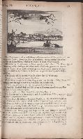
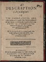
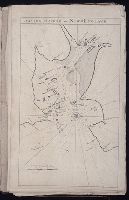
- Creator:
- Smith, John, 1580-1631
- Published / Created:
- 1616
- Call Number:
- Taylor 269
- Image Count:
- 3
- Resource Type:
- Books, Journals & Pamphlets
- Description:
- Smith's map of New England in the 9th state
- Subject (Geographic):
- New England -- Maps -- Early works to
- Found in:
- Beinecke Rare Book and Manuscript Library > A description of New-England: or The observations and discoueries, of Captain Iohn Smith, (admirall of that country) in the north of America in the year of our Lord 1614, with the successe of sixe ships that went the next yeare 1615; and the accidents befell him among the French men of warre: with the proofe of the present benefit this countrey affoords: whither this present yeare, 1616, eight voluntary ships are gone to make further tryall.
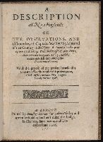
- Creator:
- Smith, John, 1580-1631
- Published / Created:
- 1616
- Call Number:
- CF7 S65 1616
- Image Count:
- 3
- Resource Type:
- Books, Journals & Pamphlets
- Description:
- Smith's map of New England in the 4th state
- Subject (Geographic):
- New England -- Maps -- Early works to
- Found in:
- Beinecke Rare Book and Manuscript Library > A description of New-England: or The observations and discoueries, of Captain Iohn Smith, (admirall of that country) in the north of America in the year of our Lord 1614, with the successe of sixe ships that went the next yeare 1615; and the accidents befell him among the French men of warre: with the proofe of the present benefit this countrey affoords: whither this present yeare, 1616, eight voluntary ships are gone to make further tryall.
- Creator:
- Montanus, Arnoldus, 1625?-1683
- Published / Created:
- 1671?]
- Call Number:
- 755 1671B
- Container / Volume:
- BRBL_00680
- Image Count:
- 1
- Resource Type:
- Maps, Atlases & Globes
- Subject (Geographic):
- New England--Maps--Early works to 1800
- Found in:
- Beinecke Rare Book and Manuscript Library > Novi Belgii, quod nunc Novi Jorck vocatur, Novae q[ue] Angliae & partis Virginiae : accuratissima et novissima delineatio.
- Creator:
- Montanus, Arnoldus, 1625?-1683
- Published / Created:
- 1671?]
- Call Number:
- 755 1671B
- Container / Volume:
- BRBL_00423
- Image Count:
- 1
- Resource Type:
- Maps, Atlases & Globes
- Subject (Geographic):
- New England--Maps--Early works to 1800
- Found in:
- Beinecke Rare Book and Manuscript Library > Novi Belgii, quod nunc Novi Jorck vocatur, Novae q[ue] Angliae & partis Virginiae : accuratissima et novissima delineatio.
- Call Number:
- 1973 Folio 76
- Collection Title:
- of New-found-land, New-England, New-York, Dellewar-Bay, Virginia, Mary-land and Carrolina, &c
- Image Count:
- 1
- Found in:
- Beinecke Rare Book and Manuscript Library > Boston Harbor in New-England
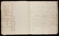
- Creator:
- Stiles, Ezra, 1727-1795
- Published / Created:
- 1760
- Image Count:
- 1
- Resource Type:
- Archives or Manuscripts
- Subject (Geographic):
- America -- New England
- Found in:
- Beinecke Rare Book and Manuscript Library > Census of New England Tribes
- Creator:
- Wytfliet, Corneille
- Published / Created:
- 1597
- Call Number:
- 755 1597
- Container / Volume:
- BRBL_00728
- Image Count:
- 1
- Resource Type:
- Maps, Atlases & Globes
- Found in:
- Beinecke Rare Book and Manuscript Library > Norumbega et Virginia, 1597 [cartographic material].
- Creator:
- Poole Brothers
- Published / Created:
- [1903]
- Call Number:
- 76gme 1903
- Container / Volume:
- BRBL_00446A
- Image Count:
- 1
- Resource Type:
- Maps, Atlases & Globes
- Subject (Topic):
- Ferries--New England--Maps
- Found in:
- Beinecke Rare Book and Manuscript Library > The New York, New Haven and Hartford Railroad and connections.
- Creator:
- H.H. Lloyd & Co
- Published / Created:
- c1855.
- Call Number:
- 753 1855
- Container / Volume:
- BRBL_00415
- Image Count:
- 1
- Resource Type:
- Maps, Atlases & Globes
- Alternative Title:
- Tourist's map of New York, New England
- Description:
- , New England, and Canada.
- Subject (Geographic):
- New England--Maps
- Found in:
- Beinecke Rare Book and Manuscript Library > Lloyd's map of the Canadas, New York, & New England.
- Creator:
- Homann, Johann Baptist, 1663-1724
- Published / Created:
- 1759?]
- Call Number:
- 75 1710
- Container / Volume:
- BRBL_00689
- Image Count:
- 1
- Resource Type:
- Maps, Atlases & Globes
- Description:
- Cf. McCorkle, B.B. New England in early
- Subject (Geographic):
- New England--Maps--Early works to 1800
- Found in:
- Beinecke Rare Book and Manuscript Library > Nova Anglia septentrionali Americae implantata Anglorumque coloniis florentissima geographice exhibita / [cartographic material] / a Ioh. Baptista Homann ...
- Creator:
- Seller, John, fl. 1658-1698
- Published / Created:
- [1675]
- Call Number:
- 76 1675
- Image Count:
- 1
- Resource Type:
- Maps, Atlases & Globes
- Description:
- : A description of New-England (4 p. ; 46
- Subject (Geographic):
- New England--Maps--Early works to 1800
- Found in:
- Beinecke Rare Book and Manuscript Library > A mapp of New England / by John Seller, hydrographer to the King.
- Creator:
- Home Educator Company.
- Published / Created:
- c1905.
- Call Number:
- 76gm 1905
- Image Count:
- 1
- Resource Type:
- Maps, Atlases & Globes
- Description:
- larger cities and towns of New England.
- Subject (Geographic):
- New England--Maps.
- Subject (Topic):
- Electric railroads--New England--Maps.
- Found in:
- Beinecke Rare Book and Manuscript Library > The New England commercial and route survey [cartographic material] : showing all postoffices, railroads, electric roads in operation and proposed, good roads, population (showing latest Massachusetts census) and a comprehensive distance table.
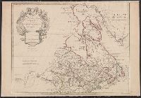
- Published / Created:
- 1783
- Call Number:
- 755 1783
- Container / Volume:
- BRBL_00434
- Image Count:
- 1
- Resource Type:
- Maps, Atlases & Globes
- Description:
- Canada with "Etats Unis" added across New
- Found in:
- Beinecke Rare Book and Manuscript Library > Carte du Canada qui comprend la partie septentrionale des Etats-Unis d'Amerique ... par Guillaume Del'Isle ...
- Creator:
- New England Railway Publishing Company
- Published / Created:
- c1901.
- Call Number:
- 75gme 1902A
- Container / Volume:
- BRBL_00414
- Image Count:
- 1
- Resource Type:
- Maps, Atlases & Globes
- Found in:
- Beinecke Rare Book and Manuscript Library > The ABC Pathfinder Railway Guide, Eastern Section / issued by the New England Railway Publishing Company.
- Creator:
- New England Railway Publishing Company
- Published / Created:
- c1902.
- Call Number:
- 75gme 1902B
- Container / Volume:
- BRBL_00414
- Image Count:
- 1
- Resource Type:
- Maps, Atlases & Globes
- Found in:
- Beinecke Rare Book and Manuscript Library > The ABC Pathfinder Railway Guide, Western Section / issued by the New England Railway Publishing Company.
- Creator:
- Kitchin, Thomas, 1718-1784
- Published / Created:
- 1756
- Call Number:
- 755 1765A
- Container / Volume:
- BRBL_00690
- Image Count:
- 1
- Resource Type:
- Maps, Atlases & Globes
- Found in:
- Beinecke Rare Book and Manuscript Library > A map of the eastern part of the Province of New York : with part of New Jersey &c. / drawn from the best authorities by T. Kitchin geogr.
- Creator:
- National Publishing Company (Boston, Mass.)
- Published / Created:
- 1898
- Call Number:
- 76 1898
- Container / Volume:
- BRBL_00445
- Image Count:
- 1
- Resource Type:
- Maps, Atlases & Globes
- Alternative Title:
- Map of New England showing state
- Subject (Geographic):
- New England--Maps
- Subject (Topic):
- Post Office Buildings--New England
- Found in:
- Beinecke Rare Book and Manuscript Library > New post office, township, county and railroad map of New England : with distances.
- Creator:
- Blaskowitz, Charles
- Published / Created:
- 1777.
- Call Number:
- Drawer 777.07.22.01+
- Image Count:
- 1
- Found in:
- Lewis Walpole Library > A topographical chart of the bay of Narraganset in the province of New England : with all the isles contained therein, among which Rhode Island and Connonicut have been particularly surveyed, shewing the true position & bearings of the banks, shoals, rocks &c. as likewise the soundings: To which have been added the several works & batteries raised by the Americans. Taken by order of the principal farmers on Rhode Island
- Creator:
- Stiles, Ezra, 1727-1795
- Published / Created:
- October 1761
- Image Count:
- 1
- Resource Type:
- Archives or Manuscripts
- Found in:
- Beinecke Rare Book and Manuscript Library > Stiles' Notes on New England Indians
- Creator:
- From the Collection: Stiles, Ezra, 1727-1795
- Published / Created:
- undated
- Call Number:
- GEN MSS 1475
- Container / Volume:
- Box 86 (Oversize), folder 3189
- Image Count:
- 1
- Found in:
- Beinecke Rare Book and Manuscript Library > Ezra Stiles Papers (GEN MSS 1475) > Series V: Miscellaneous Volumes and Papers > Undated Papers (Newport, Rhode Island) > Map of New England (MVP #696)
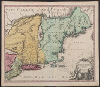
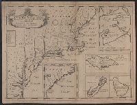
- Published / Created:
- 1755]
- Call Number:
- 755 1755A
- Container / Volume:
- BRBL_00690
- Image Count:
- 1
- Resource Type:
- Maps, Atlases & Globes
- Description:
- Shows New England, Maritime Provinces
- Subject (Geographic):
- New England--Maps--Early works to 1800
- Found in:
- Beinecke Rare Book and Manuscript Library > A map of the British & French Plantations in North America.
- Creator:
- Bellin, Jacques Nicolas, 1703-1772
- Published / Created:
- 1757
- Call Number:
- BrSides 2018 139
- Image Count:
- 1
- Resource Type:
- Maps, Atlases & Globes
- Subject (Geographic):
- New England--Maps--Early works to 1800.
- Found in:
- Beinecke Rare Book and Manuscript Library > Carte de la Nouvelle Angleterre, Nouvelle Yorck, et Pensilvanie / pour servir à l'Histoire générale des voyages. Par M.B., ing. de la mare.
- Creator:
- Homann Erben (Firm)
- Published / Created:
- 1777
- Call Number:
- 755 1777B
- Container / Volume:
- BRBL_00431
- Image Count:
- 1
- Resource Type:
- Maps, Atlases & Globes
- Found in:
- Beinecke Rare Book and Manuscript Library > America Septentrionalis a Domino d'Anville in Galliis edita nunc in Anglia : coloniis in interiorem Virginiam deductis nec non Fluvii Ohio cursu aucta notisque geographicis et historicis illustrata et ad bellum praesentis temporis accomodata / sumptibus Homannianorum Heredum.
- Creator:
- Homann Erben (Firm)
- Published / Created:
- 1756
- Call Number:
- 71 1756H
- Container / Volume:
- BRBL_00726
- Image Count:
- 1
- Resource Type:
- Maps, Atlases & Globes
- Found in:
- Beinecke Rare Book and Manuscript Library > America Septentrionalis a Domino d'Anville in Galliis edita nunc in Anglia : coloniis in interiorem Virginiam deductis nec non Fluvii Ohio cursu aucta notisque geographicis et historicis illustrata / sumptibus Homannianorum Heredum.
- Creator:
- Homann Erben (Firm), cartographer, publisher.
- Published / Created:
- 1756
- Call Number:
- 755 1756Ea
- Image Count:
- 1
- Resource Type:
- Maps, Atlases & Globes
- Found in:
- Beinecke Rare Book and Manuscript Library > America Septentrionalis a Domino d'Anville in Galliis edita nunc in Anglia : coloniis in interiorem Virginiam deductis nec non Fluvii Ohio cursu aucta notisque geographicis et historicis illustrata / sumptibus Homannianorum Heredum.
- Creator:
- Homann Erben (Firm)
- Published / Created:
- 1756
- Call Number:
- 755 1756B
- Container / Volume:
- BRBL_00428
- Image Count:
- 1
- Resource Type:
- Maps, Atlases & Globes
- Found in:
- Beinecke Rare Book and Manuscript Library > America Septentrionalis a Domino d'Anville in Galliis edita nunc in Anglia : coloniis in interiorem Virginiam deductis nec non Fluvii Ohio cursu aucta notisque geographicis et historicis illustrata / sumptibus Homannianorum Heredum.
- Creator:
- Homann Erben (Firm)
- Published / Created:
- 1756
- Call Number:
- 755 1756Ea
- Container / Volume:
- BRBL_00428
- Image Count:
- 1
- Resource Type:
- Maps, Atlases & Globes
- Found in:
- Beinecke Rare Book and Manuscript Library > America Septentrionalis a Domino d'Anville in Galliis edita nunc in Anglia : coloniis in interiorem Virginiam deductis nec non Fluvii Ohio cursu aucta notisque geographicis et historicis illustrata / sumptibus Homannianorum Heredum.
- Creator:
- Güssefeld, F. L. (Franz Ludwig), 1744-1807
- Published / Created:
- ao. 1784.
- Call Number:
- 755 1784A
- Container / Volume:
- BRBL_00435
- Image Count:
- 1
- Resource Type:
- Maps, Atlases & Globes
- Found in:
- Beinecke Rare Book and Manuscript Library > Charte über die XIII vereinigte Staaten von Nord-Amerika / entworfen durch F.L. Güssefeld und herausgegeben von den Homaennischen Erben.
- Creator:
- Homann Erben (Firm)
- Published / Created:
- 1756
- Call Number:
- 755 1756G
- Container / Volume:
- BRBL_00690
- Image Count:
- 1
- Resource Type:
- Maps, Atlases & Globes
- Found in:
- Beinecke Rare Book and Manuscript Library > America Septentrionalis a Domino d'Anville in Galliis edita nunc in Anglia : coloniis in interiorem Virginiam deductis nec non Fluvii Ohio cursu aucta notisque geographicis et historicis illustrata / sumptibus Homannianorum Heredum.
- Creator:
- Homann Erben (Firm)
- Published / Created:
- 1777
- Call Number:
- 71 1777H
- Container / Volume:
- BRBL_00726
- Image Count:
- 1
- Resource Type:
- Maps, Atlases & Globes
- Found in:
- Beinecke Rare Book and Manuscript Library > America Septentrionalis a Domino d'Anville in Galliis edita nunc in Anglia : coloniis in interiorem Virginiam deductis nec non Fluvii Ohio cursu aucta notisque geographicis et historicis illustrata et ad bellum praesentis temporis accomodata / sumptibus H
- Creator:
- Güssefeld, F. L. (Franz Ludwig), 1744-1807
- Published / Created:
- ao. 1784.
- Call Number:
- 75 1784G
- Container / Volume:
- BRBL_00727
- Image Count:
- 1
- Resource Type:
- Maps, Atlases & Globes
- Found in:
- Beinecke Rare Book and Manuscript Library > Charte über die XIII vereinigte Staaten von Nord-Amerika / entworfen durch F.L. Güssefeld und herausgegeben von den Homaennischen Erben.
- Published / Created:
- 1767
- Call Number:
- Lxi8 N4 1
- Collection Title:
- The New-England primer improved : For the more easy attaining the true reading of English. : To
- Image Count:
- 1
- Resource Type:
- Books, Journals & Pamphlets
- Alternative Title:
- New England primer
- Found in:
- Beinecke Rare Book and Manuscript Library > [Page with letters J through M in alphabet primer with rhyming verses].
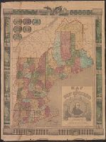
- Creator:
- Williams, Alexander
- Published / Created:
- 1852
- Call Number:
- 76GM 1852
- Container / Volume:
- BRBL_00446
- Image Count:
- 1
- Resource Type:
- Maps, Atlases & Globes
- Alternative Title:
- Telegraph and rail road map of the New
- Subject (Geographic):
- New England--Maps
- Subject (Topic):
- Railroads--New England--Maps
- Found in:
- Beinecke Rare Book and Manuscript Library > Williams' telegraph and rail road map of the New England states : Eastern portion of New York state and Canada/ compiled from the most authentic sources by Alexander Williams.
- Creator:
- From the Collection: Yale University. Office of Public Affairs
- Published / Created:
- 1865-1961
- Call Number:
- RU 690
- Container / Volume:
- Box 24, folder 397
- Image Count:
- 21
- Found in:
- Manuscripts and Archives > Yale events and activities photographs (RU 690) > Series I: Photographs of events and activities > Glee Club
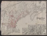
- Creator:
- Rand Avery Supply Co
- Published / Created:
- 1885
- Call Number:
- 753gme 1885
- Container / Volume:
- BRBL_00415
- Image Count:
- 2
- Resource Type:
- Maps, Atlases & Globes
- Description:
- Covers New England excluding Maine, and
- Subject (Topic):
- Railroads--New England--Maps
- Found in:
- Beinecke Rare Book and Manuscript Library > Map of the Boston & Lowell Railroad System : with its principal connections.
- Creator:
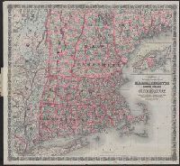
- G.W. & C.B. Colton & Co
- Published / Created:
- 1886
- Call Number:
- 76 1886
- Container / Volume:
- BRBL_00445
- Image Count:
- 1
- Resource Type:
- Maps, Atlases & Globes
- Subject (Geographic):
- New England--Maps
- Subject (Topic):
- Railroads--New England--Maps
- Found in:
- Beinecke Rare Book and Manuscript Library > Colton's railroad & township map of Massachusetts, Rhode Island and Connecticut : with parts of Maine, New Hampshire, Vermont & New York.
- Creator:
- Rand Avery Supply Co
- Published / Created:
- [1911?]
- Call Number:
- 76gme 1910
- Container / Volume:
- BRBL_00446A
- Image Count:
- 1
- Resource Type:
- Maps, Atlases & Globes
- Subject (Geographic):
- New England--Maps
- Subject (Topic):
- Railroads--New England--Maps
- Found in:
- Beinecke Rare Book and Manuscript Library > Boston & Maine Railroad and connections / Rand Avery Supply Co.
- Creator:
- Boston and Maine Railroad. General Passenger Dept
- Published / Created:
- [1900?]
- Call Number:
- 76gme 1900
- Container / Volume:
- BRBL_00446A
- Image Count:
- 2
- Resource Type:
- Maps, Atlases & Globes
- Subject (Geographic):
- New England--Maps
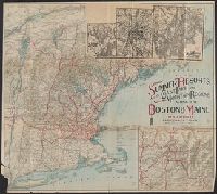
- Subject (Topic):
- Railroads--New England--Maps
- Found in:
- Beinecke Rare Book and Manuscript Library > Summer resorts of the coast, lake, and mountain regions along the Boston & Maine Railroad and connections.
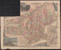
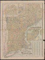
- Creator:
- Lossing & Barritt
- Published / Created:
- 1847
- Call Number:
- 76 1847
- Container / Volume:
- BRBL_00445
- Image Count:
- 1
- Resource Type:
- Maps, Atlases & Globes
- Description:
- of New England states in upper
- Subject (Geographic):
- New England--Maps
- Found in:
- Beinecke Rare Book and Manuscript Library > Map of New England / Lossing-Barritt, sc.