Skip to search
Skip to main content
Skip to first result
Search
You Searched For
Date
-
"Africa--Maps--Early works to 1800"
New Search
Search Results
Published / Created:
[1751]
Call Number:
BrSides Box 2019 32
Image Count:
1
Resource Type:
Maps, Atlases & Globes
Subject (Geographic):
--Early works to 1800 .
Subject (Topic):
Coasts--South Africa --Maps --Early works
Found in:
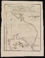
Beinecke Rare Book and Manuscript Library > Kort over Bayen St. Helena : udkaftet efter de Söfarendes Anmerkninger af N. Bellin.
Creator:
Published / Created:
1781
Call Number:
BrSides Folio 2017 19
Image Count:
1
Resource Type:
Maps, Atlases & Globes
Subject (Geographic):
Africa , West--Maps --Early works to 1800 .
Subject (Topic):
Coasts--Africa , West--Maps --Early works
Found in:
Beinecke Rare Book and Manuscript Library > Carta della bassa Guinea tra il capo tres puntas, e l'equatore / di Mr. d'Anville.
Creator:
Published / Created:
1670]
Call Number:
655 1670
Container / Volume:
BRBL_00345
Image Count:
1
Resource Type:
Maps, Atlases & Globes
Subject (Geographic):
Africa , West--Maps --Early works to 1800
Subject (Topic):
Coasts--Africa , West--Maps --Early works
Found in:
Beinecke Rare Book and Manuscript Library > Guinea.
Creator:
Published / Created:
1646 or 1647]
Call Number:
64 1646
Container / Volume:
BRBL_00338
Image Count:
1
Resource Type:
Maps, Atlases & Globes
Subject (Geographic):
Africa , Southern--Maps --Early works to
Subject (Topic):
Coasts--Africa , Eastern--Maps --Early
Found in:
Beinecke Rare Book and Manuscript Library > Carta seconda generale d'Affrica / AF: Lucini fece.
Published / Created:
[1751]
Call Number:
BrSides Box 2019 29
Image Count:
1
Resource Type:
Maps, Atlases & Globes
Subject (Geographic):
Table Bay (South Africa )--Maps --Early
Subject (Topic):
Coasts--South Africa --Maps --Early works
Found in:
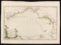
Beinecke Rare Book and Manuscript Library > Kort over Taffelbayen og Reden ved det Gode Haabs Forbierg efter adskillige Manuskripter udkastet af N. Bellin, Ing. de la Marine.
Creator:
Published / Created:
1766]
Call Number:
654 1766
Container / Volume:
BRBL_00344
Image Count:
1
Resource Type:
Maps, Atlases & Globes
Subject (Geographic):
Africa , West--Maps --Early works to 1800
Subject (Topic):
Coasts--Africa , West--Maps --Early works
Found in:
Beinecke Rare Book and Manuscript Library > A new and correct map of the coast of Africa, from Cape Blanco (lat. 20⁰40Ń) to the coast of Angola (lat. 11⁰S) : with explanatory notes of all the forts and settlements belonging to the several European powers / R.W. Seale, sculp.
Creator:
Published / Created:
1646-1647]
Call Number:
655 1646
Container / Volume:
BRBL_00345
Image Count:
1
Resource Type:
Maps, Atlases & Globes
Subject (Geographic):
Africa , West--Maps --Early works to 1800
Subject (Topic):
Coasts--Africa , West--Maps --Early works
Found in:
Beinecke Rare Book and Manuscript Library > Carta particolare che comincia con il fiume Iuntas nella Guinea è finisce con il capo di S. Dara è con l'Isola d'S:Tomaso / AF:Lucini fece.
Creator:
Published / Created:
1677
Call Number:
655 1677
Container / Volume:
BRBL_00345
Image Count:
1
Resource Type:
Maps, Atlases & Globes
Subject (Geographic):
Africa , West--Maps --Early works to 1800
Subject (Topic):
Coasts--Africa , West--Maps --Early works
Found in:
Beinecke Rare Book and Manuscript Library > Costes de Guińee avec les royaumes qui y sont connus des Européens, au dedans des terres : selon les relations les plus nouvelles / par P. Duval.
Creator:
Published / Created:
1596?]
Call Number:
63 1596
Container / Volume:
BRBL_00334
Image Count:
1
Resource Type:
Maps, Atlases & Globes
Subject (Geographic):
Africa , Eastern--Maps --Early works to
Subject (Topic):
Coasts--Africa , Eastern--Maps --Early
Found in:
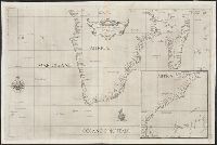
Beinecke Rare Book and Manuscript Library > Delineatio orarum maritimarum, terrae vulgo indigetatae terra do Natal item Sofalae, Mozambicae & Melindae ... [cartographic material] = Affbeeldinghe der custen des landts genaempt terra do Natal, item van alle de custen van Coffala, Mozambique, Melinde
Creator:
Published / Created:
1596?]
Call Number:
63 1596
Container / Volume:
BRBL_00334
Image Count:
1
Resource Type:
Maps, Atlases & Globes
Subject (Geographic):
Africa , Eastern--Maps --Early works to
Subject (Topic):
Coasts--Africa , Eastern--Maps --Early
Found in:
Beinecke Rare Book and Manuscript Library > Delineatio orarum maritimarum, terrae vulgo indigetatae terra do Natal item Sofalae, Mozambicae & Melindae ... [cartographic material] = Affbeeldinghe der custen des landts genaempt terra do Natal, item van alle de custen van Coffala, Mozambique, Melinde
Creator:
Published / Created:
1789 January 1
Call Number:
1982 Folio 10
Image Count:
1
Subject (Geographic):
Africa , West --Maps --Early works to
Subject (Topic):
Coasts --Africa , West --Maps --Early
Found in:
Beinecke Rare Book and Manuscript Library > The western coast of Africa, from Cape Blanco to Cape Virga, exhibiting Senegambia proper
Creator:
Published / Created:
1st January 1789.
Call Number:
655 1789
Container / Volume:
BRBL_00345
Image Count:
1
Resource Type:
Maps, Atlases & Globes
Subject (Geographic):
Africa , West--Maps --Early works to 1800
Subject (Topic):
Coasts--Africa , West--Maps --Early works
Found in:
Beinecke Rare Book and Manuscript Library > The western coast of Africa, from Cape Blanco to Cape Virga, exhibiting Senegambia proper / by T. Jefferys.
Creator:
Published / Created:
1596]
Call Number:
64 1596
Container / Volume:
BRBL_00337
Image Count:
1
Resource Type:
Maps, Atlases & Globes
Subject (Geographic):
Africa , Southern--Maps --Early works to
Subject (Topic):
Coasts--Africa , Southern--Maps --Early
Found in:
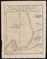
Beinecke Rare Book and Manuscript Library > Typus orarum maritimarum Guineae, Manicongo, & Angôlae ultra promontorium Bonae Spei ... [cartographic material] = Afheeldinghe der custen des landts Guinea, Manicongo, ende Angôla, ende voorts tot voorby de C. de boa esperança ... / Arnoldus F. á Lan
Creator:
Published / Created:
1596]
Call Number:
64 1596
Container / Volume:
BRBL_00337
Image Count:
1
Resource Type:
Maps, Atlases & Globes
Subject (Geographic):
Africa , Southern--Maps --Early works to
Subject (Topic):
Coasts--Africa , Southern--Maps --Early
Found in:
Beinecke Rare Book and Manuscript Library > Typus orarum maritimarum Guineae, Manicongo, & Angôlae ultra promontorium Bonae Spei ... [cartographic material] = Afheeldinghe der custen des landts Guinea, Manicongo, ende Angôla, ende voorts tot voorby de C. de boa esperança ... / Arnoldus F. á Lan
Creator:
Published / Created:
1720?]
Call Number:
49 1740
Container / Volume:
BRBL_00684
Image Count:
1
Resource Type:
Maps, Atlases & Globes
Subject (Topic):
--Maps --Early works to 1800
Found in:
Beinecke Rare Book and Manuscript Library > In notitiam ecclesiasticam Africae tabula geographica / auctore G. De L'Isle ...
Creator:
Published / Created:
1780
Call Number:
49 1780
Container / Volume:
BRBL_00267
Image Count:
1
Resource Type:
Maps, Atlases & Globes
Subject (Topic):
--Maps --Early works to 1800
Found in:
Beinecke Rare Book and Manuscript Library > In notitiam ecclesiasticam Africæ tabula geographica [cartographic material] / Auctore G. de l'Isle ; Joan. Bap. Liébaux inv. et sculp.
Published / Created:
1792
Call Number:
60cea 1792
Container / Volume:
BRBL_00329
Image Count:
1
Resource Type:
Maps, Atlases & Globes
Subject (Geographic):
Africa --Maps --Early works to 1800
Found in:
Beinecke Rare Book and Manuscript Library > A new Survey of the Coast of Africa from Senegal and Cape Verd to Cape St. Ann ...
Creator:
Published / Created:
1794?]
Call Number:
60 1794B
Container / Volume:
BRBL_00324
Image Count:
1
Resource Type:
Maps, Atlases & Globes
Subject (Geographic):
Africa --Maps --Early works to 1800
Found in:
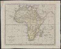
Beinecke Rare Book and Manuscript Library > A new and accurate map of Africa, drawn from the best authorities / by Thos. Bowen.
Published / Created:
1794
Call Number:
60cea 1794
Container / Volume:
BRBL_00329
Image Count:
1
Resource Type:
Maps, Atlases & Globes
Subject (Geographic):
Africa --Maps --Early works to 1800
Found in:
Beinecke Rare Book and Manuscript Library > A new chart of the Coast of Africa from the Straits of Gibralter to Cape Blanco with Madeira & the Canary Islands ...
Creator:
Published / Created:
1721]
Call Number:
60 1721
Container / Volume:
BRBL_00322
Image Count:
1
Resource Type:
Maps, Atlases & Globes
Subject (Geographic):
Africa --Maps --Early works to 1800
Found in:
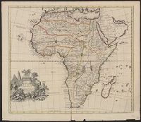
Beinecke Rare Book and Manuscript Library > A new map of Africa, from the latest observations.
Branch:v1.60.98 ,Deployed:2024-04-24T10:14:37-04:00