Search
You Searched For
Search Results
- Creator:
- Ordnance Survey of Great Britain and Ireland
Royal Geographical Society (Great Britain). Geographical Section
- Published / Created:
- 1918
- Call Number:
- 11hcf 1919E-6
- Container / Volume:
- BRBL_00010ZA
- Image Count:
- 1
- Resource Type:
- Maps, Atlases & Globes
- Subject (Geographic):
- Austria--Maps
- Found in:
- Beinecke Rare Book and Manuscript Library > (Vienna) Wien : North M 33. / compiled at the Royal Geographical Society under the direction of the Geographical Section ; drawn and printed by Ordnance Survey.
- Creator:
- Ordnance Survey of Great Britain and Ireland
Royal Geographical Society (Great Britain). Geographical Section
- Published / Created:
- 1915
- Call Number:
- 11hcf 1919E-5
- Container / Volume:
- BRBL_00010ZA
- Image Count:
- 1
- Resource Type:
- Maps, Atlases & Globes
- Subject (Geographic):
- Austria--Maps
- Found in:
- Beinecke Rare Book and Manuscript Library > (Vienna) Wien : North M 33. / compiled at the Royal Geographical Society under the direction of the Geographical Section ; drawn and printed by Ordnance Survey.
- Published / Created:
- 1811
- Call Number:
- 41 AU79 1811
- Container / Volume:
- BRBL_00242
- Image Count:
- 1
- Resource Type:
- Maps, Atlases & Globes
- Subject (Geographic):
- Austria--Maps
- Found in:
- Beinecke Rare Book and Manuscript Library > A new map of the circle of Austria ... / by John Cary, engraver.
- Published / Created:
- 1801
- Call Number:
- 41 AU79 1801
- Container / Volume:
- BRBL_00242
- Image Count:
- 1
- Resource Type:
- Maps, Atlases & Globes
- Subject (Geographic):
- Austria--Maps
- Found in:
- Beinecke Rare Book and Manuscript Library > A new map of the circle of Austria ... / by John Cary, engraver.
- Published / Created:
- 1811
- Call Number:
- 40 1811
- Container / Volume:
- BRBL_00199
- Image Count:
- 1
- Resource Type:
- Maps, Atlases & Globes
- Subject (Geographic):
- Tyrol (Austria)--Maps
- Found in:
- Beinecke Rare Book and Manuscript Library > A new map of the county of Tyrol, and the republic of Venice ... / by John Cary, engraver.
- Published / Created:
- 1799
- Call Number:
- 40 1799B
- Container / Volume:
- BRBL_00198
- Image Count:
- 1
- Resource Type:
- Maps, Atlases & Globes
- Subject (Geographic):
- Tyrol (Austria)--Maps--Early works to
- Found in:
- Beinecke Rare Book and Manuscript Library > A new map of the county of Tyrol, and the republic of Venice ... / by John Cary, engraver.
- Creator:
- Artaria & Co
- Published / Created:
- 1907
- Call Number:
- 11hcf 1919
- Image Count:
- 2
- Resource Type:
- Maps, Atlases & Globes
- Subject (Geographic):
- Austria--Maps
- Found in:
- Beinecke Rare Book and Manuscript Library > A.Steinhausers karte v. Mähren und Schlesien / bearbeitet v. Dr. K. Peucker.
- Creator:
- Homann, Johann Baptist, 1663-1724
- Published / Created:
- [ca. 1710]
- Call Number:
- 1983 Folio 23
- Collection Title:
- [Atlas factice of 50 maps, primarily by Johann Baptist Homann and/or issued by the Homann Erben
- Image Count:
- 1
- Subject (Geographic):
- Austria --Maps --Early works to 1800
- Found in:
- Beinecke Rare Book and Manuscript Library > Archiducatus Austriae [cartographic material] : inferioris in omnes suas quadrantes ditiones divisi nova et exacta tabula / e conatibus Io. Baptistae Homanni
- Creator:
- Seutter, Matthaeus, 1678-1756
- Published / Created:
- [after 1741]
- Call Number:
- BrSides Double Folio 2019 46
- Image Count:
- 1
- Resource Type:
- Maps, Atlases & Globes
- Subject (Geographic):
- Austria--Maps
- Found in:
- Beinecke Rare Book and Manuscript Library > Archiducatus Austriae inferioris accuratissima tabula : cujus ditiones in suos quadrant. / designatae edita opera et studio M. Seutt. Ch. Aug.
- Creator:
- Homann, Johann Baptist, 1663-1724
Vischer, Georg Matthaeus, 1628-1695
- Published / Created:
- [ca. 1710]
- Call Number:
- 1983 Folio 23
- Collection Title:
- [Atlas factice of 50 maps, primarily by Johann Baptist Homann and/or issued by the Homann Erben
- Image Count:
- 1
- Subject (Geographic):
- Austria --Maps --Early works to 1800
- Found in:
- Beinecke Rare Book and Manuscript Library > Archiducatus Austriae superioris in suas quadrantes ditiones exacte divisi accuratissima tabula [cartographic material] / ex amplissima Rev. Dn. Georg Matth. Vischer Sac. Caes. Mai. (Leopoldi Glor.mae Mem.) Geogra. ; desumta et exhibita a Ioh. Baptista Ho
- Creator:
- Artaria & Co., author.
- Published / Created:
- [between 1910 an 1919?]
- Call Number:
- 424 1910
- Container / Volume:
- BRBL_00245
- Image Count:
- 2
- Resource Type:
- Maps, Atlases & Globes
- Subject (Geographic):
- Austria--Maps.
- Found in:
- Beinecke Rare Book and Manuscript Library > Artaria's neueste Touristen-karten im Massstabe von 1:129,600.
- Published / Created:
- [1760?]
- Call Number:
- 428 1760
- Container / Volume:
- BRBL_00247
- Image Count:
- 5
- Resource Type:
- Maps, Atlases & Globes
- Subject (Geographic):
- Tyrol (Austria)--Maps--Early works to
- Found in:
- Beinecke Rare Book and Manuscript Library > Atlas Tyrolensis.
- Published / Created:
- 191-.
- Call Number:
- 11hcf 1919-42
- Container / Volume:
- BRBL_00010L
- Image Count:
- 1
- Resource Type:
- Maps, Atlases & Globes
- Subject (Geographic):
- Austria--Maps
- Found in:
- Beinecke Rare Book and Manuscript Library > Austria Hungary.
- Published / Created:
- 191-.
- Call Number:
- 11hcf 1919-41
- Container / Volume:
- BRBL_00010L
- Image Count:
- 1
- Resource Type:
- Maps, Atlases & Globes
- Subject (Geographic):
- Austria--Maps
- Found in:
- Beinecke Rare Book and Manuscript Library > Austria Hungary.
- Creator:
- United States. Office of Strategic Services. Research and Analysis Branch
- Published / Created:
- 1944
- Call Number:
- 42gmb 1944
- Container / Volume:
- BRBL_00245
- Image Count:
- 1
- Resource Type:
- Maps, Atlases & Globes
- Subject (Geographic):
- Austria--Maps
- Subject (Topic):
- Roads--Austria--Maps
- Found in:
- Beinecke Rare Book and Manuscript Library > Austria [cartographic material] : Federal roads 1937.
- Creator:
- Lazius, Wolfgang, 1514-1565
- Published / Created:
- [1641?]
- Call Number:
- 42 1640
- Container / Volume:
- BRBL_00244
- Image Count:
- 2
- Resource Type:
- Maps, Atlases & Globes
- Subject (Geographic):
- Austria--Maps--Early works to 1800
- Found in:
- Beinecke Rare Book and Manuscript Library > Austria archiducatus / [cartographic material] / auctore Wolfgango Lazio.
- Creator:
- Danckerts, Cornelis, ca. 1603-1656
Lazius, Wolfgang, 1514-1565
- Published / Created:
- [ca. 1631]
- Call Number:
- 1983 Folio 19
- Collection Title:
- [Atlas factice of 96 maps by Blaeu, Visscher, Jansson, Hondius and others]
- Image Count:
- 1
- Subject (Geographic):
- Austria --Maps --Early works to 1800
- Found in:
- Beinecke Rare Book and Manuscript Library > Austria archiducatus / auctore Wolfgango Lazio
- Creator:
- Lazius, Wolfgang, 1514-1565
- Published / Created:
- [1635]
- Call Number:
- 42 1630
- Container / Volume:
- BRBL_00244
- Image Count:
- 2
- Resource Type:
- Maps, Atlases & Globes
- Subject (Geographic):
- Austria--Maps--Early works to 1800
- Found in:
- Beinecke Rare Book and Manuscript Library > Austria archiducatus / auctore Wolfgango Lazio.
- Published / Created:
- 1627
- Call Number:
- 41 AU79 1627
- Container / Volume:
- BRBL_00242
- Image Count:
- 2
- Resource Type:
- Maps, Atlases & Globes
- Subject (Geographic):
- Austria--Maps--Early works to 1800
- Found in:
- Beinecke Rare Book and Manuscript Library > Austria archiducatus / per Gerardum Mercatorem ...
- Published / Created:
- [1912]
- Call Number:
- 41 1912
- Container / Volume:
- BRBL_00241
- Image Count:
- 1
- Resource Type:
- Maps, Atlases & Globes
- Subject (Geographic):
- Austria--Maps
- Found in:
- Beinecke Rare Book and Manuscript Library > Austria-Hungary / The London Geographical Institute.
- Published / Created:
- [191-?]
- Call Number:
- 11hcf 1919A-23
- Container / Volume:
- BRBL_00010M
- Image Count:
- 1
- Resource Type:
- Maps, Atlases & Globes
- Subject (Geographic):
- Austria--Maps
- Found in:
- Beinecke Rare Book and Manuscript Library > Austria-Hungary : Czecho-Slovak claims.
- Creator:
- Atkins, Paul M. (Paul Moody), 1892-
- Published / Created:
- 1910]
- Call Number:
- 41gc 1910
- Container / Volume:
- BRBL_00243
- Image Count:
- 1
- Resource Type:
- Maps, Atlases & Globes
- Subject (Geographic):
- Austria--Maps
- Found in:
- Beinecke Rare Book and Manuscript Library > Austria-Hungary : Population actively engaged in Agriculture Paul M. Atkins.
- Creator:
- Atkins, Paul M. (Paul Moody), 1892-
- Published / Created:
- 1910]
- Call Number:
- 41gf 1910
- Container / Volume:
- BRBL_00243
- Image Count:
- 1
- Resource Type:
- Maps, Atlases & Globes
- Subject (Geographic):
- Austria--Maps
- Found in:
- Beinecke Rare Book and Manuscript Library > Austria-Hungary : Population actively engaged in Industry Paul M. Atkins.
- Creator:
- American Geographical Society of New York
- Published / Created:
- [1914?]
- Call Number:
- 11hcf 1919B-13
- Container / Volume:
- BRBL_00010O
- Image Count:
- 3
- Resource Type:
- Maps, Atlases & Globes
- Subject (Geographic):
- Austria--Maps
- Found in:
- Beinecke Rare Book and Manuscript Library > Austria-Hungary [cartographic material].
- Published / Created:
- 1910?]
- Call Number:
- 41 1910A
- Container / Volume:
- BRBL_00241
- Image Count:
- 1
- Resource Type:
- Maps, Atlases & Globes
- Subject (Geographic):
- Austria--Maps
- Found in:
- Beinecke Rare Book and Manuscript Library > Austria-Hungary.
- Published / Created:
- 1919?].
- Call Number:
- 11hcf 1919C-3-14
- Container / Volume:
- BRBL_00010U
- Image Count:
- 1
- Resource Type:
- Maps, Atlases & Globes
- Subject (Geographic):
- Austria--Maps
- Found in:
- Beinecke Rare Book and Manuscript Library > Austria-Hungary.
- Published / Created:
- 1910?]
- Call Number:
- 11hcf 1919C-14
- Image Count:
- 1
- Resource Type:
- Maps, Atlases & Globes
- Subject (Geographic):
- Austria--Maps.
- Found in:
- Beinecke Rare Book and Manuscript Library > Austria-Hungary.
- Creator:
- Longmans, Green, and Co
- Published / Created:
- [191-?]
- Call Number:
- 11hcf 1919A-22
- Container / Volume:
- BRBL_00010M
- Image Count:
- 2
- Resource Type:
- Maps, Atlases & Globes
- Subject (Geographic):
- Austria--Maps
- Found in:
- Beinecke Rare Book and Manuscript Library > Austria-Hungary.
- Creator:
- Longmans, Green, and Co
- Published / Created:
- [191-?]
- Call Number:
- 11hcf 1919A-21
- Container / Volume:
- BRBL_00010M
- Image Count:
- 2
- Resource Type:
- Maps, Atlases & Globes
- Subject (Geographic):
- Austria--Maps
- Found in:
- Beinecke Rare Book and Manuscript Library > Austria-Hungary.
- Creator:
- Longmans, Green, and Co
- Published / Created:
- [191-?]
- Call Number:
- 11hcf 1919A-20
- Container / Volume:
- BRBL_00010M
- Image Count:
- 2
- Resource Type:
- Maps, Atlases & Globes
- Subject (Geographic):
- Austria--Maps
- Found in:
- Beinecke Rare Book and Manuscript Library > Austria-Hungary.
- Creator:
- Longmans, Green, and Co
- Published / Created:
- [191-?]
- Call Number:
- 11hcf 1919A-19
- Container / Volume:
- BRBL_00010M
- Image Count:
- 2
- Resource Type:
- Maps, Atlases & Globes
- Subject (Geographic):
- Austria--Maps
- Found in:
- Beinecke Rare Book and Manuscript Library > Austria-Hungary.
- Creator:
- Longmans, Green, and Co
- Published / Created:
- [191-?]
- Call Number:
- 11hcf 1919A-18
- Container / Volume:
- BRBL_00010M
- Image Count:
- 2
- Resource Type:
- Maps, Atlases & Globes
- Subject (Geographic):
- Austria--Maps
- Found in:
- Beinecke Rare Book and Manuscript Library > Austria-Hungary.
- Published / Created:
- 1944
- Call Number:
- 42 V67 1944
- Container / Volume:
- BRBL_00245
- Image Count:
- 1
- Resource Type:
- Maps, Atlases & Globes
- Subject (Geographic):
- Vienna (Austria)--Maps
- Found in:
- Beinecke Rare Book and Manuscript Library > Austria: Wien (Vienna). G.S.G.S. 4483 [cartographic material].
- Creator:
- United States. Office of Strategic Services. Research and Analysis Branch
- Published / Created:
- 1945
- Call Number:
- 42gm 1945
- Container / Volume:
- BRBL_00245
- Image Count:
- 1
- Resource Type:
- Maps, Atlases & Globes
- Subject (Geographic):
- Austria--Maps
- Subject (Topic):
- Telecommunication--Austria--Maps
- Found in:
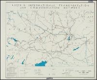
- Beinecke Rare Book and Manuscript Library > Austria: international transportation and communication network [cartographic material] / R & A, OSS.
- Creator:
- Visscher, Nicolaes, 1649-1702, cartographer
- Published / Created:
- [ca. 1700?]
- Call Number:
- 41 AU79 1700
- Container / Volume:
- BRBL_00242
- Image Count:
- 1
- Resource Type:
- Maps, Atlases & Globes
- Subject (Geographic):
- Austria--Maps--Early works to 1800
- Found in:
- Beinecke Rare Book and Manuscript Library > Austriae archiducatus pars superior in omnes ejusdem quadrantes ditiones accuratissime et distincte delineata [cartographic material] / per Nic. Visscher.
- Published / Created:
- 1832
- Call Number:
- 41 1832
- Container / Volume:
- BRBL_00241
- Image Count:
- 1
- Resource Type:
- Maps, Atlases & Globes
- Subject (Geographic):
- Austria--Maps
- Found in:
- Beinecke Rare Book and Manuscript Library > Austrian Empire / by J. Arrowsmith.
- Published / Created:
- 1816
- Call Number:
- 41 1816
- Container / Volume:
- BRBL_00241
- Image Count:
- 1
- Resource Type:
- Maps, Atlases & Globes
- Subject (Geographic):
- Austria--Maps
- Found in:
- Beinecke Rare Book and Manuscript Library > Austrian dominions / Neele, sculp.
- Published / Created:
- [1575?]
- Call Number:
- 41 1575
- Container / Volume:
- BRBL_00240
- Image Count:
- 1
- Resource Type:
- Maps, Atlases & Globes
- Subject (Geographic):
- Austria--Maps--Early works to 1800
- Found in:
- Beinecke Rare Book and Manuscript Library > Austriæ ducatus seu Pannoniæ superioris chorographia ... / a Wolfgango Lazio.
- Published / Created:
- Undated
- Call Number:
- 1983 Folio 19
- Collection Title:
- [Atlas factice of 96 maps by Blaeu, Visscher, Jansson, Hondius and others]
- Image Count:
- 2
- Subject (Geographic):
- Austria --Maps --Early works to 1800
- Found in:
- Beinecke Rare Book and Manuscript Library > Bohemia
- Published / Created:
- 1905]
- Call Number:
- 42 V67 1905
- Container / Volume:
- BRBL_00245
- Image Count:
- 1
- Resource Type:
- Maps, Atlases & Globes
- Subject (Geographic):
- Vienna (Austria)--Maps
- Found in:
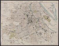
- Beinecke Rare Book and Manuscript Library > Bradshaw's Continental Railway Guide : Plan of Vienna.
- Published / Created:
- [1910?]
- Call Number:
- 428 K14 1910
- Container / Volume:
- BRBL_00248
- Image Count:
- 2
- Resource Type:
- Maps, Atlases & Globes
- Subject (Geographic):
- Karwendelgebirge (Austria)--Maps
- Found in:
- Beinecke Rare Book and Manuscript Library > Brunn's Spezialkarte vom Karwendelgebirge mit weiterer Umgebung / Bearbeitet v. Oscar Brunn
- Published / Created:
- [1680?]
- Call Number:
- 41 1680
- Container / Volume:
- BRBL_00241
- Image Count:
- 2
- Resource Type:
- Maps, Atlases & Globes
- Subject (Geographic):
- Austria--Maps--Early works to 1800
- Found in:
- Beinecke Rare Book and Manuscript Library > Carinthiae ducatus, et Goritiae palatinatus / Wolf. Lazio auctore.
- Published / Created:
- 1878
- Call Number:
- 11hcf 1919-40
- Container / Volume:
- BRBL_00010L
- Image Count:
- 1
- Resource Type:
- Maps, Atlases & Globes
- Subject (Geographic):
- Austria--Maps
- Found in:
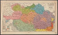
- Beinecke Rare Book and Manuscript Library > Carte ethnographique de l'Autriche-Hongrie et des régions habitées par les Roumains / aprés H. Kiepert. Epoque du Congrés de Berlin, 1878.
- Published / Created:
- [1910]
- Call Number:
- 36gmb 1910A
- Container / Volume:
- BRBL_00130
- Image Count:
- 1
- Resource Type:
- Maps, Atlases & Globes
- Subject (Geographic):
- Austria--Maps
- Found in:
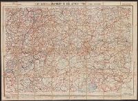
- Beinecke Rare Book and Manuscript Library > Carte routière de l'Allemagne du Sud, Autriche, Tyrol (Grands itinéraires).
- Published / Created:
- 1835
- Call Number:
- 427 K66 1835
- Container / Volume:
- BRBL_00246
- Image Count:
- 1
- Resource Type:
- Maps, Atlases & Globes
- Subject (Geographic):
- Carinthia (Austria)--Maps
- Found in:
- Beinecke Rare Book and Manuscript Library > Carte vom Kreise Klagenfurth im Herzogthume Kaernthen ... / in Stein gravirt von Friedrich Rivier.
- Creator:
- Danckerts, Justus, 1635-1701.
- Published / Created:
- after 1696]
- Call Number:
- 1973 Folio 18
- Image Count:
- 1
- Resource Type:
- Maps, Atlases & Globes
- Subject (Geographic):
- Austria--Maps--Early works to 1800.
- Found in:
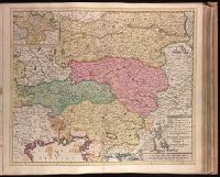
- Beinecke Rare Book and Manuscript Library > Circuli Austriaci in quo sunt archiducatus Austriae ducatus Stiriae Carintiae Carniolae Comitatus Tirolis et episcopatus Tridentini novissima deschriptio [cartographic material] / per Iustinum Danckerts.
- Creator:
- Jansson, Jan, 1588-1664
- Published / Created:
- [ca. 1680]
- Call Number:
- 1983 Folio 19
- Collection Title:
- [Atlas factice of 96 maps by Blaeu, Visscher, Jansson, Hondius and others]
- Image Count:
- 1
- Subject (Geographic):
- Tyrol (Austria) --Maps --Early works to
- Found in:
- Beinecke Rare Book and Manuscript Library > Comitatus Tirolensis
- Creator:
- Homann, Johann Baptist, 1663-1724
- Published / Created:
- [after 1724]
- Call Number:
- 1983 Folio 23
- Collection Title:
- [Atlas factice of 50 maps, primarily by Johann Baptist Homann and/or issued by the Homann Erben
- Image Count:
- 1
- Subject (Geographic):
- Tyrol (Austria)--Maps--Early works to
- Found in:
- Beinecke Rare Book and Manuscript Library > Comitatus principalis Tirolis : in quo Episc. Tridentin[us] et Brixensis, Comitatus Brigantinus, Feldkirchiae Sonnebergae et Pludentii accuratè exhibentur / editore Ioh. Baptista Homanno, Sacrae Caes. Majestatis Geographo.