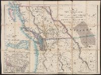
Cut and mounted on linen; "Wyld's new maps" advertisement on verso., Forts; boundaries; Indians; proposed railway; gold; coal., and Insets: Strait of San Juan de Fuca. -- on an enlarged scale. -- 7.4 x 8 cm.; British possessions in North America. -- scale [1:34
Publisher:
James Wyld,
Subject (Geographic):
British Columbia--Maps and Canada--Boundaries--United States--Maps
Subject (Topic):
Coal mines and mining--North America, Western--Maps, Gold mines and mining--British Columbia--Maps, and Indians--North America, Western--Maps
"Entered according to act of Congress in the year 1858 by A. Williams ....", Includes inset of "Line of coast from Panama to Frazer's Riv.", and Relief shown by hachures and spot heights.
Publisher:
A. Williams & Co.,
Subject (Geographic):
Fraser River (B.C.)--Gold discoveries--Maps and Washington (State)--Gold discoveries--Maps
Subject (Name):
A. Williams & Co and L.H. Bradford & Co
Subject (Topic):
Gold mines and mining--British Columbia--Fraser River--Maps