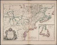
Although the map bears the date of 1755, it was not published until 1769., Dutch edition of Palairet's Carte des possessions angloises & francoises ... [1755]., From Isaak Tirion, and Hand col. Sheet measures 44 x 54 cm. Accompanied by ms. note by Henry Stevens.
Publisher:
By Isaak Tirion,
Subject (Geographic):
North America--Maps--Earlyworksto
Subject (Name):
Palairet, Jean, 1697-1774. Carte des possessions angloises & francoises du continent de l'Amerique Septentrionale
755 1755Z: Hand col. Sheet measures 44 x 54 cm., Although the map bears the date of 1755, it was not published until 1769., Dutch edition of Palairet's Carte des possessions angl, and Hand col. Sheet measures 44 x 54 cm. Accompanied by ms. note by Henry Stevens.
Publisher:
By Isaak Tirion,
Subject (Geographic):
North America--Maps--Earlyworksto
Subject (Name):
Palairet, Jean, 1697-1774. Carte des possessions angloises & francoises du continent de l'Amerique Septentrionale
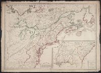
1st state. Distinguishing feature of 1st state: "Area south of Lake Erie shows Ohio River running east to west, no forts" (Pedley 212)., Includes "Supplément pour l'isle de Terre-Neuve.", and Shows British colonies as far south as the present state of North Ca
Publisher:
chés l'Auteur,
Subject (Geographic):
Canada--Maps--Early works to 1800, New France--Maps--Early works to 1800, Newfoundland and Labrador--Maps--Early works to 1800, and United States--Maps--Early works to 1800
Subject (Name):
Argenson, Marc-Pierre de Voyer, comte d', 1696-1764. dedication
Chart of the West-Indies or the islands of America in the North Sea
Description:
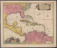
"P. 734, v. 11.", Covers North and South American coastline from Albemarle Sound to the mouth of the Orinoco R., and Includes text and inset of "La Veracruz."
Publisher:
s.n., 1745?]
Subject (Geographic):
Caribbean Area--Maps--Early works to 1800 and West Indies--Maps--Early works to 1800
"Cum Privilegio Ordinum Hollandiae et Westfrisiae.", Appears in Visscher's Atlas minor., Includes scales in milliaria germanica, hispanica, and gallica., Mounted on linen. Sheet measures 51.5 x 61.8 cm. Cross Collection no. 238., Relief shown pictorially., and Shows the West Indies and Central America from Florida to the northern part of South America, including boundaries, settlements and rivers.
Publisher:
Nunc apud Petrum Schenk Junior,
Subject (Geographic):
Caribbean Area--Maps--Early works to 1800, Mexico, Gulf of--Maps--Early works to 1800, and West Indies--Maps--Early works to 1800
Subject (Name):
Schenk, Pieter, ca. 1698-1775 and Visscher, Nicolaes, 1649-1702. Atlas minor