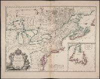
Although the map bears the date of 1755, it was not published until 1769., Dutch edition of Palairet's Carte des possessions angloises & francoises ... [1755]., From Isaak Tirion, and Hand col. Sheet measures 44 x 54 cm. Accompanied by ms. note by Henry Stevens.
Publisher:
By Isaak Tirion,
Subject (Geographic):
North America--Maps--Earlyworksto
Subject (Name):
Palairet, Jean, 1697-1774. Carte des possessions angloises & francoises du continent de l'Amerique Septentrionale
755 1755Z: Hand col. Sheet measures 44 x 54 cm., Although the map bears the date of 1755, it was not published until 1769., Dutch edition of Palairet's Carte des possessions angl, and Hand col. Sheet measures 44 x 54 cm. Accompanied by ms. note by Henry Stevens.
Publisher:
By Isaak Tirion,
Subject (Geographic):
North America--Maps--Earlyworksto
Subject (Name):
Palairet, Jean, 1697-1774. Carte des possessions angloises & francoises du continent de l'Amerique Septentrionale
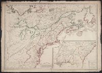
1st state. Distinguishing feature of 1st state: "Area south of Lake Erie shows Ohio River running east to west, no forts" (Pedley 212)., Includes "Supplément pour l'isle de Terre-Neuve.", and Shows British colonies as far south as the present state of North Ca
Publisher:
chés l'Auteur,
Subject (Geographic):
Canada--Maps--Early works to 1800, New France--Maps--Early works to 1800, Newfoundland and Labrador--Maps--Early works to 1800, and United States--Maps--Early works to 1800
Subject (Name):
Argenson, Marc-Pierre de Voyer, comte d', 1696-1764. dedication
Chart of the West-Indies or the islands of America in the North Sea
Description:
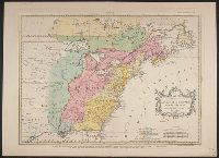
"P. 734, v. 11.", Covers North and South American coastline from Albemarle Sound to the mouth of the Orinoco R., and Includes text and inset of "La Veracruz."
Publisher:
s.n., 1745?]
Subject (Geographic):
Caribbean Area--Maps--Early works to 1800 and West Indies--Maps--Early works to 1800
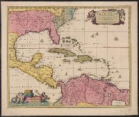
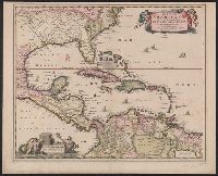
"Cum Privilegio Ordinum Hollandiae et Westfrisiae.", Appears in Visscher's Atlas minor., Includes scales in milliaria germanica, hispanica, and gallica., Mounted on linen. Sheet measures 51.5 x 61.8 cm. Cross Collection no. 238., Relief shown pictorially., and Shows the West Indies and Central America from Florida to the northern part of South America, including boundaries, settlements and rivers.
Publisher:
Nunc apud Petrum Schenk Junior,
Subject (Geographic):
Caribbean Area--Maps--Early works to 1800, Mexico, Gulf of--Maps--Early works to 1800, and West Indies--Maps--Early works to 1800
Subject (Name):
Schenk, Pieter, ca. 1698-1775 and Visscher, Nicolaes, 1649-1702. Atlas minor
"Cum Privilegio Ordinum Hollandiae et Westfrisiae.", Appears in Visscher's Atlas minor., In, Relief shown pictorially., and Shows the West Indies and Central America from Florida to the northern part of South America, including boundaries, settlements and rivers.
Publisher:
Nicolaes Visscher,
Subject (Geographic):
Caribbean Area--Maps--Early works to 1800, Mexico, Gulf of--Maps--Early works to 1800, and West Indies--Maps--Early works to 1800