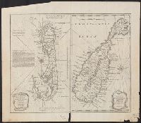
Inset: An accurate map of the Islands of St. Christopher, vulgarly called St. Kits., containing all the towns, parishes, forts, etc., by Emman. Brown. ca. 1:110,000. and Preliminary record.
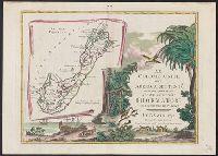
Colonie unite dell' America settentrle. di nuova projezione and Le isole Bermude [cartographic material].
Description:
"Con privilegio dell' eccellentissimo senato.", According to Ristow, the complete set of this 12 sheet map is sometimes bound separately with 3 other maps of Nor, Also appears in Zatta's Atlante novissimo., and Inset map: Le isole Bermude. Scale [ca. 1:145 000].
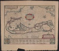
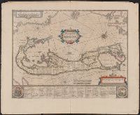
Insulae vel Insularum quas Bermudes vocant, descriptio, Insularum Bermudes, and Mappa Aestivarvm Insularum
Description:
At bottom of map "Nomina fortunae bona Submittentium in quaestus Virginiani alea A.⁰ 1622 ...", Cross Collection no. 65., From Jansonius's and Hondius's Atlas novus ... Amstelodami : Apud Ionnem Ianssonium & Henricum Hondium, 1638., and Signature 4Q on verso.
Publisher:
Apud Henricum Hondium,
Subject (Geographic):
BermudaIslands--Maps--Earlyworksto
Subject (Name):
Hondius, Hendrik, 1597-1651. Atlas novus and Jansson, Jan, 1588-1664. Atlas novus
Hand colored cooper engraving showing land divisions of island with list of owners below map. Chart showing relation of Bermuda to Atlantic coast forms background. Listed by Phillips as no. [83] in v. 3 Jansson, Jan, Nieuwen atlas ... des gheheelen aerdtb
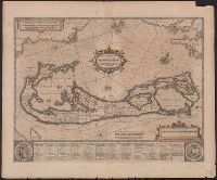
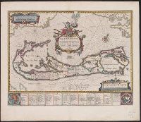
Mappa Aestivarvm insularum, alias Barmvdas dictarum
Description:
Below map, list of proprietors in 12 columns flanked by coats-of-arms., Borders are hand colored., and Not hand colored. With watermark. Sheet measures 46 x 55 cm.
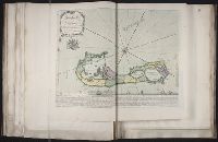
Mappa Aestivarvm insularum, alias Barmvdas dictarum
Description:
Based on Speed's map of 1626 but with new decorations., Below map, list of proprietors in 12 columns with arms of England and Bermuda., From the author's Theatre du monde ou nouvel atlas., Latin and English text on recto and French text on verso., Signature on verso: G., and Title on verso: L'Isle de Barmudas, avec ses voysines.
Publisher:
[Guillaume et Iean Blaeu,
Subject (Geographic):
BermudaIslands--Maps--Earlyworksto
Subject (Name):
Blaeu, Joan, 1596-1673. Theatrum orbis terrarum. French and Blaeu, Willem Janszoon, 1571-1638. Theatrum orbis terrarum. French
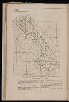
Lempriere, C., creator Toms, W. H. (William Henry), ca. 1700-ca. 1750
Published / Created:
1738?
Call Number:
2003 Folio 85
Image Count:
1
Description:
BEIN 2003 Folio 85: No. 33 of 45 maps bound together with binder's spine title: Atlas of America; ms. table of contents. Bookplate: Robinson. Bookplate of Paul Mellon., C. Lempriere delin., W.H. Thoms, sculp. Price 2s., Hand colored., is humbly dedicated by C. Lempriere and W.H. Thoms, 1738., Relief shown pictorially., and Scale [ca. 1:64,000].