Skip to search
Skip to main content
Skip to first result
Search
You Searched For
"British Columbia--Maps"
New Search
Search Results
Creator:
Published / Created:
1971
Call Number:
739 1971
Container / Volume:
BRBL_00389
Image Count:
2
Resource Type:
Maps, Atlases & Globes
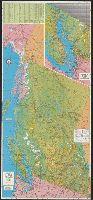
Alternative Title:
British Columbia
Description:
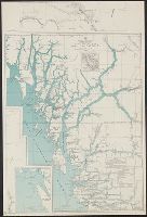
On recto: index and inset: Vancouver, Victoria and vicinity., On verso: text on points of interest, hunting and fishing information, and col. ill., Panel title., and Relief shown by shading and spot heights.
Publisher:
Grant-Mann Lithographers,
Subject (Geographic):
British Columbia --Maps
Subject (Name):
British Columbia. Dept. of Travel Industry and Grant-Mann Lithographers Limited
Subject (Topic):
Roads--British Columbia --Maps
Found in:
Beinecke Rare Book and Manuscript Library > Beautiful British Columbia [cartographic material] : 1971-1972 road map, campground & fishing guide / G.E. Brenner, cartographer.
Creator:
Published / Created:
1954
Call Number:
739 1954
Container / Volume:
BRBL_00389
Image Count:
2
Resource Type:
Maps, Atlases & Globes
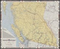
Alternative Title:
British Columbia, Canada, road map
Description:
Includes mileage chart., Relief shown by spot heights., and Text, ill., location map, and maps of "Vancouver and lower Fraser Valley" and "Northern British Columbia" on verso.
Publisher:
British Columbia Government Travel Bureau, Dept. of Trade and Industry,
Subject (Geographic):
British Columbia --Maps
Subject (Name):
British Columbia. Dept. of Lands and Forests and Geological Survey of Canada
Subject (Topic):
Roads--British Columbia --Maps
Found in:
Beinecke Rare Book and Manuscript Library > Highway and travel map of British Columbia / Basic map data by Geological Survey of Canada ; tourist information by Geographic Division, Surveys and Mapping Branch, Department of Lands and Forests.
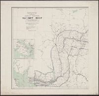
Creator:
Published / Created:
1908
Call Number:
739 1908
Container / Volume:
BRBL_00388
Image Count:
2
Resource Type:
Maps, Atlases & Globes
Description:
"Corrected to February 1st, 1908.", Indicates "lands disposed of, also timber berths.", Inset: Vancouver Island (Scale [ca. 1:1,267,200])., and Relief shown by spot heights.
Publisher:
The Department,
Subject (Geographic):
British Columbia --Maps
Subject (Name):
White, James, 1863-1928 and Young, R. E
Subject (Topic):
Railroads--British Columbia --Maps
Found in:
Beinecke Rare Book and Manuscript Library > British Columbia railway belt / Dept. of the Interior ; prepared under the direction of R.E. Young, Superintendent of Railway and Swamp Lands ; James White, F.R.G.S., geographer.
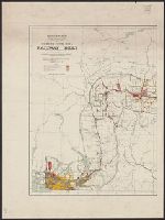
Creator:
Published / Created:
1907
Call Number:
739G 1907
Container / Volume:
BRBL_00392
Image Count:
2
Resource Type:
Maps, Atlases & Globes
Description:
"Corrected to July 1st, 1907.", Indicates "lands disposed of, also timber berths.", and Relief shown by spot heights.
Publisher:
The Department,
Subject (Geographic):
British Columbia --Maps
Subject (Name):
White, James, 1863-1928 and Young, R. E
Subject (Topic):
Railroads--British Columbia --Maps
Found in:
Beinecke Rare Book and Manuscript Library > British Columbia railway belt / Dept. of the Interior; prepared under the direction of R.E. Young, Superintendent of Railway and Swamp Lands; James White, F.R.G.S., geographer.
Creator:
Published / Created:
c1986.
Call Number:
739 1986
Container / Volume:
BRBL_00389
Image Count:
1
Resource Type:
Maps, Atlases & Globes
Description:
"This map is from British Columbia's coast (the Canadian inside passage), Alaska Geographic, volume 13, number 3, 1986 ..."
Publisher:
Alaska Geographic Society,
Subject (Geographic):
British Columbia --Maps
Subject (Topic):
Coasts--British Columbia --Maps
Found in:
Beinecke Rare Book and Manuscript Library > British Columbia's coast, the Canadian inside passage / cartographics by Steven Fisher.
Creator:
Published / Created:
1911
Call Number:
739 1911B
Container / Volume:
BRBL_00388
Image Count:
1
Resource Type:
Maps, Atlases & Globes
Description:
"The Colonist, Litho." and Relief by spot hts.; railway lines.
Publisher:
Dept. of Lands,
Subject (Geographic):
British Columbia --Maps
Subject (Topic):
Railroads--British Columbia --Maps
Found in:
Beinecke Rare Book and Manuscript Library > Map of the Province of British Columbia.
Creator:
Published / Created:
1939
Call Number:
739gmb 1939
Container / Volume:
BRBL_00393
Image Count:
2
Resource Type:
Maps, Atlases & Globes
Alternative Title:
Shell road map , British Columbia
Description:
"1939-1", "Above data in effect as of January 1, 1939", Also shows northern Washington, northern Idaho, and northwestern Montana., At head of title: Shell., Directory of radio stations in British Columbia, Alberta, and the western United States on verso., and Inde
Publisher:
H.M. Goushá Co.,
Subject (Geographic):
British Columbia --Maps
Subject (Name):
Shell Oil Company
Subject (Topic):
Roads--British Columbia --Maps
Found in:
Beinecke Rare Book and Manuscript Library > Official road map of British Columbia.
Creator:
Published / Created:
[1909]
Call Number:
739CBF B386 1909
Container / Volume:
BRBL_00391
Image Count:
1
Resource Type:
Maps, Atlases & Globes
Alternative Title:
Part of the railway belt, British Columbia
Description:
Accompanies: Annual report of the Topographical Surveys Branch, 1908-1909., Relief shown by hachures and spot heights., and Shows primary and secondary triangulations.
Publisher:
Topographical Surveys Branch,
Subject (Geographic):
British Columbia --Maps
Subject (Topic):
Triangulation--British Columbia --Maps
Found in:
Beinecke Rare Book and Manuscript Library > Sketch map of part of the railway belt, British Columbia : showing main topographical features in the districts drained by the Blaeberry River, Bush River, Gold Creek and their confluents. Also the Continental Divide northwest from Mt. Freshfield.
Creator:
Published / Created:
1862
Call Number:
739 F86 1862
Container / Volume:
BRBL_00389
Image Count:
1
Resource Type:
Maps, Atlases & Globes
Description:
"Entered according to the Act of Congress in the year 1862 by Gustavus Epner in the Clerks Office of the District Court of the North Dist. of California." and Inset: Routes of comunication with the Cariboo Mines. -- Tables showing mileages along Douglas & Ft.
Publisher:
Epner,
Subject (Geographic):
British Columbia--19th century--Maps
Subject (Name):
Britton & Co
Subject (Topic):
Distances--British Columbia --Maps
Found in:
Beinecke Rare Book and Manuscript Library > Map of the gold regions in British Columbia / [cartographic material] compiled from sketches and information by His Excellency James Douglas, C.B., Governor of British Columbia and Vancouver Island and from data obtained from the most intelligent and reli
Creator:
Published / Created:
1943
Call Number:
739 B41 1943
Container / Volume:
BRBL_00389
Image Count:
1
Resource Type:
Maps, Atlases & Globes
Description:
"AMS A521.", Inset: Index map., Marginal maps: [Extensions to east and west], Military grid., and Preliminary map.
Publisher:
Army Map Service, U.S. Army,
Subject (Geographic):
Bella Coola (B.C.)--Suburbs and environs--Maps
Subject (Topic):
Coasts--British Columbia --Maps
Found in:
Beinecke Rare Book and Manuscript Library > Bella Coola, 1924.
Branch:v1.61.6 ,Deployed:2024-06-12T09:55:33-04:00