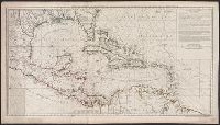
"4 e. feuille.", "No. 5" in lower right corner., Prime meridian: Paris., Relief shown pictorially. Depths shown by soundings., Shows English ownership of Florida., and Stamped no. "107" and title "Golfe du Mexique" on verso. Cross Collection no. 246.
Publisher:
Sur ley Quay de la Megisserie prés le Pont Neuf ...,
Subject (Geographic):
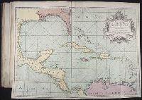
Caribbean Area--Maps--Early works to 1800
Subject (Name):
Buache, Philippe, 1700-1773. Atlas géographique et universel, L'Isle, Guillaume de, 1675-1726. Atlas géographique et universel, and Popple, Henry, -1743
Cruz Cano y Olmedilla, Juan de la, d. 1790 Lopez de Vargas Machuca, Tomas, 1731-1802, creator
Published / Created:
1755
Call Number:
2003 Folio 85
Image Count:
1
Description:
Available also through the Library of Congress Web site as a raster image., BEIN 2003 Folio 85: No. 27 of 45 maps bound together with binder's spine title: Atlas of America; ms. table of contents. Bookplate: Robinson. Bookplate of Paul Mellon., Dedicado a la Catholica Magestad de Don Fernando VI Rey de Espana, y de las Yndias, por sus mas rendidos, y fieles vasallos, Thomas Lopez, y Juan de la Cruz., Depths shown by soundings., Hand colored., LC Maps of North America, 1750-1789,, Longitud ocidental del meridiano de Tenerife., and Scale [ca. 1:5,500,000].
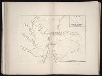
The West-India pilot: containing piloting directions for Port Royal and Kingston harbours in
Image Count:
1
Subject (Geographic):
Atlantic Ocean --Maps --Early works to 1800, Central America --Maps --Early works to 1800, Providence Island (Colombia) --Maps, and Santa Catalina Island (Colombia)
Subject (Topic):
Nauticalcharts --CaribbeanArea
Collection Created:
London : Printed for the author and sold by S. Hooper ..., MDCCLXXI [1771]
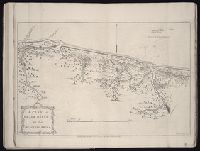
The West-India pilot: containing piloting directions for Port Royal and Kingston harbours in
Image Count:
1
Subject (Geographic):
Atlantic Ocean --Maps --Early works to 1800, Santo Domingo (Dominican Republic) --Maps --Early works to 1800, and West Indies --Maps --Early works to 1800
Subject (Topic):
Nauticalcharts --CaribbeanArea
Collection Created:
London : Printed for the author and sold by S. Hooper ..., MDCCLXXI [1771]
The West-India pilot: containing piloting directions for Port Royal and Kingston harbours in
Image Count:
1
Subject (Geographic):
Atlantic Ocean --Maps --Early works to 1800, Central America --Maps --Early works to 1800, and Mosquitia (Nicaragua and Honduras) --Maps --Early works to 1800
Subject (Topic):
Nauticalcharts --CaribbeanArea
Collection Created:
London : Printed for the author and sold by S. Hooper ..., MDCCLXXI [1771]