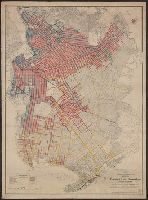
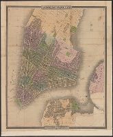
Asphalt, brick and iron slag, belgian block, medina sandstone, macadam, and wood blook pavements are shown., Identifies streets, blocks, paths, neighborhoods, parks, cemeteries, hotels, waterways, public buildings, and race tracks., and Pavement types identifie
Citizens and travelers guide map into and from the City of New York and adjacent places and Guide map of New York City
Description:
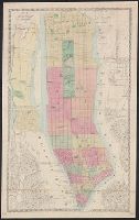
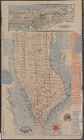
Imperfect: mutilated, with some loss of text., Includes tourist information and inset map, Oriented with north to the upper left., Shows docks, local transit and ferry lines and radial distances from city hall., and Shows Manhattan south of 63rd St.
Publisher:
C.W. Hobbs,
Subject (Geographic):
Bronx (NewYork, N.Y.)--Maps
Subject (Name):
Rand, Avery & Co
Subject (Topic):
Docks--New York (State)--Manhattan (N.Y.)--Maps and Local transit--New York (State)--Manhattan (N.Y.)--Maps
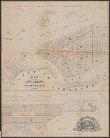
Engraved and printed by S. Stiles & Co. and Engraving tinted to show wards, squares, cemeteries, public buildings, the Navy yard, ect. Also shows ferry boat docks and distances of ferry travel.