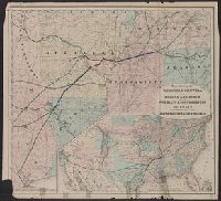
Map of the south-central states showing drainage, township and counties, cities and towns, and the railroad network with named lines and colored to emphasize main lines.
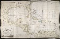
Imperfect: pages 13-16, 39-40, 45-48, 171-172, 187-188, and 267-268 wanting. and Inscribed "Jan. 28, 1876, New Orleans" at the top of page 65.
Subject (Geographic):
Nashville (Tenn.) --Fiction and New York (N.Y.) --Fiction
Subject (Topic):
Race relations --Fiction, Reconstruction (U.S. history, 1865-1877) --Fiction, Slavery --United States --Fiction, and Women’s rights --United States --History --19th century
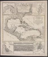
Carte de isles de l'Amérique, Delineatio munimenti et portus S. Augustini, Delineatio portus mexicani Vera Cruz, Technographia urbis San-Domingo, and Urbs capitalis regni mexicani dicta Mexico
Description:
Large central map shows southernUnited
Publisher:
Homann Heirs,
Subject (Geographic):
Caribbean Area--Maps--Early works to 1800, Central America--Maps--Early works to 1800, Haiti--Maps--Early works to 1800, Mexico City (Mexico)--Maps--, and Veracruz (Veracruz-Llave, Mexico)--Maps--Early works to 1800
Subject (Name):
Anville, Jean Baptiste Bourguignon d', 1697-1782. Carte des isles de l'Amérique and Homann Erben (Firm)
South Carolina Infantry, United States. Continental Army. Southern Department, United States. Continental Army--Finance, United States. Continental Army--History--Sources, and United States. Continental Army--Pay, allowances, etc