
You Searched For
1 - 9 of 9
Search Results
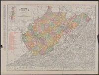
2.
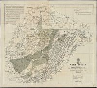
- Creator:
- Morris, R. L. (Russell L.)
- Published / Created:
- 1899
- Call Number:
- 784ca 1899
- Container / Volume:
- BRBL_00512
- Image Count:
- 1
- Resource Type:
- Maps, Atlases & Globes
- Description:
- Also covers part of Pennsylvania, Maryland, Kentucky, and Ohio., Below lower margin at left: A. Hoen & Co. Lith., Include text at upper left & right corners within map border., Includes chart of explanations., Relief shown by hachures., and Shows state and county
- Publisher:
- West Virginia Geological and Economic Survey?],
- Subject (Geographic):
- West Virginia--Maps
- Subject (Name):
- A. Hoen & Co, West Virginia Geological and Economic Survey, and White, I. C. (Israel Charles), 1848-1927
- Subject (Topic):
- Geology--West Virginia--Maps
- Found in:
- Beinecke Rare Book and Manuscript Library > A map of West Virginia / compiled by Russell L. Morris, C.E., from county atlases, government and other surveys, showing the coal, oil, and gas developments, prominent anticlinal axes, and the outcrops of the different coal series by I. C. White.
3.
- Creator:
- United States. Post Office Dept
- Published / Created:
- 1874
- Call Number:
- 754GMD 1874
- Container / Volume:
- BRBL_00419
- Image Count:
- 2
- Resource Type:
- Maps, Atlases & Globes
- Description:
- Imperfect: 2 sheets wanting.
- Publisher:
- Post Office Dept.,
- Subject (Geographic):
- West Virginia--Maps
- Subject (Name):
- Nicholson, W. L
- Subject (Topic):
- Postal service--West Virginia--Maps
- Found in:
- Beinecke Rare Book and Manuscript Library > Preliminary post route map of the states of Virginia and West Virginia together with Maryland and Delaware, with adjacent parts of Pennsylvania, Ohio, Kentucky, Tennessee and North Carolina / designed and constructed under the orders of Postmaster General
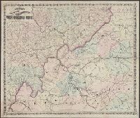
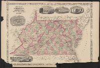
- Creator:
- Rand McNally and Company
- Published / Created:
- c1886.
- Call Number:
- 783 1886
- Container / Volume:
- BRBL_00509
- Image Count:
- 1
- Resource Type:
- Maps, Atlases & Globes
- Alternative Title:
- Rand McNally & Co.'s Virginia and West Virginia.
- Description:
- Relief shown by hachures.
- Publisher:
- Rand McNally,
- Subject (Geographic):
- West Virginia--Maps
- Found in:
- Beinecke Rare Book and Manuscript Library > Virginia and West Virginia.
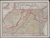
- Published / Created:
- 1911
- Call Number:
- 784 1911
- Container / Volume:
- BRBL_00512
- Image Count:
- 1
- Resource Type:
- Maps, Atlases & Globes
- Alternative Title:
- Rand McNally's new business atlas map of Virginia and West Virginia.
- Description:
- Inset map Northern portion of West Virginia, same scale. and Noted in red, list of West Virginia Railroads.
- Publisher:
- Rand McNally & Co. ,
- Subject (Geographic):
- West Virginia--Maps
- Found in:
- Beinecke Rare Book and Manuscript Library > West Virginia.
- Creator:
- Johnson, A. J. (Alvin Jewett), 1827-1884
- Published / Created:
- [between 1866 and 1879]
- Call Number:
- 783 1866A
- Container / Volume:
- BRBL_00509
- Image Count:
- 2
- Resource Type:
- Maps, Atlases & Globes
- Alternative Title:
- Virginia, Delaware, Maryland and West Virginia
- Description:
- "Entered according to Act of Congress in the Year 1864, by A.J. Johnson in the Clerks Office of the District Court of the United States for the Southern District of New York." and Includes illustrations or buildings: University of Virginia--Fortress Monroe--G
- Publisher:
- A.J. Johnson,
- Subject (Geographic):
- West Virginia--Maps
- Subject (Topic):
- Counties--West Virginia--Maps
- Found in:
- Beinecke Rare Book and Manuscript Library > Johnson's Virginia, Delaware, Maryland and West Virginia.
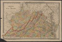
7.
- Creator:
- Nicholson, W. L
- Published / Created:
- 1863
- Call Number:
- 783 1863B
- Container / Volume:
- BRBL_00509
- Image Count:
- 1
- Resource Type:
- Maps, Atlases & Globes
- Description:
- Also covers Delaware, Maryland, West Virginia and parts of adjacent states., Includes table: Distances by railroads., and Relief shown by hachures.
- Publisher:
- The Office,
- Subject (Geographic):
- West Virginia--Maps
- Subject (Name):
- Bache, A. D. (Alexander Dallas), 1806-1867, Krebs, Charles G, and United States Coast Survey
- Found in:
- Beinecke Rare Book and Manuscript Library > Map of the state of Virginia / compiled from the best authorities and printed at the Coast Survey Office, A.D. Bache, supdt. ; compiled by W.L. Nicholson ; lith. by Chas. G. Krebs.
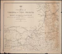
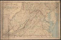
- Published / Created:
- [1890?].
- Call Number:
- 754 1890
- Container / Volume:
- BRBL_00417
- Image Count:
- 1
- Resource Type:
- Maps, Atlases & Globes
- Description:
- Inset: South west part of Virginia.
- Subject (Geographic):
- West Virginia--Maps
- Found in:
- Beinecke Rare Book and Manuscript Library > Railroad and county map of Virginia, W. Virginia, Maryland and Delaware.
9.
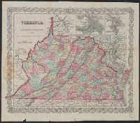
- Creator:
- Colton, J. H. (Joseph Hutchins), 1800-1893
- Published / Created:
- 1857
- Call Number:
- 783 1857
- Container / Volume:
- BRBL_00508
- Image Count:
- 1
- Resource Type:
- Maps, Atlases & Globes
- Description:
- "Entered according to Act of Congress in the year 1855 by J.H. Colton & Co. in the Clerks Office of the District Court for the Southern District of New York.", Explanations: Rail Roads, Common, Canals, State Capital, County Towns, Vill. P.O. & Depots., and Map
- Publisher:
- Published by J.H. Colton & Co. No. 172 William Street,
- Subject (Geographic):
- West Virginia--Maps--19th century
- Subject (Name):
- J.H. Colton & Co
- Found in:
- Beinecke Rare Book and Manuscript Library > Virginia.