Search
You Searched For
Search Results
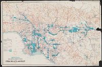
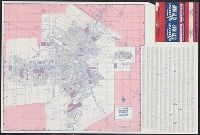
- Creator:
- Brewster Maps
- Published / Created:
- c1961.
- Call Number:
- 844 L89 1961
- Image Count:
- 1
- Description:
- Relief shown by shading and spot heights., "No. 6104.", and BEIN 844 L89 1961: Imperfect: Chipped with some loss of text.
- Publisher:
- Brewster Maps
- Subject (Geographic):
- California and Los Angeles Metropolitan Area
- Subject (Topic):
- Industrial sites and Roads
- Found in:
- Beinecke Rare Book and Manuscript Library > Industrial areas, freeways, and major streets of greater Los Angeles
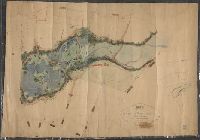
- Creator:
- Mitchell, Donald Grant, 1822-1908, cartographer
- Published / Created:
- Decr. 1863.
- Call Number:
- Roll Map 78
- Image Count:
- 2
- Resource Type:
- cartographic image
- Alternative Title:
- Map of a portion of Westville and New
- Description:
- . Manuscript note on verso (partially trimmed): Map
- Subject (Geographic):
- New Haven (Conn.)
- Found in:
- Beinecke Rare Book and Manuscript Library > Map of a portion of Westville & New Haven
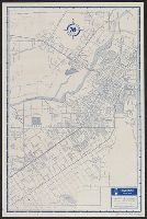
- Creator:
- Thomas Bros. Maps
- Published / Created:
- [1953?]
- Call Number:
- 844gmb R524 1953
- Container / Volume:
- BRBL_00617
- Image Count:
- 2
- Resource Type:
- Maps, Atlases & Globes
- Alternative Title:
- Riverside city map
- Description:
- Maps of "Recreational area surrounding
- Publisher:
- Thomas Bros.,
- Subject (Geographic):
- Riverside (Calif.)--Maps
- Subject (Name):
- Palomar Observatory--Maps
- Subject (Topic):
- --Riverside--Maps
- Found in:
- Beinecke Rare Book and Manuscript Library > Riverside street map / made by Thomas Bros.
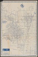
- Creator:
- Thomas Bros. Maps
- Published / Created:
- [1952?]
- Call Number:
- 844gmb P773 1952
- Container / Volume:
- BRBL_00617
- Image Count:
- 2
- Resource Type:
- Maps, Atlases & Globes
- Alternative Title:
- Pomona city map
- Description:
- , and map of "Downtown Pomona" on verso.
- Publisher:
- Thomas Bros. Maps,
- Subject (Geographic):
- Pomona (Calif.)--Maps
- Subject (Name):
- Union Oil Company of California
- Subject (Topic):
- --Pomona--Maps
- Found in:
- Beinecke Rare Book and Manuscript Library > Pomona and vicinity street map / made by Thomas Bros.
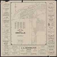
- Creator:
- Thomas Bros. Maps
- Call Number:
- 844 Or6 1928
- Container / Volume:
- BRBL_00607
- Image Count:
- 2
- Resource Type:
- Maps, Atlases & Globes
- Alternative Title:
- Map of Oroville, California
- Description:
- Map of "Butte County, California
- Publisher:
- Thomas Bros., [1928]
- Subject (Geographic):
- Butte County (Calif.)--Maps
- Subject (Topic):
- Streets--California--Oroville--Maps
- Found in:
- Beinecke Rare Book and Manuscript Library > Thomas Bros. map of Oroville / compiled and published by Thomas Bros. map specialties.
- Creator:
- Thomas Bros. Maps
- Published / Created:
- [1928]
- Call Number:
- 844 R524 1928
- Container / Volume:
- BRBL_00607
- Image Count:
- 2
- Resource Type:
- Maps, Atlases & Globes
- Alternative Title:
- Map of Riverside
- Description:
- "Southern California highway map
- Publisher:
- Thomas Bros.,
- Subject (Geographic):
- Riverside (Calif.)--Maps
- Subject (Name):
- Thomas, Geo. Coupland (George Coupland)
- Subject (Topic):
- Roads--California, Southern--Maps
- Found in:
- Beinecke Rare Book and Manuscript Library > 1928 map of Riverside / compiled & published by Thomas Bros.
- Creator:
- Thomas Bros. Maps
- Published / Created:
- [1952?]
- Call Number:
- 844gmb V243 1952
- Container / Volume:
- BRBL_00618
- Image Count:
- 2
- Resource Type:
- Maps, Atlases & Globes
- Alternative Title:
- Vallejo city map
- Description:
- Index, text, ill., and map of "Downtown
- Publisher:
- Thomas Bros.,
- Subject (Geographic):
- Vallejo (Calif.)--Maps
- Subject (Name):
- Thomas, Geo. Coupland (George Coupland)
- Subject (Topic):
- --Vallejo--Maps
- Found in:
- Beinecke Rare Book and Manuscript Library > Vallejo and vicinity street map / made by Thomas Bros.
- Creator:
- Thomas Bros. Maps
- Published / Created:
- [1953?]
- Call Number:
- 847gmb B75 1953
- Container / Volume:
- BRBL_00629
- Image Count:
- 2
- Resource Type:
- Maps, Atlases & Globes
- Alternative Title:
- Bremerton city map
- Description:
- Index, ill., advertisements, and map of
- Publisher:
- Thomas Bros.,
- Subject (Geographic):
- Bremerton (Wash.)--Maps
- Subject (Name):
- Union Oil Company of California
- Subject (Topic):
- (State)--Bremerton--Maps
- Found in:
- Beinecke Rare Book and Manuscript Library > Bremerton street map / made by Thomas Bros. [for] Union Oil Company.
- Creator:
- Thomas Bros. Maps
- Published / Created:
- [1960?]
- Call Number:
- 844gmb B455 1960
- Container / Volume:
- BRBL_00616
- Image Count:
- 2
- Resource Type:
- Maps, Atlases & Globes
- Alternative Title:
- Map of Berkeley, California
- Description:
- Copyright: Geo. Coupland Thomas., In lower left: 945., Indexed., Relief shown by hachures and spot heights., and Text, and ill. on verso.
- Publisher:
- Thomas Bros.,
- Subject (Geographic):
- Albany (Calif.)--Maps
- Subject (Name):
- Berkeley Chamber of Commerce and Thomas, Geo. Coupland (George Coupland)
- Subject (Topic):
- Metropolitan Area--Maps
- Found in:
- Beinecke Rare Book and Manuscript Library > Map of Berkeley, Albany, and vicinity, California / compiled and published by Thomas Bros. ; [for] Berkeley Chamber of Commerce, County of Alameda.
- Creator:
- Arrow Maps, inc
- Published / Created:
- [1973].
- Call Number:
- 736 W73 1973
- Container / Volume:
- BRBL_00382
- Image Count:
- 1
- Resource Type:
- Maps, Atlases & Globes
- Alternative Title:
- Arrow city map.
- Description:
- Includes street directory.
- Publisher:
- Arrow Maps, Inc.,
- Subject (Geographic):
- Winnipeg (Man.)--Maps
- Found in:
- Beinecke Rare Book and Manuscript Library > Official Arrow map of metropolitan Winnipeg, Manitoba.