- Creator:
- Valck, G. (Gerard), 1651 or 2-1726
- Published / Created:
- 169-?]
- Call Number:
- 70 1670
- Container / Volume:
- BRBL_00685
- Image Count:
- 1
- Resource Type:
- Maps, Atlases & Globes
- Description:
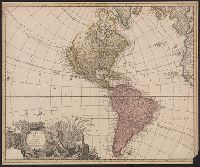
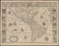
- Imperfect: mutilated at corner, with some loss of text. Sheet measures 50.7 x 61.1 cm. Mounted on card stock. Cross Collection no. 121., R, Shows California as an island., and Shows North and South America, Greenland, Iceland, western edges of Europe and Africa.
- Publisher:
- s.n.,
- Subject (Geographic):
- America--Maps--Early works to 1800
- Subject (Name):
- Valck, Leonard, 1675-1746
- Found in:
- Beinecke Rare Book and Manuscript Library > America aurea pars altera mundi / auctoribus Gerardo et Leonardo Valk.
You Searched For
« Previous
| 1 - 10 of 21 |
Next »
Search Results
- Creator:
- Valck, G. (Gerard), 1651 or 2-1726
- Published / Created:
- 169-?]
- Call Number:
- 70 1670A
- Container / Volume:
- BRBL_00354
- Image Count:
- 1
- Resource Type:
- Maps, Atlases & Globes
- Description:
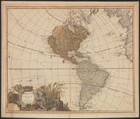
- "Cum privilegio ordinum Hollandiae et West Frisiae.", Relief shown pictorially., Sheet measures 53.5 x 63 cm., Shows California as an island., and Shows North and South America, Greenland, Iceland, western edges of Europe and Africa.
- Publisher:
- s.n.,
- Subject (Geographic):
- America--Maps--Early works to 1800
- Subject (Name):
- Valck, Leonard, 1675-1746
- Found in:
- Beinecke Rare Book and Manuscript Library > America aurea pars altera mundi / auctoribus Gerardo et Leonardo Valk.
- Creator:
- Hondius, Hendrik, 1597-1651
- Published / Created:
- between 1639 and 1644?]
- Call Number:
- 70 163X
- Container / Volume:
- BRBL_00353
- Image Count:
- 2
- Resource Type:
- Maps, Atlases & Globes
- Description:
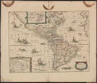
- Appears in various eds. of Jan Jansson's Nouvel atlas., French text on verso., Includes ill. of ships and sea monsters, and insets showing "Polus Arcticus" region and "Terra Australis inc, and Sheet measures 50 x 59 cm. Stamp on verso: Yale, Horace Brown, 1900S.
- Publisher:
- s.n.,
- Subject (Geographic):
- America--Maps--Early works to 1800
- Subject (Name):
- Jansson, Jan, 1588-1664. Nouvel atlas
- Found in:
- Beinecke Rare Book and Manuscript Library > America noviter delineata / auct. Henrico Hondio, 1631.
4.
- Creator:
- Mercator, Michael, d. 1600
- Published / Created:
- between 1613 and 1630]
- Call Number:
- 70 1595
- Container / Volume:
- BRBL_00685
- Image Count:
- 2
- Resource Type:
- Maps, Atlases & Globes
- Alternative Title:
- America, sive, India Nova
- Description:
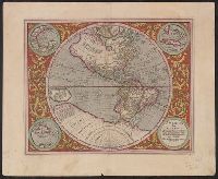
- Ancillary maps: Golfo Mexicano, Cuba, Haiti nunc Hispaniola., Includes notes and decorative floral border., Map was published in "Atlas sive Cosmographicae" by Jodocus Hondius in 1613. Map was again published in the 1623 and 1630 edition by Henricus Hondius., Relief shown pictorially., Sheet measures 47.7 x 58.2 cm. Cross Collection no. 115., and Verso: signature "M" on page 39, page 40. Text in Latin.
- Publisher:
- s.n.,
- Subject (Geographic):
- America--Maps--Early works to 1800 and Western Hemisphere--Maps--Early works to 1800
- Subject (Name):
- Hondius, Hendrik, 1597-1651. Atlas sive Cosmographicae and Hondius, Jodocus, 1563-1612. Atlas sive Cosmographicae
- Found in:
- Beinecke Rare Book and Manuscript Library > America, siue, India Nova : ad magnae Gerardi Mercatoris aui vniversalis imitationem in compendium redacta / per Michaelem Mercatorem, Duysburgensem.
- Creator:
- Blaeu, Willem Janszoon, 1571-1638
- Published / Created:
- after 1645]
- Call Number:
- 70 164X
- Container / Volume:
- BRBL_00353
- Image Count:
- 1
- Resource Type:
- Maps, Atlases & Globes
- Description:
- Library's copy stamped on backing: Yale University Library, Karpinski-Von Wieser Map Collection., Relief shown pictorially., and State 5 (after 1645) with newly engraved sea around embellishments, especially in area found within 10⁰ and 20⁰ S, 240⁰ and 250⁰ lon
- Publisher:
- Blaeu?,
- Subject (Geographic):
- America--Maps--Early works to 1800
- Found in:
- Beinecke Rare Book and Manuscript Library > Americae nova tabula / auct: Guiljelmo Blaeuw.
- Creator:
- Schenk, Peter, 1660-1718 or 1719
- Published / Created:
- 1700?]
- Call Number:
- 331 1700A
- Container / Volume:
- BRBL_00078
- Image Count:
- 1
- Resource Type:
- Maps, Atlases & Globes
- Description:
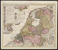
- "Cum privil.", Appears in Schenk's Atlas contractus ... [Amsterdam : Peter Schenk, ca. 1700]., Imperfect: Mutilated, with some loss of text. Sheet measures 53.5 x 62 cm. Verso: "19" (?) in ink ms., Insets: Batavorum colon, and Relief shown pictorially.
- Publisher:
- Peter Schenk?
- Subject (Geographic):
- East Indies--Maps--Early works to 1800, Netherlands--Maps--Early works to 1800, and New Netherland--Maps--Early works to 1800
- Found in:
- Beinecke Rare Book and Manuscript Library > Belgii pars septentrionalis communi nomine vulgo Hollandia : nuncupata continens statum potentissimae Batavorum Reipublicae seu Provincias VII. foederatas. Cum omnium provinciarum insignibus, additis omnibus nominibus urbium et pagorum edente / Petro Sche
7.
- Creator:
- Robijn, Jacobus, d. ca. 1710
- Published / Created:
- 1687
- Call Number:
- 7855 1687
- Container / Volume:
- BRBL_00691
- Image Count:
- 1
- Resource Type:
- Maps, Atlases & Globes
- Description:
- Below title in cartouche: "Met privilegio voor 15 iaaren ao 1687.", Depths shown by soundings., Dutch and French., Inset map: Le partie du Carolina grand point., and Sheet measures 44.3 x 56.7 cm. Cross Collection no. 220.
- Publisher:
- s.n.],
- Subject (Geographic):
- Atlantic Coast (South Atlantic States)--Nautical charts--Early works to 1800 and South Carolina--Nautical charts--Early works to 1800
- Subject (Topic):
- Nautical charts--Atlantic Coast (South Atlantic States)--Early works to 1800 and Nautical charts--South Carolina--Early works to 1800
- Found in:
- Beinecke Rare Book and Manuscript Library > Caerte vande cust Carolina : tusschen B. de S Matheo en C. Henry / op niew verbeetert door Iacobus Robyn.
- Creator:
- Chatelain, Henri Abraham
- Published / Created:
- between 1719 and 1739?]
- Call Number:
- 71 1719D
- Container / Volume:
- BRBL_00361
- Image Count:
- 1
- Resource Type:
- Maps, Atlases & Globes
- Description:
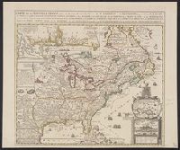
- Insets: Les environs de Quebec -- Veüe de Quebec -- Les costes de la Louisiane., Relief shown pictorially., Same title appears in description of Chatelain's Atlas historique, 1732-39 ed., in Phillips' A list of geographical atlases ..., 579., and Yale's copy st
- Publisher:
- Châtelain?,
- Subject (Geographic):
- New France--Maps--Early works to 1800 and North America--Maps--Early works to 1800
- Found in:
- Beinecke Rare Book and Manuscript Library > Carte de la Nouvelle France : où se voit le cours des Grandes Rivieres de S. Laurens & de Mississipi, aujour d'hui S. Louis, aux environs des-quelles se trouvent les etats, païs, nations, peuples &c. de la Floride, de la Louïsiane, de la Virginie, de l
- Creator:
- Linschoten, Jan Huygen van, 1563-1611
- Published / Created:
- 1596?]
- Call Number:
- 63 1596
- Container / Volume:
- BRBL_00334
- Image Count:
- 1
- Resource Type:
- Maps, Atlases & Globes
- Alternative Title:
- Affbeeldinghe der custen des landts genaempt terra do Natal, item van alle de custen van Coffala, Mozambique, Melinde and Typus orarum maritimarum Guineae, Manicongo, & Angôlae ultra promontorium Bonae Spei.
- Description:
- Appears in the author's Itinerario, voyage ofte schipvaert van Jan Huygen van Linschoten naer Oost ofte Portugaels Indien., Companion map to Typus orarum maritimarum Guineae, Manicongo, & Angôlae ultra promontorium Bonae Spei ..., and Includes decorative carto
- Publisher:
- Cornelis Claesz?,
- Subject (Geographic):
- Africa, Eastern--Maps--Early works to 1800
- Subject (Name):
- Claesz, Cornelis, approximately 1546-1609, Langren, Arnold Florent van, 1580-1644, and Linschoten, Jan Huygen van, 1563-1611. Itinerario, voyage ofte schipvaert van Jan Huygen van Linschoten naer Oost ofte Portugaels Indien
- Subject (Topic):
- Coasts--Africa, Eastern--Maps--Early works to 1800
- Found in:
- Beinecke Rare Book and Manuscript Library > Delineatio orarum maritimarum, terrae vulgo indigetatae terra do Natal item Sofalae, Mozambicae & Melindae ... [cartographic material] = Affbeeldinghe der custen des landts genaempt terra do Natal, item van alle de custen van Coffala, Mozambique, Melinde
- Creator:
- Linschoten, Jan Huygen van, 1563-1611
- Published / Created:
- 1596?]
- Call Number:
- 63 1596
- Container / Volume:
- BRBL_00334
- Image Count:
- 1
- Resource Type:
- Maps, Atlases & Globes
- Alternative Title:
- Affbeeldinghe der custen des landts genaempt terra do Natal, item van alle de custen van Coffala, Mozambique, Melinde and Typus orarum maritimarum Guineae, Manicongo, & Angôlae ultra promontorium Bonae Spei.
- Description:
- Appears in the author's Itinerario, voyage ofte schipvaert van Jan Huyge, Companion map to Typus orarum maritimarum Guineae, Manicongo, & Angôlae ultra promontorium Bonae Spei ..., Has watermark., and Includes decorative cartouche and compass rose and col. ill.
- Publisher:
- Cornelis Claesz?,
- Subject (Geographic):
- Africa, Eastern--Maps--Early works to 1800
- Subject (Name):
- Claesz, Cornelis, approximately 1546-1609, Langren, Arnold Florent van, 1580-1644, and Linschoten, Jan Huygen van, 1563-1611. Itinerario, voyage ofte schipvaert van Jan Huygen van Linschoten naer Oost ofte Portugaels Indien
- Subject (Topic):
- Coasts--Africa, Eastern--Maps--Early works to 1800
- Found in:
- Beinecke Rare Book and Manuscript Library > Delineatio orarum maritimarum, terrae vulgo indigetatae terra do Natal item Sofalae, Mozambicae & Melindae ... [cartographic material] = Affbeeldinghe der custen des landts genaempt terra do Natal, item van alle de custen van Coffala, Mozambique, Melinde