Skip to search
Skip to main content
Skip to first result
Search
You Searched For
Extent of Digitization
Completely digitized
Language
Latin
Publication Place
[London] :
Search Results
Creator:
Published / Created:
[1625]
Call Number:
BrSides Box 2019 15
Image Count:
2
Resource Type:
Maps, Atlases & Globes
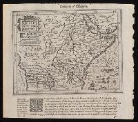
Description:
Relief shown pictorially.
Publisher:
[Printed by William Stansby for Henrie Fetherstone],
Subject (Geographic):
Africa, Central--Maps--Early works to 1800.
Subject (Name):
Featherstone, Henry, -1647, bookseller., Purchas, Samuel, 1577?-1626. Purchas his Pilgrimage. 1625., and Stansby, William, active 1597-1638, printer.
Found in:
Beinecke Rare Book and Manuscript Library > Abissinorum Regnu[m].
Creator:
Published / Created:
1652
Call Number:
70 1652
Container / Volume:
BRBL_00685
Image Count:
1
Resource Type:
Maps, Atlases & Globes
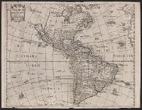
Description:
From Heylin's Cosmographie ... London : Printed for Henry Seile ..., 1652.
Publisher:
Impensis Henrici Seile,
Subject (Geographic):
America--Maps--Early works to 1800
Subject (Name):
Heylyn, Peter, 1600-1662. Microcosmus and Trevethen, William, engraver
Found in:
Beinecke Rare Book and Manuscript Library > Americae descriptio nova / Will. Trevethen, sculp.
Creator:
Published / Created:
[1625]
Call Number:
BrSides Box 2019 13
Image Count:
2
Resource Type:
Maps, Atlases & Globes
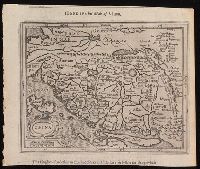
Alternative Title:
Hondius his map of China and Hondivs his map of China
Description:
North oriented towards the right.
Publisher:
[Printed by William Stansby for Henrie Fetherstone],
Subject (Geographic):
China.
Subject (Name):
Featherstone, Henry, -1647, bookseller, Purchas, Samuel, 1577?-1626. Purchas his Pilgrimage. 1625., and Stansby, William, active 1597-1638, printer
Found in:
Beinecke Rare Book and Manuscript Library > China.
Creator:
Published / Created:
1725
Call Number:
48 1725
Container / Volume:
BRBL_00684
Image Count:
1
Resource Type:
Maps, Atlases & Globes
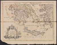
Alternative Title:
Graeciae pars meridionalis and Graeciae pars septentrionalis
Description:
Appears in Senex's Modern geography, or, All the known countries in the world ... [London]: For T. Bowles & T. Bowles & Son, [1708-1725]
Publisher:
Prostant venales apud I. Senex ... ,
Subject (Geographic):
Crete (Greece)--Maps--Early works to 1800, Greece--History--Early works to 1800--Maps, Kyklades (Greece)--Maps--Early works to 1800, and Turkey--History--Early works to 1800--Maps
Subject (Name):
Senex, John, d. 1740. Modern geography, or, All the known countries in the world
Found in:
Beinecke Rare Book and Manuscript Library > Graeciae antiquae tabula nova : in qua locorum situs tum ad distantias itinerarias tum ad observationes astronomicas exactus litorum flexurae et alia id genus ad accuratas recentiorum rationes accomodatae su[n]t / autore Guillelmo Delisle, ex Regia Scient
Creator:
Published / Created:
[between 1715 and 1720?]
Call Number:
400 1715A
Container / Volume:
BRBL_00232
Image Count:
1
Resource Type:
Maps, Atlases & Globes
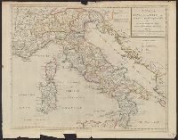
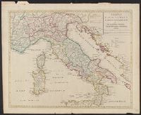
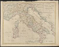
Description:
Relief shown pictorially.
Publisher:
Sold by I. Senex at the globe over against St. Dunstan's Church in Fleetstreet ... ,
Subject (Geographic):
Italy--Historical geography--Maps--Early works to 1800, Italy--History--To 476--Maps--Early works to 1800, and Rome--Maps--Early works to 1800
Subject (Name):
Senex, John, d. 1740
Found in:
Beinecke Rare Book and Manuscript Library > Tabula Italiae antiquae in regiones XI ad Augusto divisiae et tum ad mensuras itineraris tum ad observationes astronomicas exactae / accurante Guillelmo Del'isle ... ; Joan. Bap. Liébaux sculpsit.
Creator:
Published / Created:
[between 1715 and 1720?]
Call Number:
400 1715A
Container / Volume:
BRBL_00232
Image Count:
1
Resource Type:
Maps, Atlases & Globes
Description:
Relief shown pictorially.
Publisher:
Sold by I. Senex at the globe over against St. Dunstan's Church in Fleetstreet ... ,
Subject (Geographic):
Italy--Historical geography--Maps--Early works to 1800, Italy--History--To 476--Maps--Early works to 1800, and Rome--Maps--Early works to 1800
Subject (Name):
Senex, John, d. 1740
Found in:
Beinecke Rare Book and Manuscript Library > Tabula Italiae antiquae in regiones XI ad Augusto divisiae et tum ad mensuras itineraris tum ad observationes astronomicas exactae / accurante Guillelmo Del'isle ... ; Joan. Bap. Liébaux sculpsit.
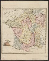
Published / Created:
1790
Call Number:
380 No. 4
Container / Volume:
BRBL_00173
Image Count:
1
Resource Type:
Maps, Atlases & Globes
Publisher:
T. Stackhouse,
Subject (Geographic):
France--Maps--Early works to 1800
Found in:
Beinecke Rare Book and Manuscript Library > [Ancient France] Gallia Antiqua. Engraved by S. J. Neele.
Branch:v1.68.6 ,Deployed:2025-07-02T08:09:49-04:00