Skip to search
Skip to main content
Skip to first result
Search
You Searched For
"Africa--Maps--Early works to 1800"
Language
English
Publication Place
London :
New Search
Search Results
Creator:
Published / Created:
1st January 1789.
Call Number:
655 1789
Container / Volume:
BRBL_00345
Image Count:
1
Resource Type:
Maps, Atlases & Globes
Description:
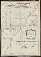
"This map is copied from an original drawn by Monsr. D'Anv, Also appeared in Kitchin's General atlas describing the whole universe. London : Printed for Robert Sayer, [1780]., Prime meridians: Ferro and London., and Relief shown pictorially; depths by soundings.
Publisher:
Printed for Robert Sayer,
Subject (Geographic):
Africa , West--Maps --Early works to 1800
Subject (Name):
Abbot, Charles,--Baron Colchester,--1757-1829--Bookplate, Anville, Jean Baptiste Bourguignon d', 1697-1782, Kitchin, Thomas, d. 1784. General atlas describing the whole universe, and Robert Laurie and James Whittle
Subject (Topic):
Coasts--Africa , West--Maps --Early works
Found in:
Beinecke Rare Book and Manuscript Library > The western coast of Africa, from Cape Blanco to Cape Virga, exhibiting Senegambia proper / by T. Jefferys.
Published / Created:
1792
Call Number:
60cea 1792
Container / Volume:
BRBL_00329
Image Count:
1
Resource Type:
Maps, Atlases & Globes
Description:
Insets: Road of Bissao Ca. 1:60,000, Is, de Loss Ca. 1:100,000, Bananas I., East Point Ca. 1:60,000, Plaintain I., East end Ca. 1:45,000.
Publisher:
Robt. Sayer,
Subject (Geographic):
Africa --Maps --Early works to 1800
Found in:
Beinecke Rare Book and Manuscript Library > A new Survey of the Coast of Africa from Senegal and Cape Verd to Cape St. Ann ...
Published / Created:
1794
Call Number:
60cea 1794
Container / Volume:
BRBL_00329
Image Count:
1
Resource Type:
Maps, Atlases & Globes
Description:
Inset: Bay & Town of Mogadore. Ca. 1:20,000.
Publisher:
Laurie & Whittle,
Subject (Geographic):
Africa --Maps --Early works to 1800
Found in:
Beinecke Rare Book and Manuscript Library > A new chart of the Coast of Africa from the Straits of Gibralter to Cape Blanco with Madeira & the Canary Islands ...
Creator:
Published / Created:
1792
Call Number:
60 1795B
Container / Volume:
BRBL_00324
Image Count:
1
Resource Type:
Maps, Atlases & Globes
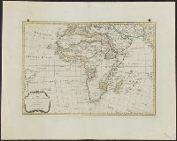
Description:
"Engraved for Guthries New system of geography." and Relief shown pictorially.
Publisher:
C. Dilly & G. Robinson,
Subject (Geographic):
Africa --Maps --Early works to 1800
Subject (Name):
Dilly, Charles, 1739-1807, Guthrie, William, 1708-1770. Atlas to Guthrie's system of geography, and Robinson, G. G. (George G.)
Found in:
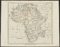
Beinecke Rare Book and Manuscript Library > Africa according to the best authorities.
Creator:
Published / Created:
1794
Call Number:
60 1794C
Container / Volume:
BRBL_00324
Image Count:
1
Resource Type:
Maps, Atlases & Globes
Description:
In top and bottom right margin: 34., Prime meridian: Ferro., and Relief shown pictorially.
Publisher:
Laurie & Whittle, 53 Fleet Street,
Subject (Geographic):
Africa --Maps --Early works to 1800
Subject (Name):
Robert Laurie and James Whittle
Found in:
Beinecke Rare Book and Manuscript Library > Africa and it's several regions / by Samuel Dunn, mathematician.
Creator:
Published / Created:
June 28th, 1780.
Call Number:
39cea 1780
Container / Volume:
BRBL_00192
Image Count:
1
Resource Type:
Maps, Atlases & Globes
Description:
Also appeared in Faden's General atlas. London : William Faden, 1811?., Depths shown by soundings., and Shows ports, sailing directions, etc.
Publisher:
Engraved & published by Wm. Faden,
Subject (Geographic):
Mediterranean Sea--Maps--Early works to 1800
Subject (Name):
Abbot, Charles,--Baron Colchester,--1757-1829--Bookplate and Faden, William, 1749-1836. General atlas
Subject (Topic):
Coasts--Africa , North--Maps --Early
Found in:
Beinecke Rare Book and Manuscript Library > A chart of the coasts of Spain and Portugal, with the Balearic Islands, and part of the coast of Barbary / by L.S. De la Rochette.
Creator:
Published / Created:
August 12th, 1768.
Call Number:
655 1768
Container / Volume:
BRBL_00345
Image Count:
1
Resource Type:
Maps, Atlases & Globes
Description:
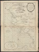
"This map is copied from an original drawn by Monsr. D'Anville ... & published at Paris in 1751. But since the Peace of 1762, that map has been supressed [sic] ... ", Includes descriptive notes,, Prime meridians: Ferro and London., and Relief shown pictorially.
Publisher:
Printed for Robert Sayer in Fleet Street & Thomas Jefferys in the Strand,
Subject (Geographic):
Africa , West--Maps --Early works to 1800
Subject (Name):
Anville, Jean Baptiste Bourguignon d', 1697-1782 and Sayer, Robert, 1725-1794
Found in:
Beinecke Rare Book and Manuscript Library > The western coast of Africa, from Cape Blanco to Cape Virga, exhibiting Senegambia proper / by T. Jefferys.
Branch:v1.61.8 ,Deployed:2024-06-20T11:14:55-04:00