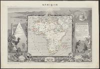
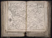
Relief shown by hachures., Coordinates not present on map and are approximated., In upper margins: Atlas universel illustré ... Ancien continent., Includes engraved illustrations in borders, statistics, descriptive text., Inset views: Alexandrie -- Le Caire -- Alger., and Appears in V. Levasseur's Atlas national illustré.
Publisher:
Chez A. Combette, editeur, rue de la Parcheminerie 15 and Impie. de Lemercier
Anville, Jean Baptiste Bourguignon d', 1697-1782 Gravelot, Sr Major, Sr
Published / Created:
1746
Call Number:
2003 Folio 85
Image Count:
1
Description:
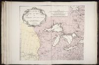
Inset map: [Hudson Bay-Labrador Region]. and No. 2 of 45 maps bound together with binder’s spine title: Atlas of America; ms. table of contents. Bookplate of Paul Mellon.
Anville, Jean Baptiste Bourguignon d', 1697-1782 Haye, G. de la
Published / Created:
avec privilege 1748
Call Number:
2003 Folio 85
Image Count:
1
Description:
Hand colored., 2003 Folio 85: No. 43 of 45 maps bound together with binder’s spine title: Atlas of America, Bookplate: Robinson. Bookplate of Paul Mellon, Relief shown pictorially., and Scale [ca. 1:2,500,000]
BEIN 2003 Folio 85: No. 42 of 45 maps bound together with binder's spine title: Atlas of America; ms. table of contents. Bookplate: Robinson. Bookplate of Paul Mellon., Hand colored., par le Sr. Robert de Vaugondy, fils de Mr. Robert, geographe ordinaire du roy., Relief shown pictorially., and Scale [ca. 1:17,000,000]
Anville, Jean Baptiste Bourguignon d', 1697-1782 Haye, G. de la
Published / Created:
Novembre 1755
Call Number:
2003 Folio 85
Image Count:
1
Description:
BEIN 2003 Folio 85: No. 3 of 45 maps bound together with binder's spine title: Atlas of America; ms. table of contents. Bookplate: Robinson. Bookplate of Paul Mellon., From the author's Atlas general. 1743-80., Hand colored., Has watermarks., National Maritime Museum. Catalog,, par le Sr. d'Anville ... ; [Gravee par] G. De-La-Haye., Relief shown pictorially., Scale [ca. 1:2,750,000]., and Sous le privilege de l'Academie.
Publisher:
Chez l'auteur, aux galeries du Louvre
Subject (Geographic):
Canada -- Maps -- Early works to 1800, Louisiana -- Maps -- Early works to 1800, and North America -- Maps -- Early works to 1800