Skip to search
Skip to main content
Skip to first result
Search
You Searched For
Extent of Digitization
Completely digitized
Creator
Geological Survey (U.S.)
Search Results
Creator:
Published / Created:
1910
Call Number:
BrSides Double Folio 2019 84
Image Count:
1
Resource Type:
Maps, Atlases & Globes
Alternative Title:
Leadville special and Leadville special map
Description:
"Surveyed in 1879. Railroads and some shafts added later."
Publisher:
U.S. Geological Survey,
Subject (Geographic):
Leadville (Colo.)--Maps.
Subject (Name):
Wilson, A. D.
Subject (Topic):
Mines and mineral resources--Colorado--Leadville--Maps.
Found in:
Beinecke Rare Book and Manuscript Library > Colorado (Lake County), Leadville special map [cartographic material] / triangulation and topography by A.D. Wilson, chief topographer.
Creator:
Published / Created:
1906
Call Number:
BrSides Folio 2019 61
Image Count:
1
Resource Type:
Maps, Atlases & Globes
Alternative Title:
Central City special map
Description:
"Surveyed in 1904."
Publisher:
The Survey,
Subject (Geographic):
Central City (Colo.)--Maps. and Colorado--Central City
Subject (Name):
Chapman, Pearson, Douglas, E. M. (Edward Morehouse), 1855-1932, Moor, D. F., and Tweedy, Frank, 1854-1937
Subject (Topic):
Gold mines and mining--Colorado--Central City--Maps. and Mines and mineral resources--Colorado--Central City--Maps.
Found in:
Beinecke Rare Book and Manuscript Library > Colorado, Central City special map [cartographic material] / U.S. Geological Survey ; E.M. Douglas, geographer ; Frank Tweedy, in charge of section ; topography by Pearson Chapman and D.F. Moor ; triangulation by Frank Tweedy.
Creator:
Published / Created:
1916
Call Number:
304ed 1916
Container / Volume:
BRBL_00034A
Image Count:
1
Resource Type:
Maps, Atlases & Globes
Alternative Title:
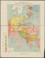
Central and South Eastern Europe.
Description:
"G.S., G.S., no. 2824."
Publisher:
Drawn and printed at the War Office,
Subject (Geographic):
Europe, Central--Maps
Found in:
Beinecke Rare Book and Manuscript Library > Ethnographical Map of Central & South Eastern Europe.
Creator:
Published / Created:
1905?]
Call Number:
837gce T764 1905
Container / Volume:
BRBL_00594
Image Count:
1
Resource Type:
Maps, Atlases & Globes
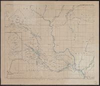
Description:
"Third annual report Reclamation Service, Pl. XXXI."
Publisher:
U.S. G.P.O,
Subject (Name):
A. Hoen & Co and Geological Survey (U.S.). Reclamation Service. Annual report of the Reclamation Service
Subject (Topic):
Irrigation projects--Carson River Watershed (Nev.)--Maps, Irrigation projects--Truckee River Watershed (Calif. and Nev.)--Maps, and Irrigation--Nevada--Maps
Found in:
Beinecke Rare Book and Manuscript Library > General map of Truckee-Carson Project, Nevada / U.S. Geological Survey.
Creator:
Published / Created:
1905?]
Call Number:
847 Y12 1905
Container / Volume:
BRBL_00627
Image Count:
1
Resource Type:
Maps, Atlases & Globes
Description:
In upper margin: U.S. Geological Survey, Third annual report Reclamation Service PL. LVII.
Publisher:
G.P.O.?,
Subject (Geographic):
Yakima River Watershed (Wash.)--Maps
Subject (Name):
Geological Survey (U.S.). Reclamation Service. Annual report of the Reclamation Service and Norris Peters Co
Found in:
Beinecke Rare Book and Manuscript Library > General map of the Yakima Basin, Washington.
Creator:
Published / Created:
1912
Call Number:
848 G95 1912
Container / Volume:
BRBL_00632
Image Count:
1
Resource Type:
Maps, Atlases & Globes
Alternative Title:
Geological Survey bulletin. 498. and Headwater region of Gulkana and Susitna Rivers, Alaska
Description:
"Bulletin 498, Plate I."
Publisher:
Geological Survey,
Subject (Geographic):
Gulkana River Region (Alaska)--Maps and Susitna River Region (Alaska)--Maps
Subject (Name):
Bagley, James Warren, 1881-1947, Brooks, Alfred H. (Alfred Hulse), 1871-1924, Giffin, C. E, and Witherspoon, D. C
Subject (Topic):
Geology--Alaska--Gullkana River Region--Maps and Geology--Alaska--Sustina River Region--Maps
Found in:
Beinecke Rare Book and Manuscript Library > Geologic reconnaissance map of headwater region of Gulkana and Susitna Rivers, Alaska / U.S. Geological Survey. Alfred H. Brooks, geologist in charge of division, topography and triangulation by D.C. Witherspoon, C.E. Giffin and J.W. Bagley.
Creator:
Published / Created:
[1918]
Call Number:
848 J953 1918
Container / Volume:
BRBL_00633
Image Count:
1
Resource Type:
Maps, Atlases & Globes
Description:
"1918."
Publisher:
U.S. Geological Survey,
Subject (Geographic):
Juneau Region (Alaska)--Maps
Subject (Name):
Brooks, Alfred H. (Alfred Hulse), 1871-1924 and Witherspoon, D. C
Found in:
Beinecke Rare Book and Manuscript Library > Juneau and vicinity, Alaska / Alfred H. Brooks, geologist in charge of division ; topography by D.C. Witherspoon.
Creator:
Published / Created:
[1900]
Call Number:
847gc Se18 1897
Container / Volume:
BRBL_00628
Image Count:
1
Resource Type:
Maps, Atlases & Globes
Alternative Title:
Washington, Seattle quadrangle :
Description:
"Henry Gannett, chief topographer; R.U. Goode, geographer in charge; control by W.T. Griswold and R.H. McKee; topography by G.E. Hyde and R.H. McKee; surveyed in 1893-94-95."
Publisher:
U.S.G.S.,
Subject (Geographic):
King County (Wash.)--Maps and Snohomish County (Wash.)--Maps
Subject (Name):
Gannett, Henry, 1846-1914
Subject (Topic):
Forests and forestry--Washington (State)--King County--Maps, Forests and forestry--Washington (State)--Snohomish County--Maps, Land use--Washington (State)--King County--Maps, and Land use--Washington (State)--Snohomish County
Found in:
Beinecke Rare Book and Manuscript Library > Land classification and density of standing timber, Washington, Seattle quadrangle / U.S. Geological Survey.
Creator:
Published / Created:
[1900]
Call Number:
847gc T119 1897
Container / Volume:
BRBL_00628
Image Count:
1
Resource Type:
Maps, Atlases & Globes
Alternative Title:
Washington, Tacoma quadrangle :
Description:
"Henry Gannett, chief topographer; R.U. Goode, geographer in charge; control by W.T. Griswold and U.S. Coast and Geodetic Survey; topography by G.E. Hyde and R.H. McKee; surveyed in 1894-95."
Publisher:
U.S.G.S.,
Subject (Geographic):
King County (Wash.)--Maps and Pierce County (Wash.)--Maps
Subject (Name):
Gannett, Henry, 1846-1914
Subject (Topic):
Forests and forestry--Washington (State)--King County--Maps, Forests and forestry--Washington (State)--Pierce County--Maps, Land use--Washington (State)--King County--Maps, and Land use--Washington (State)--Pierce County--Maps
Found in:
Beinecke Rare Book and Manuscript Library > Land classification and density of standing timber, Washington, Tacoma quadrangle / U.S. Geological Survey.
Creator:
Published / Created:
1913
Call Number:
BrSides Double Folio 2019 127
Image Count:
1
Resource Type:
Maps, Atlases & Globes
Alternative Title:
Colorado (Lake County), Leadville mining district
Description:
"Surveyed in 1911."
Publisher:
The Survey,
Subject (Geographic):
Leadville (Colo.)--Maps
Subject (Name):
Davis, E. P., Marshall, R. B. (Robert Bradford), 1867-1949., Robertson, R. B., Semper, C. H., Tatum, Sledge., and Taylor, S. E.
Subject (Topic):
Mines and mineral resources--Colorado--Leadville--Maps.
Found in:
Beinecke Rare Book and Manuscript Library > Leadville mining district [cartographic material] / U.S. Geological Survey ; R.B. Marshall, chief geographer ; Sledge Tatum, geographer in charge ; topography by E.P. Davis and S.E. Taylor ; control by R.B. Robertson, C.H. Semper, and S.E. Taylor.
Branch:v1.68.6 ,Deployed:2025-07-02T08:09:49-04:00