Skip to search
Skip to main content
Skip to first result
Search
You Searched For
Extent of Digitization
Completely digitized
Creator
Great Britain. Inter-service Topographical Dept
Search Results
Creator:
Published / Created:
1943
Call Number:
38 B75 1943
Container / Volume:
BRBL_00156
Image Count:
1
Resource Type:
Maps, Atlases & Globes
Alternative Title:
France 1:6,670, Great Britain. War Office. General Staff. Geographical Section. [G.S.G.S.] ; 4234, and GSGS (Series) ; 4234.
Description:
"9-43."
Publisher:
Army Map Service, U.S. Army,
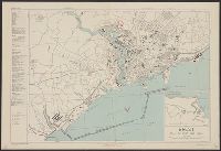
Subject (Geographic):
Brest (France)--Maps
Found in:
Beinecke Rare Book and Manuscript Library > Brest [cartographic material] : plan of port and town / compiled and drawn by Inter-service Topographical Dept.
Creator:
Published / Created:
1944
Call Number:
38 C74 1944
Container / Volume:
BRBL_00157
Image Count:
1
Resource Type:
Maps, Atlases & Globes
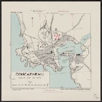
Alternative Title:
Great Britain. War Office. General Staff. Geographical Section. [G.S.G.S.] ; 4234, Great Britain. War Office. General Staff. Geographical Section. G.S.G.S. ; 4234., and GSGS (Series) ; 4234.
Description:
In upper margin: France 1:7,000.
Publisher:
Army Map Service, U.S. Army,
Subject (Geographic):
Concarneau (France)--Maps
Found in:
Beinecke Rare Book and Manuscript Library > Concarneau [cartographic material] : plan of port and town / compiles & drawn by Inter-service Topographical Dept.
Creator:
Published / Created:
1943
Call Number:
38 D34 1944
Container / Volume:
BRBL_00157
Image Count:
1
Resource Type:
Maps, Atlases & Globes
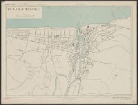
Alternative Title:
France 1:5,800, Geographical Section, General Staff ; no. 4234, and GSGS (Series) ; 4234.
Description:
"1-44, 1944."
Publisher:
Army Map Service, U.S. Army, and War Office ;
Subject (Geographic):
Deauville (France)--Maps and Trouville-sur-Mer (France)--Maps
Found in:
Beinecke Rare Book and Manuscript Library > Deauville-Trouville [cartographic material] / compiled and drawn by Inter-Service Topographical Dept. ; produced under the Superintendence of Vice-Admiral John Edgell, hydrographer.
Creator:
Published / Created:
1943, 1944 printing.
Call Number:
38 D742 1944
Container / Volume:
BRBL_00157
Image Count:
1
Resource Type:
Maps, Atlases & Globes
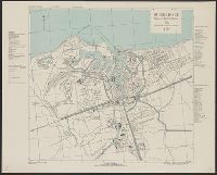
Alternative Title:
France 1:4,000, Geographical Section, General Staff ; no. 4234, and GSGS (Series) ; 4234.
Description:
"1-44."
Publisher:
Army Map Service, U.S. Army, and War Office ;
Subject (Geographic):
Douarnenez (France)--Maps and Tréboul (France)--Maps
Found in:
Beinecke Rare Book and Manuscript Library > Douarnenez-Tréboul [cartographic material] : plan of port and town / compiled and drawn by Inter-Service Topographical Dept. ; produced under the Superintendence of Vice-Admiral John Edgell, hydrographer.
Creator:
Published / Created:
1943
Call Number:
38 D92 1943
Container / Volume:
BRBL_00157
Image Count:
1
Resource Type:
Maps, Atlases & Globes
Alternative Title:
France 1:10,000, Geographical Section, General Staff ; no. 4234, and GSGS (Series) ; 4234.
Description:
"8-43."
Publisher:
Army Map Service, U.S. Army, and War Office ;
Subject (Geographic):
Dunkerque (France)--Maps
Found in:
Beinecke Rare Book and Manuscript Library > Dunkerque [cartographic material] : plan of port & town / compiled and drawn by Inter-Service Topographical Dept. ; produced under the Superintendence of Vice-Admiral John Edgell, hydrographer.
Creator:
Published / Created:
1943, 1944 printing.
Call Number:
38 F31 1944
Container / Volume:
BRBL_00157
Image Count:
1
Resource Type:
Maps, Atlases & Globes
Alternative Title:
France 1:5,000, Geographical Section, General Staff ; no. 4234, and GSGS (Series) ; 4234.
Description:
"1-44."
Publisher:
Army Map Service, U.S. Army, and War Office ;
Subject (Geographic):
Fécamp (France)--Maps
Found in:
Beinecke Rare Book and Manuscript Library > Fécamp, plan of port and town [cartographic material] / compiled and drawn by Inter-Service Topographical Dept. ; produced under the Superintendence of Vice-Admiral John Edgell, hydrographer.
Creator:
Published / Created:
1943
Call Number:
38gma 1943A
Container / Volume:
BRBL_00170
Image Count:
1
Resource Type:
Maps, Atlases & Globes
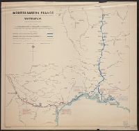
Alternative Title:
G.S.G.S. misc. ; 61. and Geographical Section General Staff misc ; 61
Description:
Shows: canals and rivers with widths and depths.
Publisher:
G.S.G.S.,
Subject (Geographic):
France--Maps
Subject (Name):
Great Britain. War Office. General Staff. Geographical Section
Found in:
Beinecke Rare Book and Manuscript Library > Mediterranean France [cartographic material] : waterways / compiled and drawn by I.S.T.D.
Creator:
Published / Created:
1943, 1944 printing.
Call Number:
38 R81 1944
Container / Volume:
BRBL_00165
Image Count:
1
Resource Type:
Maps, Atlases & Globes
Alternative Title:
France 1:7,350, Geographical Section, General Staff ; no. 4234, GSGS (Series) ; 4234., and Royan, plan of town
Description:
"First A.M.S. ed., 1943."
Publisher:
Army Map Service, U.S. Army, and War Office ;
Subject (Geographic):
Royan (France)--Maps
Found in:
Beinecke Rare Book and Manuscript Library > Royan [cartographic material] : plan of town / compiled and drawn by Inter Service Topographical Dept. ; produced under the Superintendence of Vice-Admiral John Edgell, hydrographer.
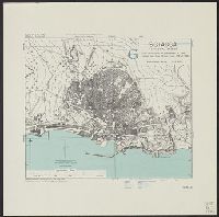
Creator:
Published / Created:
1943
Call Number:
408 Sc12 1943
Container / Volume:
BRBL_00239
Image Count:
1
Resource Type:
Maps, Atlases & Globes
Alternative Title:
Geographical Section, General Staff ; 4379, GSGS (Series) ; 4379., and Sciacca
Description:
"6-43."
Publisher:
Army Map Service, U.S. Army,
Subject (Geographic):
Sciacca (Italy)--Maps
Subject (Name):
Great Britain. War Office. General Staff. Geographical Section and United States. Army Map Service
Found in:
Beinecke Rare Book and Manuscript Library > Sicily 1:5,200. Sciacca / compiled and drawn by Inter-Service Topographical Dept [cartographic material].
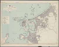
Creator:
Published / Created:
1943, 1944 printing.
Call Number:
38 Sa233 1944
Container / Volume:
BRBL_00165
Image Count:
1
Resource Type:
Maps, Atlases & Globes
Alternative Title:
France 1:6,000, Geographical Section, General Staff ; no. 4234, GSGS (Series) ; 4234., Saint Malo, and St. Malo, plan of port and town
Description:
"G.S.G.S. edition, 1943."
Publisher:
Army Map Service, U.S. Army, and War Office ;
Subject (Geographic):
Saint-Malo (France)--Maps
Found in:
Beinecke Rare Book and Manuscript Library > St. Malo [cartographic material] : plan of port and town / compiled and drawn by Inter-Service Topographical Dept. ; produced under the Superintendence of Vice-Admiral John Edgell, hydrographer.
Branch:v1.68.7 ,Deployed:2025-07-09T09:07:56-04:00