Skip to search
Skip to main content
Skip to first result
Search
You Searched For
Extent of Digitization
Completely digitized
Repository
Beinecke Rare Book and Manuscript Library
Creator
Great Britain. Inter-service Topographical Dept
Search Results
Creator:
Published / Created:
1943
Call Number:
38 B75 1943
Container / Volume:
BRBL_00156
Image Count:
1
Resource Type:
Maps, Atlases & Globes
Alternative Title:
France 1:6,670, Great Britain. War Office. General Staff. Geographical Section. [G.S.G.S.] ; 4234, and GSGS (Series) ; 4234.
Description:
"9-43."
Publisher:
Army Map Service, U.S. Army,
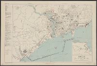
Subject (Geographic):
Brest (France)--Maps
Found in:
Beinecke Rare Book and Manuscript Library > Brest [cartographic material] : plan of port and town / compiled and drawn by Inter-service Topographical Dept.
Creator:
Published / Created:
1944
Call Number:
38 C74 1944
Container / Volume:
BRBL_00157
Image Count:
1
Resource Type:
Maps, Atlases & Globes
Alternative Title:
Great Britain. War Office. General Staff. Geographical Section. [G.S.G.S.] ; 4234, Great Britain. War Office. General Staff. Geographical Section. G.S.G.S. ; 4234., and GSGS (Series) ; 4234.
Description:
In upper margin: France 1:7,000.
Publisher:
Army Map Service, U.S. Army,
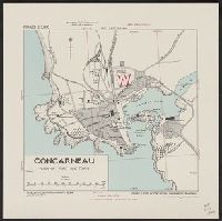
Subject (Geographic):
Concarneau (France)--Maps
Found in:
Beinecke Rare Book and Manuscript Library > Concarneau [cartographic material] : plan of port and town / compiles & drawn by Inter-service Topographical Dept.
Creator:
Published / Created:
1943
Call Number:
38 D34 1944
Container / Volume:
BRBL_00157
Image Count:
1
Resource Type:
Maps, Atlases & Globes
Alternative Title:
France 1:5,800, Geographical Section, General Staff ; no. 4234, and GSGS (Series) ; 4234.
Description:
"1-44, 1944."
Publisher:
Army Map Service, U.S. Army, and War Office ;
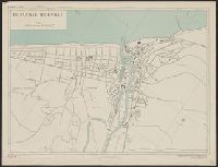
Subject (Geographic):
Deauville (France)--Maps and Trouville-sur-Mer (France)--Maps
Found in:
Beinecke Rare Book and Manuscript Library > Deauville-Trouville [cartographic material] / compiled and drawn by Inter-Service Topographical Dept. ; produced under the Superintendence of Vice-Admiral John Edgell, hydrographer.
Creator:
Published / Created:
1943, 1944 printing.
Call Number:
38 D742 1944
Container / Volume:
BRBL_00157
Image Count:
1
Resource Type:
Maps, Atlases & Globes
Alternative Title:
France 1:4,000, Geographical Section, General Staff ; no. 4234, and GSGS (Series) ; 4234.
Description:
"1-44."
Publisher:
Army Map Service, U.S. Army, and War Office ;
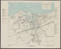
Subject (Geographic):
Douarnenez (France)--Maps and Tréboul (France)--Maps
Found in:
Beinecke Rare Book and Manuscript Library > Douarnenez-Tréboul [cartographic material] : plan of port and town / compiled and drawn by Inter-Service Topographical Dept. ; produced under the Superintendence of Vice-Admiral John Edgell, hydrographer.
Creator:
Published / Created:
1943
Call Number:
38 D92 1943
Container / Volume:
BRBL_00157
Image Count:
1
Resource Type:
Maps, Atlases & Globes
Alternative Title:
France 1:10,000, Geographical Section, General Staff ; no. 4234, and GSGS (Series) ; 4234.
Description:
"8-43."
Publisher:
Army Map Service, U.S. Army, and War Office ;
Subject (Geographic):
Dunkerque (France)--Maps
Found in:
Beinecke Rare Book and Manuscript Library > Dunkerque [cartographic material] : plan of port & town / compiled and drawn by Inter-Service Topographical Dept. ; produced under the Superintendence of Vice-Admiral John Edgell, hydrographer.
Creator:
Published / Created:
1943, 1944 printing.
Call Number:
38 F31 1944
Container / Volume:
BRBL_00157
Image Count:
1
Resource Type:
Maps, Atlases & Globes
Alternative Title:
France 1:5,000, Geographical Section, General Staff ; no. 4234, and GSGS (Series) ; 4234.
Description:
"1-44."
Publisher:
Army Map Service, U.S. Army, and War Office ;
Subject (Geographic):
Fécamp (France)--Maps
Found in:
Beinecke Rare Book and Manuscript Library > Fécamp, plan of port and town [cartographic material] / compiled and drawn by Inter-Service Topographical Dept. ; produced under the Superintendence of Vice-Admiral John Edgell, hydrographer.
Creator:
Published / Created:
1943
Call Number:
38gma 1943A
Container / Volume:
BRBL_00170
Image Count:
1
Resource Type:
Maps, Atlases & Globes
Alternative Title:
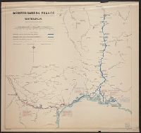
G.S.G.S. misc. ; 61. and Geographical Section General Staff misc ; 61
Description:
Shows: canals and rivers with widths and depths.
Publisher:
G.S.G.S.,
Subject (Geographic):
France--Maps
Subject (Name):
Great Britain. War Office. General Staff. Geographical Section
Found in:
Beinecke Rare Book and Manuscript Library > Mediterranean France [cartographic material] : waterways / compiled and drawn by I.S.T.D.
Creator:
Published / Created:
1943, 1944 printing.
Call Number:
38 R81 1944
Container / Volume:
BRBL_00165
Image Count:
1
Resource Type:
Maps, Atlases & Globes
Alternative Title:
France 1:7,350, Geographical Section, General Staff ; no. 4234, GSGS (Series) ; 4234., and Royan, plan of town
Description:
"First A.M.S. ed., 1943."
Publisher:
Army Map Service, U.S. Army, and War Office ;
Subject (Geographic):
Royan (France)--Maps
Found in:
Beinecke Rare Book and Manuscript Library > Royan [cartographic material] : plan of town / compiled and drawn by Inter Service Topographical Dept. ; produced under the Superintendence of Vice-Admiral John Edgell, hydrographer.
Creator:
Published / Created:
1943
Call Number:
408 Sc12 1943
Container / Volume:
BRBL_00239
Image Count:
1
Resource Type:
Maps, Atlases & Globes
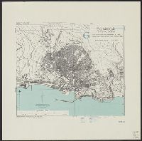
Alternative Title:
Geographical Section, General Staff ; 4379, GSGS (Series) ; 4379., and Sciacca
Description:
"6-43."
Publisher:
Army Map Service, U.S. Army,
Subject (Geographic):
Sciacca (Italy)--Maps
Subject (Name):
Great Britain. War Office. General Staff. Geographical Section and United States. Army Map Service
Found in:
Beinecke Rare Book and Manuscript Library > Sicily 1:5,200. Sciacca / compiled and drawn by Inter-Service Topographical Dept [cartographic material].
Creator:
Published / Created:
1943, 1944 printing.
Call Number:
38 Sa233 1944
Container / Volume:
BRBL_00165
Image Count:
1
Resource Type:
Maps, Atlases & Globes
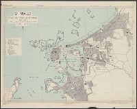
Alternative Title:
France 1:6,000, Geographical Section, General Staff ; no. 4234, GSGS (Series) ; 4234., Saint Malo, and St. Malo, plan of port and town
Description:
"G.S.G.S. edition, 1943."
Publisher:
Army Map Service, U.S. Army, and War Office ;
Subject (Geographic):
Saint-Malo (France)--Maps
Found in:
Beinecke Rare Book and Manuscript Library > St. Malo [cartographic material] : plan of port and town / compiled and drawn by Inter-Service Topographical Dept. ; produced under the Superintendence of Vice-Admiral John Edgell, hydrographer.
Branch:v1.68.7 ,Deployed:2025-07-09T09:08:12-04:00